The best running trails in Ed Jenkins National Recreation Area
56
runners
14
runs
Jogging in Ed Jenkins National Recreation Area offers diverse landscapes within Georgia's Chattahoochee National Forest. The region is characterized by forested mountains, clear streams, and varied ecosystems, including hardwood forests and riparian zones. An extensive trail network provides opportunities for running through the Blue Ridge Mountains, with routes ranging from moderate to difficult. This area covers approximately 23,330 acres, providing a natural setting for outdoor activities.
Best jogging routes in Ed Jenkins National Recreation Area
- The most popular jogging route is Len Foote and Appalachian Approach Loop Trail, a 12.2 miles (19.6 km) trail that takes 2 hours 33 minutes to complete. This difficult route combines sections of two prominent trails, offering a challenging loop.
- Another top favourite among local runners is Appalachian Approach Trail to Springer Mountain, a difficult 14.6 miles (23.5 km) path. This route leads to the southern terminus of the Appalachian Trail, featuring significant elevation gain through forested terrain.
- Local runners also love the Appalachian Trail to Springer Mountain, a 2.0 miles (3.2 km) trail leading through mountain forests, often completed in about 23 minutes.
- Jogging in Ed Jenkins National Recreation Area is defined by forested mountains, clear streams, and an extensive trail network. The routes offer options for various ability levels, from moderate paths to more challenging ascents.
- The guide includes highly-rated routes that showcase the best of the region's landscape. Nearly 60 runners have used komoot to explore Ed Jenkins National Recreation Area's varied terrain.
Last updated: November 7, 2026
15
runners
19.6km
02:33
730m
740m
If you are looking for a challenging jogging route, the Len Foote and Appalachian Approach Loop Trail delivers a demanding 12.2 miles (19.6 km) with a significant 2405 feet (733 metres) of elevation gain. You can expect lung-busting climbs and descents through dense forests, passing the impressive Amicalola Falls and offering glimpses of the southern Appalachian mountains. This difficult route, estimated to take around 2 hours and 33 minutes, features sandy, moss-covered forest floors, creek crossings, and an impressive old-growth tulip tree.
To plan your visit, know that the trail starts in Amicalola Falls State Park before entering the Chattahoochee National Forest. Be prepared for varied and strenuous conditions throughout the route. The Len Foote Hike Inn, a rustic lodge accessible only by foot, is located roughly halfway and provides a good spot to refill water and use facilities.
This loop combines sections of the Len Foote Hike Inn Trail and the iconic Appalachian Approach Trail, making it a notable journey. The Hike Inn itself offers welcome Blue Ridge vistas, adding to the unique experience of this trail. It is a demanding route that truly tests your endurance in a beautiful natural setting.
6
runners
23.5km
03:19
890m
890m
Prepare for a challenging jogging experience on the Appalachian Approach Trail to Springer Mountain. This difficult route spans 14.6 miles (23.5 km) and climbs a significant 2919 feet (890 metres), taking around 3 hours and 19 minutes to complete. As you jog, you will wind through a varied forest of deciduous trees, hemlocks, rhododendrons, and laurels, with rugged terrain underfoot. You will also get close-up views of Amicalola Falls, Georgia's tallest waterfall, before reaching panoramic mountaintop vistas.
When planning your visit, remember that parking is available at the visitor center, which serves as the starting point for this route. It is crucial to carry enough water for your entire journey, as water sources become scarce once you leave Amicalola Falls State Park. Consider starting early to make the most of your time on the trail.
This trail is famously known as the traditional gateway for Appalachian Trail thru-hikers, leading you directly to Springer Mountain, the southern terminus of the Appalachian Trail. At the summit, you will find commemorative plaques marking this significant milestone. The scenery is particularly vibrant with wildflowers in summer and offers colorful foliage during autumn, adding to the unique character of this historic approach.

4
runners
19.2km
02:21
670m
670m
Embark on the Len Foote Hike Inn Loop, a difficult jogging route that challenges you with 2199 feet (670 metres) of elevation gain over 11.9 miles (19.2 km). This trail winds through the beautiful Chattahoochee National Forest, offering varied terrain from soft forest floor to rocky sections, all while providing continuous inclines and declines. You can expect to complete this demanding loop in about 2 hours and 20 minutes, experiencing the rolling Southern Appalachian mountains and spotting abundant wildflowers like pink lady slippers if you visit in spring.
Planning your visit is straightforward, as the trail is well-marked and maintained, making navigation easy. While there are no specific permits mentioned for this route, remember that the Len Foote Hike Inn serves as an excellent spot for a mid-jog rest and to refill your water. This eco-friendly backcountry lodge is a welcome sight along the way, providing a convenient break point during your challenging run.
The Len Foote Hike Inn Loop is a notable trail within Amicalola Falls State Park, known for its substantial workout potential and scenic beauty. It offers a rewarding experience for those seeking a significant physical challenge amidst a natural setting. The presence of the Len Foote Hike Inn itself adds a unique feature, making it more than just a trail but also a destination for a brief respite in the wilderness.
4
runners
3.19km
00:23
120m
120m
Embark on a moderate jogging route along the Appalachian Trail to Springer Mountain, a quick yet rewarding experience. This 2.0 miles (3.2 km) segment guides you through a diverse deciduous forest, where you will often spot mossy boulders along the path. You will gain 378 feet (115 metres) in elevation, and the entire journey typically takes about 23 minutes to complete. Reaching the summit of Springer Mountain offers outstanding westward views of the southern Appalachians, particularly vibrant during wildflower season or autumn.
When planning your visit, you will find that this specific section of the Appalachian Trail is quite manageable for a quick jog. Be aware that while it is shorter, the terrain can still be rocky in certain areas, so wear appropriate footwear. Parking is generally available near the trailhead, making access straightforward for a convenient outing. Consider starting your jog in the morning to enjoy cooler temperatures and clearer views from the summit.
This route provides a taste of the Georgia wilderness without committing to the more strenuous full Approach Trail from Amicalola Falls. It is an excellent way to experience a piece of the iconic Appalachian Trail, known for its extensive network and natural beauty. The trail's setting within the Chattahoochee-Oconee National Forest ensures a peaceful and scenic environment for your activity.
1
runners
6.63km
00:53
210m
210m
Embark on a moderate jogging route that combines the Benton MacKaye, Owen's Overlook, and Appalachian Trails, offering a rewarding workout through diverse landscapes. This 4.1-mile (6.6 km) loop features significant elevation changes, gaining 700 feet (213 metres) over an estimated 53 minutes. As you jog, you will experience rugged terrain, including rocky sections and beautiful views of the southern Appalachian mountains, especially from the Owen Vista.
This route is located within the Blue Ridge Wildlife Management Area, so it is wise to check with local authorities for any required permits before your visit. Parking is generally available near the trailheads that provide access to Springer Mountain, which serves as a common starting point for both major trails. Plan your visit during favorable weather to best enjoy the scenic forests and valleys.
The trail holds historical significance, connecting to the starting points of both the Appalachian Trail and the Benton MacKaye Trail. You will jog through diverse hardwood forests and mossy stream valleys, typical of the Blue Ridge Mountains. This area offers a unique opportunity to experience a section of two iconic long-distance trails, providing a glimpse into their rich heritage and natural beauty.
7.00km
00:53
250m
250m
7.50km
00:53
180m
180m
16.4km
02:02
440m
450m
18.6km
02:30
510m
510m
9
runners
Hard run. Very good fitness required. Mostly paved surfaces.
Get access to more routes and recommendations from other explorers.
Already have an account?
Our route recommendations are based on thousands of hikes, rides, and runs completed by other people on komoot.
Start today with a free account
Your next adventure awaits.
Popular around Ed Jenkins National Recreation Area

Benton MacKaye Trail — Hiking from Georgia to the Smokies
Duncan Ridge Trail — Conquering Georgia’s toughest terrain

Hiking in Ed Jenkins National Recreation Area

MTB Trails in Ed Jenkins National Recreation Area

Gravel biking in Ed Jenkins National Recreation Area

Cycling in Ed Jenkins National Recreation Area
Other adventures in Ed Jenkins National Recreation Area


Tips from the Community

Beautiful overnight accommodation in the heart of nature. There are 20 bedrooms with bunk beds and a mattress for children. Dinner and breakfast are eaten together. On a guided tour of the house, you'll learn about the building's history, the Japanese-inspired architecture, the environmental awards (e.g., about the composting system with worms), the connection to Len Foote, and the observation deck with astronomical art. After dinner, you can enjoy the game room or attend a lecture. The warm showers are very pleasant after the strenuous climb. It's a shame there are no facilities for day visitors. Lunch packs are available for overnight guests. https://hike-inn.com/ The moderate, five-mile trail starting from the top of Amicalola Falls is among the most popular mountain trails in the North Georgia Blue Ridge. And one of its most beautiful and diverse. The two-to-four hour hike crosses small streams, traverses scenic ridges and ambles through stands of mountain laurel and rhododendron. Backpacker magazine included our trail as one of 36 “Best American Hikes” and our Inn is included on National Geographic Traveler’s “Stay List.”
2
0

This mountain reaches an elevation of approximately 3,278 feet, making it an excellent vantage point to see the surrounding area. From here you can look down to the Toccoa River valley.
1
0
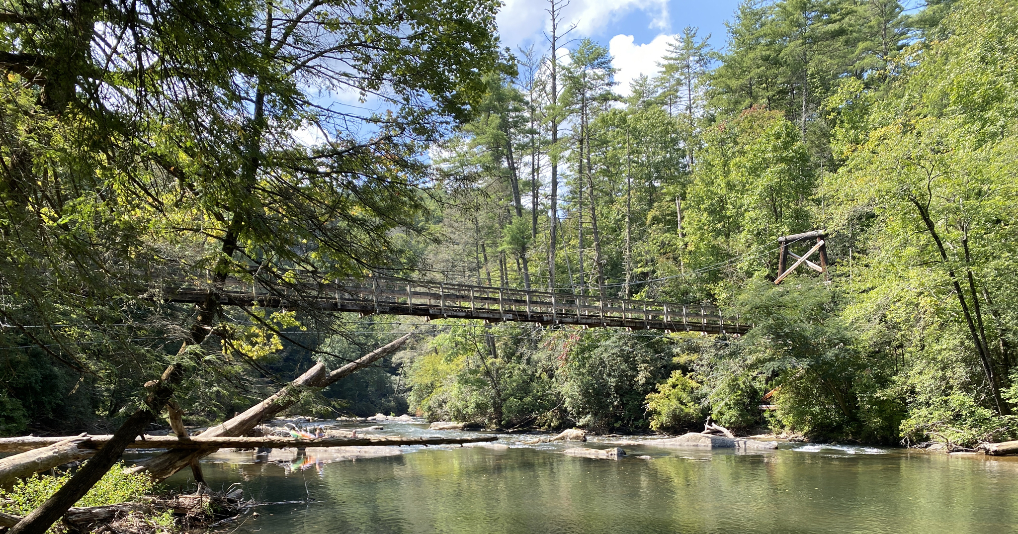
Built in 1977 by the USDA Forest Service in collaboration with the Appalachian Trail Club, it's recognized as the longest swinging bridge east of the Mississippi River, stretching an impressive 270 feet.
1
0

Only accessible by hike! Information at https://hike-inn.com/
5
0
The waterfalls are really something special. The flowing water over the various rock cascades is particularly impressive from below. But the view from above (Top of the Falls) is also recommended. If you want to give your legs a bit of a workout, you can climb a total of 600 steps (first 175 and then another 425) from the foot of the falls to the top.
3
0
The A.T. Approach Trail does not lead directly over the mountain, but along its western slope. There is a water source at the point marked here.
2
0
Springer Mountain is essentially a small rocky plateau with a few views, known for being the southern end of the Appalachian Trail. The trail from Amicalola Falls State Park is beautiful. Camping is not permitted on the summit plateau, but the Springer Mountain Shelter is just 600 feet to the north.
5
0

There are a bunch of short bridges that cross some streams in this area. This section of the Appalachian Trail is really well kept with some trailside campsites and a nearby shelter. Be ready to see other trail users while out running on this trail.
0
0
Frequently Asked Questions
How many running routes are available in the Ed Jenkins National Recreation Area?
There are over a dozen dedicated jogging routes in the Ed Jenkins National Recreation Area, offering a wide range of experiences. These routes vary in length and difficulty, catering to different fitness levels.
What kind of terrain can I expect on the jogging trails in this area?
The Ed Jenkins National Recreation Area offers a diverse range of terrain for runners. You'll find paths varying from relatively smooth surfaces to more challenging singletrack-like conditions with uneven ground, rocks, and roots. Many trails traverse thick forests, while others feature significant elevation gains and dramatic mountain views. Portions of the Appalachian Trail here are noted for being well-maintained.
Are there any running routes that feature waterfalls?
Yes, you can enjoy the beauty of waterfalls while running in the area. Appalachian Trail and Long Creek Falls Loop is a moderate 7.5 km route that leads to the scenic Long Creek Falls, providing a peaceful spot to cool off. Another option is the Long Creek Falls loop via Benton MacKaye Ridge Trail & Noontoola Road, a more challenging 16.4 km run.
Are there any circular running routes in the Ed Jenkins National Recreation Area?
Absolutely! Many runners enjoy the circular routes available. For a challenging loop, consider the Len Foote and Appalachian Approach Loop Trail, which is 19.6 km. A moderate option is the Benton MacKaye, Owen's Overlook, and Appalachian Trail Loop, covering 6.6 km and offering scenic views. Another popular choice is the Appalachian and Benton MacKaye Trail Loop, a 7 km moderate route.
What are some scenic points or landmarks I can see while running?
The area is rich with natural landmarks. Many routes lead to Springer Mountain, the southern terminus of the Appalachian Trail, offering significant views. You can also find dramatic mountain vistas along sections of the Appalachian and Benton MacKaye Trails. The Benton MacKaye, Owen's Overlook, and Appalachian Trail Loop specifically includes Owen's Overlook, known for its scenic beauty.
Are the running trails in Ed Jenkins National Recreation Area suitable for families?
While many trails can be challenging, there are options that families can enjoy. For instance, the 3.2 km Appalachian Trail to Springer Mountain is a moderate route that offers a taste of the iconic trail without being overly strenuous, making it a good choice for active families.
Can I bring my dog on the running trails?
Generally, dogs are welcome on trails within the Chattahoochee National Forest, which includes the Ed Jenkins National Recreation Area. However, they must be kept on a leash at all times to protect wildlife and ensure the safety of other visitors. Always check specific trail regulations before heading out.
What is the best time of year to go running in this region?
Spring and fall are generally considered the best times for running in the Ed Jenkins National Recreation Area. In spring, you can enjoy vibrant wildflower displays, while fall offers stunning foliage. Summers can be warm and humid, but the forested trails provide good shade. Winters are milder but can have occasional cold snaps.
What wildlife might I encounter while running?
The diverse ecosystems of the Ed Jenkins National Recreation Area are home to various wildlife. You might spot deer, and there's a possibility of encountering black bears, especially in more remote areas. Birdwatching is also popular, and the region's riparian zones support a variety of species. Always maintain a respectful distance from wildlife.
Are there any long-distance running options for experienced runners?
Yes, experienced runners will find several challenging long-distance routes. The Appalachian Approach Trail to Springer Mountain is a difficult 23.5 km path with significant elevation gain. Another demanding option is the Len Foote Hike Inn Loop, a 19.2 km difficult route. These trails offer extensive mileage through forested terrain.
What do other runners enjoy most about the Ed Jenkins National Recreation Area?
Runners frequently praise the area's serene natural beauty, the extensive and varied trail network, and the opportunity to experience iconic trails like the Appalachian and Benton MacKaye. The chance to reach significant landmarks like Springer Mountain and enjoy scenic spots like Long Creek Falls are also commonly highlighted as favorite aspects.
Most popular routes in Ed Jenkins National Recreation Area
Most popular attractions in Ed Jenkins National Recreation Area

Get inspired with the komoot mobile app


Explore more
Browse the best Running Trails & Routes in other regions.
