Routes

Planner

Features

Updates

App

Login or Signup

Get the App

Login or Signup

Routes
Places to see
North America
Canada
British Columbia

Cariboo Mountains

Attractions and Places To See in the Cariboo Mountains - Top 20

Attractions and places to see in the Cariboo Mountains feature a diverse landscape of rugged peaks, ancient forests, and pristine lakes within British Columbia, Canada. This region is characterized by significant natural features, including expansive provincial parks and numerous waterfalls. It also holds cultural importance with sites reflecting the 1860s Cariboo Gold Rush era and Indigenous heritage. The area offers a range of outdoor exploration opportunities.

Best attractions and places to see in the Cariboo Mountains

  • The most popular attractions is Spahats Creek Falls, a waterfall that plunges 61 meters into a massive canyon. The canyon was formed by glacial meltwater about 11,000 years ago.
  • Another must-see spot is Moul Falls, a waterfall. This waterfall plunges 35 meters over an eroded rock ledge, and it is possible to walk behind the falls.
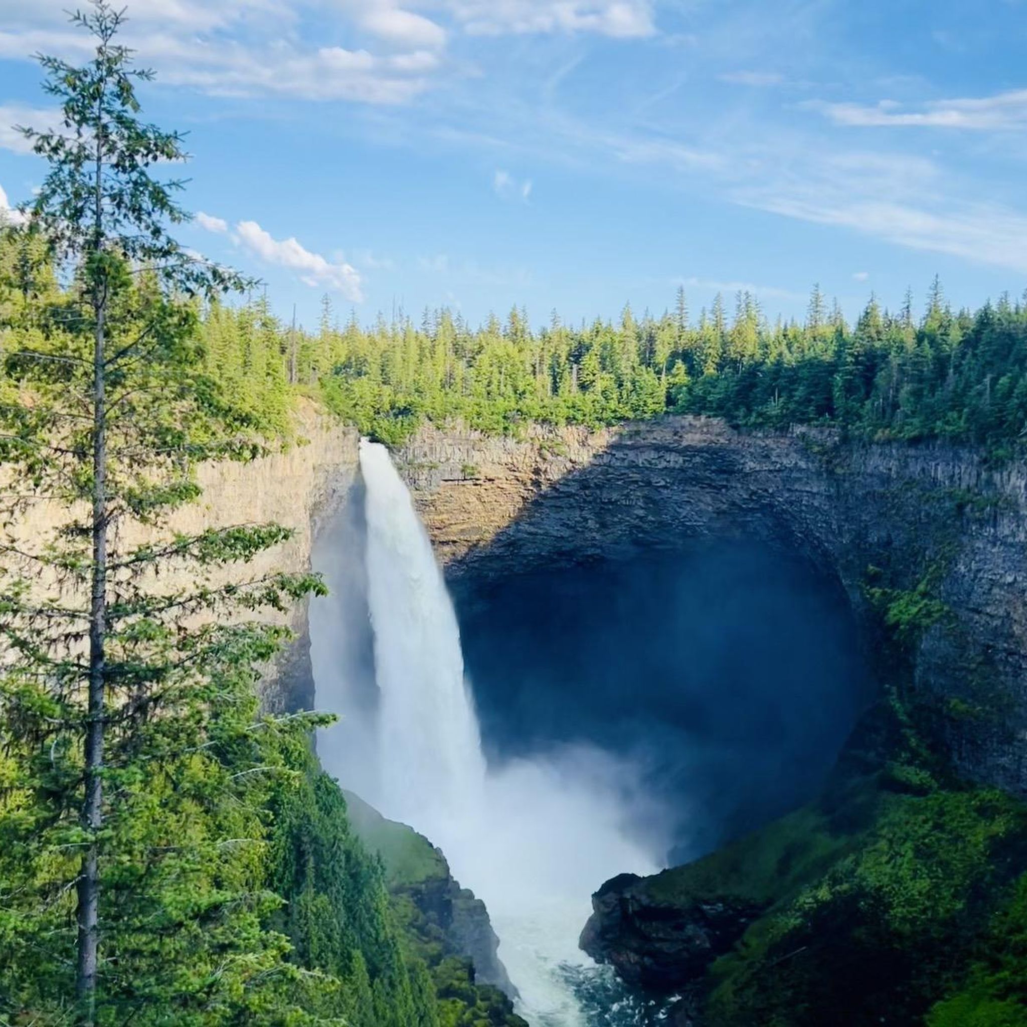
  • Visitors also love Helmcken Falls, a waterfall. This waterfall drops 141 meters from the Murtle Plateau, making it one of the highest waterfalls in Canada.
  • Cariboo Mountains is known for waterfalls, provincial parks, and historic sites. The region offers a variety of natural and cultural attractions to see and explore.
  • The attractions in the Cariboo Mountains are appreciated by the komoot community, with 21 upvotes and 31 photos shared by users.

Last updated: July 6, 2026

Moul Falls

Highlight • Waterfall

Sturdy hiking shoes

Translated by Google •

Tip by

See hikes here

Send to Phone

Save

Spahats Creek Falls

Highlight • Waterfall

Spahats Creek flows west from the Trophy Mountains, crossing the area's basalt formation. Upstream of Spahats Creek Falls, the creek has carved itself into a 23-meter-deep gorge and then plunges over the waterfall 61 meters into a massive canyon, emptying into the Clearwater River a few hundred meters later.
The canyon is the result of glacial meltwater that flowed over the edge of the Clearwater Valley about 11,000 years ago. After the Ice Age, the stream receded into the comparatively small Spahats Creek.
Spahats Creek was once known as Bear Creek. Spahats is a native word for bear.
(Visit June 3, 2018)
worldwaterfalldatabase.com/waterfall/Spahats-Creek-Falls-2293

Tip by

Save

Sign up now to discover places like this

Get recommendations on the best single tracks, peaks, & plenty of other exciting outdoor places.

Sign up for free

Helmcken Falls

Highlight • Waterfall

“Helmcken Falls is the centerpiece to Wells Gray Provincial Park, one of the most powerful waterfalls on earth and one of BC’s prime tourist draws. The Murtle River, which is just a few kilometers upstream, drops over 300 foot (91 m) wide Dawson Falls, narrows to about 75 feet (23 m) wide and surges over the lip of Helmcken Canyon, hurtling 462 feet (141 m) into one of the largest river-sculpted amphitheaters in North America. The bowl behind the falls recedes over 150 feet (46 m) into the cliff and stretches over 500 feet (152 m) wide. Just downstream lies a 50 foot (15 m) lower tier which isn’t usually counted in the total height of the falls but legitimately boosts this to a 500 foot (152 m) tall waterfall. Pictures really do not do this waterfall justice, as there is no way to convey the true power and volume of water spilling off the cliff.”
(Visit June 3, 2018)
worldwaterfalldatabase.com/waterfall/Helmcken-Falls-2303

Tip by

Save

Dawson Falls

Highlight • Waterfall

From the Dawson Falls parking lot, a trail along the Murtle River takes you to the Falls in about 10 minutes. About two-thirds of the way, there is an excellent viewing point for the Falls. The water of the Murtle River plunges about 18 meters down a step at Dawson Falls. If you're lucky, you can see a rainbow below the Dawson Falls.
Opposite is another observation point; it can be reached from the Pyramid Campground.
In addition to Dawson Falls, there are six other waterfalls along the Murtle River in Wells Gray Park.
(Visit June 3, 2018)
worldwaterfalldatabase.com/waterfall/Dawson-Falls-2305
en.wikipedia.org/wiki/Dawson_Falls

Tip by

Save

View of Helmcken Falls

Highlight • Waterfall

A beautiful waterfall, easily reachable on a trail. Quite lonely!

Showing Translation

Tip by

Save

The Mushbowl

Highlight • Waterfall

The Mushbowl is a waterfall on the Murtle River and is located between the Dawson Falls and the Helmcken Falls. At the Mushbowl, the riverbed is narrowed by rocks in the middle and on the side. When the river is low, you can get a good view of the waterfall from a cave that is then accessible.
(Visit June 3, 2018)
worldwaterfalldatabase.com/waterfall/Mushbowl-The-2304

Tip by

Save

Baileys Chute

Highlight • Waterfall

Nice hike, not strenuous, about 1:45 h

Translated by Google •

Tip by

Save

Murtle River Bridge

Highlight • Bridge

Near the Dawson Falls parking lot, the Clearwater Valley Road crosses the Myrtle River on a single-lane steel bridge. A few hundred meters after the bridge, there is a turnoff onto Helmcken Falls Road to the famous waterfalls of the same name.
(Visit June 3, 2018)

Tip by

Save

Triple Decker Falls

Highlight • Waterfall

Triple Decker Falls is a three-tiered waterfall, cascading roughly 60 meters over volcanic rock into a pool at the bottom. The forest around the falls is dense, and the trail is easily accessible from Clearwater Valley Road. After heavy rain, the falls will flow more strongly, but be careful on the trail, as it can get slippery.

Tip by

Save

Dutch Lake Resort & Campground

Highlight • Rest Area

very nice campsite

Translated by Google •

Tip by

Save

Sign up for free to discover even more attractions in the Cariboo Mountains.

Sign up for free

Already have an account?

Start today with a free account

Your next adventure awaits.

Login or Signup

Popular around Cariboo Mountains

Hiking in the Cariboo Mountains

Running Trails in the Cariboo Mountains

Tips from the Community

Fietes
June 13, 2026, Moul Falls

Simply spectacular. The short hike of just under 3km is easily manageable. The descent to the foot of the waterfall is a bit more challenging because the stones are partly very slippery. But you will be rewarded.

Translated by Google

0

0

At over 140 metres tall, it's easy to see why Helmcken Falls was one of the main reasons for the formation of Wells Gray Provincial Park. While the spectacular waterfall is a main draw during the busy summer season, the area is also popular with ice climbers during winter and the falls are known as the "Yosemite of ice climbing".

1

0

Alex
February 24, 2026, Triple Decker Falls

Triple Decker Falls is a three-tiered waterfall, cascading roughly 60 meters over volcanic rock into a pool at the bottom. The forest around the falls is dense, and the trail is easily accessible from Clearwater Valley Road. After heavy rain, the falls will flow more strongly, but be careful on the trail, as it can get slippery.

1

0

A tough climb, but really cool.

Translated by Google

3

0

So incredibly cool! You don't want to miss this.

Translated by Google

3

0

Liecht
August 25, 2025, Baileys Chute

The road to the parking lot from Helmcken Falls is quite bumpy, with lots of potholes, etc. It's no problem with a pickup truck or SUV, and doable with a regular car, but you do have to be a bit careful. The "flying" fish are worth it, though.

Translated by Google

0

0

Kressi
August 5, 2025, Helmcken Falls

The height is impressive

Translated by Google

0

0

Hubert Trapp
February 16, 2025, Dawson Falls

From the Dawson Falls parking lot, a trail along the Murtle River takes you to the Falls in about 10 minutes. About two-thirds of the way, there is an excellent viewing point for the Falls. The water of the Murtle River plunges about 18 meters down a step at Dawson Falls. If you're lucky, you can see a rainbow below the Dawson Falls. Opposite is another observation point; it can be reached from the Pyramid Campground. In addition to Dawson Falls, there are six other waterfalls along the Murtle River in Wells Gray Park. (Visit June 3, 2018) https://www.worldwaterfalldatabase.com/waterfall/Dawson-Falls-2305 https://en.wikipedia.org/wiki/Dawson_Falls

2

0

Frequently Asked Questions

What natural features are prominent in the Cariboo Mountains?

The Cariboo Mountains are rich in natural beauty, featuring expansive provincial parks, towering peaks, and numerous waterfalls. Key natural attractions include Helmcken Falls, Spahats Creek Falls, and Moul Falls, all located within Wells Gray Provincial Park. Other significant areas are Cariboo Mountains Provincial Park, Bowron Lake Provincial Park, and Quesnel Lake, known for its depth and sockeye salmon runs.

What historical sites can I visit in the Cariboo Mountains region?

The region is steeped in history, particularly from the Cariboo Gold Rush era. You can explore Barkerville Historic Town & Park, which recreates the 1860s gold rush with over 125 heritage buildings. Other historical points of interest include the Cariboo Waggon Road, Quesnel Forks, and the 108 Mile Heritage Site.

Are there family-friendly attractions in the Cariboo Mountains?

Yes, many attractions are suitable for families. Waterfalls like Spahats Creek Falls and Dawson Falls offer easy access and viewing platforms. Barkerville Historic Town & Park provides an interactive historical experience for all ages, with shows, gold panning, and heritage buildings. Additionally, many provincial parks offer opportunities for easy walks and wildlife viewing.

What kind of wildlife can I expect to see in the Cariboo Mountains?

The Cariboo Mountains are a true wilderness area, home to abundant wildlife. Visitors might spot grizzly bears, black bears, moose, mountain goats, cougars, and wolves. The region is also a critical habitat for the rare mountain caribou and over 250 species of birds, making it excellent for year-round bird and wildlife viewing.

When is the best time to visit the Cariboo Mountains?

The best time to visit largely depends on your desired activities. Summer (June to September) is ideal for hiking, canoeing, and exploring historical sites, with pleasant weather. Spring and fall offer beautiful scenery and fewer crowds, though some services might be limited. Winter provides opportunities for snow sports at places like Mount Timothy Ski Hill.

What hiking opportunities are available near the attractions?

The Cariboo Mountains offer diverse hiking trails. In Wells Gray Provincial Park, you can hike to waterfalls like Moul Falls or explore the Helmcken Falls Rim Trail. Cariboo Mountains Provincial Park features the 14 km Cameron Ridge Trail with stunning views of Quesnel Lake. For more options, you can find various trails in the Hiking in the Cariboo Mountains guide.

Can I go canoeing or kayaking in the Cariboo Mountains?

Yes, the Cariboo Mountains are renowned for paddling opportunities. Bowron Lake Provincial Park is famous for its multi-day, 116 km canoe circuit across a chain of ten lakes and waterways, offering exceptional wilderness and wildlife viewing. Quesnel Lake also provides a serene experience for canoeing and kayaking.

Are there options for running trails in the Cariboo Mountains?

Yes, there are several running trails available. For example, you can find moderate running loops near Moul Falls and Helmcken Falls. More detailed information and routes can be found in the Running Trails in the Cariboo Mountains guide.

What are some notable waterfalls to visit in the Cariboo Mountains?

The Cariboo Mountains are home to several spectacular waterfalls. Must-see falls include Helmcken Falls, one of Canada's highest, and Spahats Creek Falls, which plunges into a massive canyon. Moul Falls allows visitors to walk behind the cascade, while Dawson Falls and The Mushbowl also offer unique views. You can explore more options in the Waterfall hikes in the Cariboo Mountains guide.

Are there any unique geological formations in the area?

Yes, Pinnacles Provincial Park is home to peculiar rock formations shaped by glacial erosion over millions of years, offering a unique geological sight. The canyons carved by glacial meltwater at places like Spahats Creek Falls also showcase impressive geological processes.

Where can I learn about Indigenous culture in the Cariboo Mountains?

To experience Indigenous culture, you can visit the Xatsull Heritage Village, located on the banks of the Fraser River. It offers insights into the traditions and history of the Secwepemc Nation.

What do visitors enjoy most about the Cariboo Mountains?

Visitors frequently praise the stunning natural beauty, particularly the powerful waterfalls and the vast wilderness. The opportunity for wildlife viewing, the historical immersion at Barkerville, and the extensive hiking and paddling options are also highly valued. The community appreciates the well-maintained trails and the serene, untouched feel of the region.

Most popular routes in the Cariboo Mountains

Hiking in the Cariboo Mountains

Most popular attractions in the Cariboo Mountains

Waterfalls

Store rating

Get inspired with the komoot mobile app

With a free komoot account, you can easily find, customize, and navigate endless outdoor adventures.

or

Join komoot Now

Store rating

Explore more

Still not found the Highlight you’re looking for? See guides of the top attractions in other regions:

Rocky MountainsCoast MountainsArea A (Kicking Horse/Kinbasket Lake)Area C (Pemberton Valley/Mount Currie/D'Arcy)Area D (Elaho/Garibaldi)VancouverAlberni-ClayoquotElectoral Area ABurnabyArea G (Forster Creek/Mount Assiniboine)Vancouver IslandStanley Park National Historic SiteRichmondMetro Vancouver Regional ParksVictoriaSaanichMonashee MountainsArea H (Robson Valley/Canoe)Sunshine Coast Regional DistrictVictoria Harbour Migratory Bird SanctuaryPacific Rim National Park Reserve - Long Beach UnitArea C (Arrowsmith-Benson)Yoho National ParkMount Robson Provincial ParkArea B (Shelter Bay/Mica Creek)East Central Okanagan Electoral AreaArea B (Shawnigan Lake)Cowichan Valley FSelkirk MountainsArea A (Wells Gray Country)SurreyWells Gray Provincial ParkGaribaldi Provincial ParkNorth CowichanMyra-Bellevue Provincial ParkKootenay Boundary EDeltaPitt MeadowsArea C (Puntledge/Black Creek)Juan De Fuca Provincial ParkKootenay National ParkArea B (Cayoosh/Pavilion)Area B (Discovery Islands/Mainland Inlets)NanaimoLangleyArea D (Oyster Bay/Buttle Lake)Area F (McConnell Creek/Hatzic Prairie)Area A (Kyuquot/Nootka/Sayward)Area E (Naramata/Greyback)Area F (Trout Creek Valley)Okanagan-Similkameen DMaple RidgeArea C (Sasquatch Country)Central SaanichArea B (South Fraser Canyon/Sunshine Valley)Area H (Canim Lake/Forest Grove)Area F (Alberni Highway)Area P (Rivers and the Peaks)Area E (Chilliwack River Valley)Area H (Lighthouse Country)Lower Seymour Conservation ReserveStrathcona Provincial ParkCapital GCentral Okanagan JMount Assiniboine Provincial ParkArea J (Copper Desert Country)Area F (Columbia Lake/Windermere Lake)Fraser Valley DArea A (Upper Flathead/Elk Valley)E.C. Manning Provincial ParkPacific Spirit Regional ParkFraser River Delta -- RamsarArea H (Manning Park/Tulameen/Siwash)AbbotsfordNorth SaanichCypress Provincial ParkPurcell MountainsMount Revelstoke National ParkArea L (Grasslands)Area E (Eagle River Valley)Elk Falls Provincial ParkBurnaby Mountain Conservation AreaPacific Rim National Park Reserve - West Coast Trail UnitNanaimo EArea A (Baynes Sound)Area O (Lower North Thompson)Nanaimo GComox Valley B (Lazo North)Cowichan Valley GJoffre Lakes Provincial ParkArea C (Blind Bay/Sorrento)Area C (Inkaneep/Willowbrook)Brandywine Falls Provincial ParkAlice Lake Provincial ParkArea A (Osoyoos Lake)Stikine RegionStawamus Chief Provincial ParkArea D (Trinity/West Creighton)Area C (Moyie/Bull River)Area D (Lardeau Valley/Duncan Lake)Area B (Quatsino Sound/Cape Scott)Area E (Balfour/Cottonwood Lake)Area F (Grindrod/Ashton Creek/Mabel Lake)Area A (Malaspina/Toba)Area A (Wynndel/Crawford Bay/Riondel)Area G (Deroche/Dewdney/Sumas Mountain)Area B (Lake Koocanusa)North Okanagan BArea C (Lois Lake/Saltery Bay)Salt Spring Island Electoral AreaTəmtəmíxʷtən/Belcarra Regional ParkCape Scott Provincial ParkOkanagan LakeArea B (Paradise Valley)Nairn Falls Provincial ParkArea H (The Slocan Valley)Hazelton MountainsArea D (Kiskatinaw Valley)Area J (Lower Arrow/Columbia)Area I (Youbou / Meade Creek)Area G (Salmo Valley)Area A (Upper Bridge River Valley)Cowichan River Provincial ParkArea B (Lower Columbia/Old Glory)Area G (Upper Similkameen/Hedley)Area D (Falkland/Silver Creek)Whistler Interpretive ForestSx̱Ótsaqel / Chilliwack Lake Provincial ParkArea C (Chilako River/Nechako)Area E (Moberly Lake/Sukunka Valley)Area N (Beautiful Nicola Valley - South)Area B (Cawston/Lower Similkameen)Capilano WatershedMount Seymour Provincial ParkArea F (Willow River/Upper Fraser)South Chilcotin Mountains Provincial ParkNorthern RockiesPitt LakeArea F (Scotch Creek/Seymour Arm)Burnaby Lake Regional ParkArea D (Nimpkish Valley/Cormorant Island)Goldstream Provincial ParkArea K (East Chilcotin)Gowlland Tod Provincial ParkArea I (Blue Sky Country)Malaspina Provincial ParkCoquihalla Summit Recreation AreaCultus Lake Provincial ParkNorth Cowichan Municipal Forest ReserveArea D (Granby Valley)Area A (North Skeena)Tynehead Regional ParkArea C (Christina Lake)

Nearby adventure guides

Things to Do around Clearwater Lake

Natural areas to explore nearby

Things to Do in Marble Range Provincial Park

background

Get ready to conquer new peaks

Sign up for Free

Explore
RoutesRoute plannerFeaturesHikesMTB TrailsRoad cycling routesBikepackingSitemap
Download the app
Follow Us on Socials

© komoot GmbH

Privacy Policy