The best walks and hikes in Antonovich Open Space Preserve
4.7
(44)
344
hikers
54
hikes
Hiking in Antonovich Open Space Preserve offers access to a network of trails within Los Angeles County's natural landscapes. The preserve features varied terrain, including canyons, rolling hills, and areas of natural vegetation. Hikers can expect elevation changes and scenic viewpoints across the open space.
Best hiking trails in Antonovich Open Space Preserve
- The most popular hiking route is East Canyon Trail loop — Santa Clarita Woodlands Park, a 3.7 miles (6.0 km) trail that takes 1 hour 57…
Last updated: June 25, 2026
11.7km
03:42
450m
480m
Hike the moderate 7.2-mile East Canyon to O'Melveny Park Trail for diverse woodlands, an orange grove, and panoramic views from Mission Poin
5
hikers
5.94km
01:57
270m
270m
Hike the East and Rice Canyon Loop, an easy 3.7-mile trail in Santa Clarita Woodlands Park with diverse canyon scenery and views.

Sign up for free
1
hikers
7.92km
02:16
180m
180m
Hike the moderate 4.9-mile Wildwood-Highland Loop Trail through oak woodlands and chaparral, with scenic views in Santa Clarita.
19.6km
06:23
840m
840m
Hike the difficult 12.2-mile Mission Point and O'Melveny Park Loop for 360-degree views and diverse terrain in Michael D. Antonovich Open Sp
5.0
(2)
16
hikers
8.09km
02:33
340m
340m
Moderate hike. Good fitness required. Easily-accessible paths. Suitable for all skill levels.
Get access to more routes and recommendations from other explorers.
Sign up for free
Already have an account?
Our route recommendations are based on thousands of hikes, rides, and runs completed by other people on komoot.
Start today with a free account
Your next adventure awaits.
Login or Signup
Tips from the Community

Steep going up but we'll worth the views at Mission Point. Watch for coyotes. Not too technical. usually dry and exposed trail.
0
0

The entrance to O'Melveny Park has a large sign, so it's hard to miss, and a narrow walkway up to the parking area from here. This park is open every day from 8 a.m. to 6 p.m. There are hiking and mountain bike trails here, as well as restrooms and picnic benches.
0
0

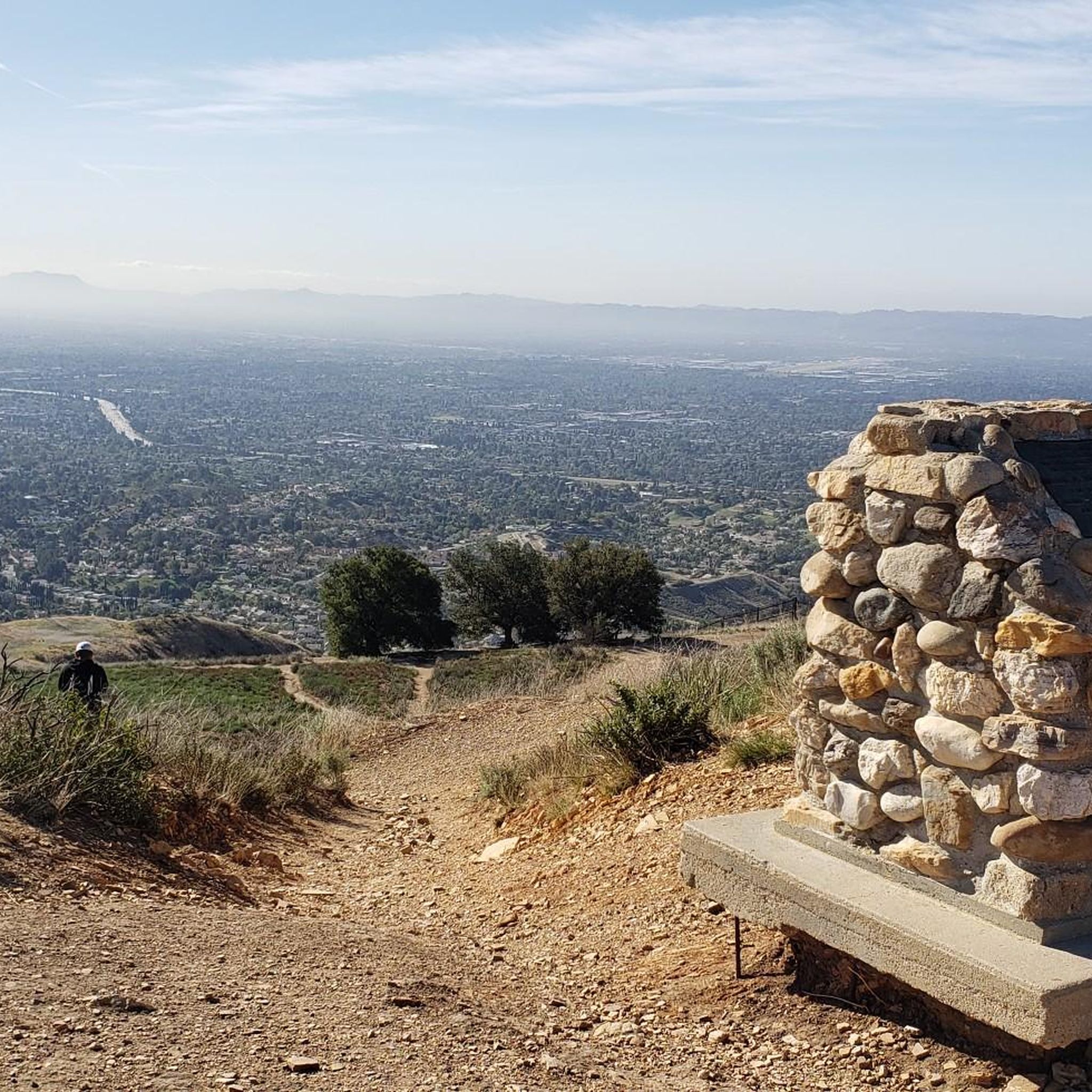
Mission Point is a popular destination for hikers and mountain bikers. The views from the top are spectacular and you can see most of the San Fernando Valley and on a clear day the ocean.
0
0

O'Melveny Park in Granada Hills is a large park, it is the second largest park in Los Angeles County after Griffith Park. It is a great place to hike or run. Having a run out up the O'Melveny Trail up to Mission Point is great fun, not that overcrowded and it has great mountain views.
0
0

The East Canyon Trail follows the double-tracks of an old forest road. Sometimes, you have to jump on a short spur trail to get around some forest fencing, but you never have to trespass or anything. This is an awesome trail for running, but it's definitely a gradual uphill the entire way to Jones Junction and beyond until you turn back for the car.
0
0
Mission Point serves as a lookout and memorial site for Dr. Mario A De Campos. There are great, open views from the top, which can be reached from a couple different directions. The views are of the mountains in one direction and the city in the other.
0
0

The Santa Clarita Woodlands Park is a 4,000 acre public park that links to the Santa Monica Mountains. There are many hiking and mountain biking paths of varying difficulties through the park that offer great views are the nearby area.
1
0
Mission Point is the high point of O’Melveny Park. It offers 360 views of the San Fernando Valley, the Santa Monica Mountains and the San Gabriels.
0
0
Frequently Asked Questions
What kind of hiking trails can I find in Antonovich Open Space Preserve?
Antonovich Open Space Preserve offers a diverse network of trails, ranging from easy walks to more challenging ascents. You'll find routes through canyons, over rolling hills, and amidst natural chaparral vegetation. In total, there are over 40 hiking routes available.
Are there any easy, family-friendly trails in Antonovich Open Space Preserve?
Yes, the preserve has a good selection of easy trails suitable for families. For instance, the East Canyon Trail loop — Santa Clarita Woodlands Park is an easy 3.7-mile (6.0 km) route that offers a gentle introduction to the area's natural features.
What is the typical terrain and elevation gain like in Antonovich Open Space Preserve?
The terrain in Antonovich Open Space Preserve is varied, featuring canyons, rolling hills, and areas of natural vegetation. Hikers can expect elevation changes throughout the preserve. For example, the moderate Highland Loop Trail — Wildwood Canyon Open Space involves about 185 meters of elevation gain.
Are there any loop trails available for hiking in the preserve?
Yes, several loop trails are available, offering convenient circular routes. A popular option is the East Canyon Trail loop — Santa Clarita Woodlands Park, which is an easy 3.7-mile (6.0 km) loop. Another moderate choice is the Mission Point Trail loop — O'Melveny Park.
What are the best times of year to hike in Antonovich Open Space Preserve?
The best times to hike are typically during the cooler months, from late fall through spring (October to May), when temperatures are more moderate. Summer can be very hot, so early morning or late afternoon hikes are recommended if visiting then.
What do other hikers enjoy most about Antonovich Open Space Preserve?
The area is highly rated by the komoot community, with an average score of 4.7 stars from over 30 reviews. Reviewers often praise the diverse terrain, scenic viewpoints, and the sense of natural escape within Los Angeles County.
Are dogs allowed on the trails in Antonovich Open Space Preserve?
Generally, dogs are permitted on trails in Los Angeles County open spaces, including Antonovich Open Space Preserve, but they must be kept on a leash. Always check specific trail signage for any restrictions before heading out with your pet.
Where can I find parking for Antonovich Open Space Preserve trails?
Parking is typically available at various trailheads and access points around the preserve. Specific parking information can often be found on individual route descriptions on komoot or by checking the official Los Angeles County Parks and Recreation website for detailed access points.
Are there any challenging hikes for experienced hikers?
Yes, for those seeking a more strenuous experience, there are challenging routes available. The East Canyon Trail to O'Melveny Park — Antonovich Open Space Preserve is a difficult 12.2-mile (19.6 km) trail with significant elevation changes, often taking over 6 hours to complete.
How can I navigate the trails and ensure I stay on the correct path?
Komoot provides detailed maps and turn-by-turn navigation for all routes within Antonovich Open Space Preserve. You can download tours for offline use, ensuring you have access to your route even without mobile reception.
What kind of wildlife might I encounter in Antonovich Open Space Preserve?
Antonovich Open Space Preserve is home to various wildlife typical of Southern California chaparral and canyon environments. Hikers might spot birds of prey, smaller mammals like rabbits and coyotes, and various reptiles. Always observe wildlife from a distance and do not feed animals.
Most popular routes in Antonovich Open Space Preserve

Get inspired with the komoot mobile app


Explore more
Browse the best Hikes in other regions.
