The best walks and hikes in Friðland Að Fjallabaki
4.7
(635)
5,445
hikers
34
hikes
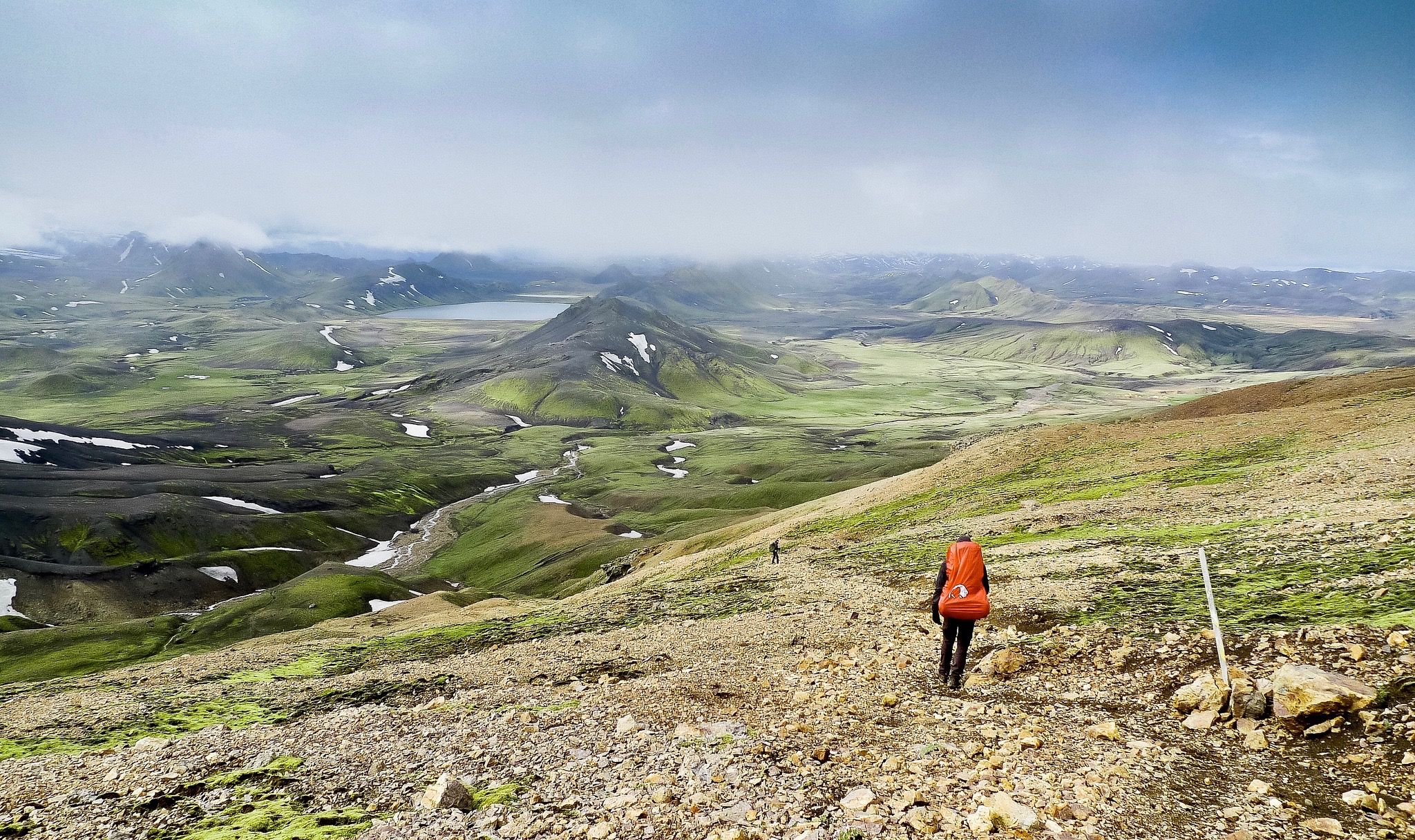
Hiking trails in Friðland Að Fjallabaki traverse a landscape characterized by colorful rhyolite mountains, extensive lava fields, and active geothermal areas. This nature reserve in the southern highlands of Iceland features diverse volcanic terrain, including black sands, craters, and obsidian flows. Hikers encounter deep valleys, clear rivers, and views of glaciers, with vegetation like moss and lichen adding touches of green.
Best hiking trails in Friðland Að Fjallabaki
- The most popular hiking route is View over Landmannalaugar – View of…
Last updated: October 2, 2026
4.9
(205)
1,604
hikers
Hard hike. Good fitness required. Sure-footedness, sturdy shoes and alpine experience required.
4.8
(198)
1,566
hikers
5.98km
01:58
130m
130m
Hard hike. Great for any fitness level. Sure-footedness, sturdy shoes and alpine experience required.

4.9
(93)
754
hikers
6.35km
02:47
280m
280m
Hard hike. Good fitness required. Sure-footedness, sturdy shoes and alpine experience required.
4.8
(13)
119
hikers
Hard hike. Good fitness required. Sure-footedness, sturdy shoes and alpine experience required.
4.9
(18)
160
hikers
12.2km
04:24
380m
380m
Hard hike. Good fitness required. Sure-footedness, sturdy shoes and alpine experience required.
Get access to more routes and recommendations from other explorers.
Already have an account?
Our route recommendations are based on thousands of hikes, rides, and runs completed by other people on komoot.
Start today with a free account
Your next adventure awaits.
Popular around Friðland Að Fjallabaki

Other adventures in Friðland Að Fjallabaki


Tips from the Community

The best-stocked shop on the route
0
0

Not only do the mountains around Landmannalaugar shimmer in bright colors, but stones of all shades can also be found in this valley. The valley is crossed before the ascent to Blahnukur. A small river further enriches the colorful backdrop at the foot of Blahnukur.
0
0

Both tributaries are very hot, but the water cools down considerably after a few meters. Very crowded! No changing rooms: you have to make do with the towel you brought with you.
0
0
In a large tent you can warm yourself up a bit and enjoy the snacks you brought with you.
1
2
Here you can find warm drinks and simple food.
0
0

Landmannalaugar is always worth a visit and from the top you have a great view of the entire valley.
0
0
Great glacier foothills and a great place to relax for a while (as long as the weather plays along).
0
0

It was a great experience to stand up here and enjoy the view. If you are reasonably fit and motivated, you can manage the climb.
0
0
Frequently Asked Questions
What makes the landscape of Friðland Að Fjallabaki unique for hiking?
Friðland Að Fjallabaki is renowned for its extraordinary natural beauty, characterized by vibrant rhyolite mountains painted in hues of green, blue, pink, red, and yellow. This striking coloration is due to volcanic rocks and geothermal activity. Hikers will also encounter diverse volcanic terrain, including vast lava fields, black sands, craters like Ljótipollur Crater Lake, and numerous hot springs and steam vents.
Are there any easy or moderate hiking trails suitable for beginners in Friðland Að Fjallabaki?
While many trails in Friðland Að Fjallabaki are rated as difficult, there are a few options for less experienced hikers. The region offers 2 easy and 3 moderate routes. For example, the View over Landmannalaugar – View of Bláhnúkur loop from Landmannalaugar is a popular 3.7-mile trail that offers stunning views without extreme difficulty.
What are the most notable geological features or landmarks to see while hiking?
The reserve is rich in geological wonders. Key features include the colorful rhyolite mountains like Bláhnúkur Summit ('Blue Peak') and Brennisteinsalda ('Sulphur Wave'), known for their vivid mineral-stained slopes. You can also explore the Laugahraun lava field, the geothermal area around Landmannalaugar, and the striking Ljótipollur Crater Lake.
Can I find circular hiking routes in Friðland Að Fjallabaki?
Yes, Friðland Að Fjallabaki offers several excellent circular routes. A popular option is the Ljótipollur Crater Lake – Landmannalaugar Campground loop from Landmannalaugar, which is about 11 miles long. Another is the View over Landmannalaugar – View of Bláhnúkur loop from Landmannalaugar, a shorter 3.7-mile loop offering panoramic views.
What is the best time of year to go hiking in Friðland Að Fjallabaki?
The best time to hike in Friðland Að Fjallabaki is typically during the summer months, from late June to early September. During this period, the snow has usually melted, roads are open, and the weather is milder, making trails more accessible and enjoyable. Outside of this window, conditions can be challenging due to snow, ice, and road closures.
Are there any waterfalls or hidden gems to discover in the reserve?
Yes, the region boasts several impressive waterfalls and less-known natural sights. While not directly on every hiking route, nearby attractions include Ófærufoss waterfall in Eldgjá canyon, Rauðufossar, Háifoss, and Granni waterfalls. The picturesque Gjáin valley is another hidden gem offering lush vegetation amidst volcanic landscapes.
What are the typical elevation gains for hikes in Friðland Að Fjallabaki?
Elevation gains vary significantly depending on the trail's difficulty and length. For instance, the View over Landmannalaugar – View of Bláhnúkur loop has an elevation gain of around 144 meters. More challenging routes like the Bláhnúkur Summit loop involve climbs of approximately 279 meters, while the Grænihryggur Ridge loop can reach over 660 meters of ascent.
What amenities are available in or near Landmannalaugar for hikers?
Landmannalaugar serves as a primary hub within the reserve. The Landmannalaugar Campground offers basic facilities, including a mountain hut, toilets, and showers. It's also famous for its natural hot spring pools, known as 'People's Pools,' providing a perfect place to relax after a hike. Limited provisions may be available, but it's advisable to bring your own food and supplies.
What do other hikers enjoy most about hiking in Friðland Að Fjallabaki?
The area is highly rated by the komoot community, with an average score of 4.7 stars from over 480 reviews. Hikers consistently praise the stunning and unique colorful rhyolite mountains, the otherworldly volcanic landscapes, and the opportunity to bathe in natural hot springs. The diverse terrain and panoramic views are frequently highlighted as major draws.
Are there any multi-day hiking trails in Friðland Að Fjallabaki?
Yes, Friðland Að Fjallabaki is the starting point for one of Iceland's most famous multi-day treks, the Laugavegur Trail. This challenging 55-kilometer route typically takes 3-4 days to complete, leading hikers through an incredible variety of landscapes, from colorful mountains and lava fields to lush valleys, ending in Þórsmörk.
Is public transport available to reach Friðland Að Fjallabaki or Landmannalaugar?
Yes, during the summer season (typically late June to early September), specialized bus services operate to Landmannalaugar. These buses are equipped to handle the F-roads (mountain roads) that lead into the reserve. It's essential to check schedules and book in advance, as services are limited and roads can be challenging for regular vehicles.
Are permits required for hiking in Friðland Að Fjallabaki?
Generally, permits are not required for day hikes within Friðland Að Fjallabaki. However, if you plan to stay overnight in mountain huts along multi-day trails like the Laugavegur, reservations and fees are mandatory. It's always wise to check the latest regulations from the Icelandic Environment Agency before your trip.
Most popular routes in Friðland Að Fjallabaki
Most popular attractions in Friðland Að Fjallabaki

Get inspired with the komoot mobile app


Explore more
Browse the best Hikes in other regions.
