The best city hikes and walks around Laacher Lake
4.6
(20073)
81,212
hikers
6
hikes
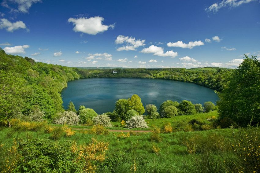
Urban hiking trails around Laacher Lake offer a unique landscape shaped by its volcanic past, featuring a caldera lake and surrounding wooded hills. The region is characterized by subtle reminders of its dormant volcanism, such as mofettes on the eastern shoreline. These trails provide opportunities to explore the largest lake in Rhineland-Palatinate within a designated nature reserve. The terrain generally consists of rolling hills and lakeside paths, suitable for accessible urban exploration.
Best urban hiking trails around Laacher Lake
- The…
Last updated: May 17, 2026
8
hikers
5.27km
01:22
30m
30m
Easy hike. Great for any fitness level. Easily-accessible paths. Suitable for all skill levels.
4.2
(5)
19
hikers
4.21km
01:07
40m
50m
Easy hike. Great for any fitness level. Easily-accessible paths. Suitable for all skill levels.

Sign up for free
5.0
(2)
8
hikers
1.82km
00:28
10m
10m
Easy hike. Great for any fitness level. Easily-accessible paths. Suitable for all skill levels.
5.0
(8)
7
hikers
3.23km
00:51
20m
20m
Easy hike. Great for any fitness level. Easily-accessible paths. Suitable for all skill levels.
2
hikers
5.36km
01:25
50m
50m
Easy hike. Great for any fitness level. Easily-accessible paths. Suitable for all skill levels.
Our route recommendations are based on thousands of hikes, rides, and runs completed by other people on komoot.
Start today with a free account
Your next adventure awaits.
Login or Signup
Popular around Laacher Lake

Tips from the Community

Parking lot if you want to use the Maifeld cycle path from Mayen-Ost.
1
0

The view from here is fantastic. 🥸 On a clear day, you can even see the Feldberg in the Taunus mountains. 👍
0
0

For information about the Silbersee in the Mayen mining area, see e.g. https://www.kuladig.de/Objektansicht/KLD-328392
0
0

Every three years, a symposium with international artists takes place. Stone sculptures made from basalt, the stone quarried in the Mayen mining area, are created there. The unsold pieces can be viewed here.
2
0

neo-Gothic quarry stone hall building, second half of the 19th century
0
0

I walked all the paths in this mining area. It's really worth it. There are explanatory panels everywhere and you can also see many beautiful stone sculptures.
0
0

The mining area is very interesting. The entrance fee for the museum for pensioners is 3.50 euros
1
0

The basalt found here has been used by humans for 7,000 years. It is ideal for making grain graters and millstones. Traces of mining from Roman times and the Middle Ages as well as cranes, tracks and lorries from the 20th century are omnipresent. A circular path winds through the bizarre mining landscape with the Silver Lake, the "Lapidea" sculpture park and the "Bat Tunnel". There, a walk-through shaft takes you into an old mine, where, with a little luck, you can observe the current inhabitants: bats.
1
0
Frequently Asked Questions
How many urban hiking trails are available around Laacher Lake?
There are 6 easy urban hiking trails around Laacher Lake, perfect for a relaxed outing. These routes are generally shorter and have minimal elevation gain, making them accessible for most fitness levels.
Are there any family-friendly urban hikes near Laacher Lake?
Yes, all the urban hikes in this guide are considered easy and suitable for families. For example, the Silbersee (Mayen Mining Area) – Mayen Quarry loop from Mayen is a short 1.8 km walk that explores interesting historical mining areas, which can be engaging for children.
What kind of natural features or landmarks can I expect to see on these urban trails?
While these are urban trails, you can still encounter interesting natural and historical features. The region's volcanic past is evident, and some routes pass by former quarries. You might also find highlights like the Laacher Lake itself, or the Alte Burg Volcanic Rock Face. The Bench by the Insect Hotel loop from Kruft offers a pleasant walk with a focus on local nature.
Are the urban hiking trails around Laacher Lake suitable for dogs?
Generally, dogs are welcome on trails around Laacher Lake. However, it's always best to keep them on a leash, especially in nature reserve areas or when passing through populated sections. Always be mindful of local regulations and other hikers.
What is the typical length and duration of urban hikes in this area?
The urban hikes around Laacher Lake vary in length, but all are relatively short. They range from approximately 1.8 km to 5.5 km. You can expect to complete most of these trails within 1 to 2 hours, making them ideal for a quick stroll or a leisurely afternoon walk. For instance, the Mayen Quarry loop from Mayen is about 4.2 km.
Are there circular urban walks available?
Yes, all the urban hiking trails featured in this guide are circular routes. This means you'll end up back at your starting point without needing to retrace your steps, offering a convenient and enjoyable experience. An example is the Maifeld-Radweg Parking Lot loop from Mayen.
What do other hikers enjoy most about hiking in Laacher Lake?
The area is highly rated by the komoot community, with an average score of 4.6 stars from over 19,000 ratings. Reviewers often praise the well-maintained paths, the serene atmosphere, and the unique geological features. The accessibility of the trails and the blend of nature with historical elements are frequently highlighted.
Is parking available near the urban hiking trails?
Yes, parking is generally available near the starting points of these urban trails, especially in towns like Mayen and Kruft. For example, the Maifeld-Radweg Parking Lot loop from Mayen explicitly mentions a parking lot in its name, indicating convenient access for drivers.
Can I access these urban trails using public transport?
While some trails might be accessible via public transport connections to nearby towns like Mayen, it's advisable to check local bus schedules and routes in advance. Public transport options might be more limited compared to driving, especially for reaching specific trailheads directly.
Are there any cafes or places to eat near the urban hiking routes?
Given the urban nature of these trails, you'll often find cafes, restaurants, and other amenities in the nearby towns such as Mayen or Kruft. These towns provide convenient spots to grab a coffee or a meal before or after your hike.
What is the best time of year for urban hiking around Laacher Lake?
Urban hiking around Laacher Lake is enjoyable year-round. Spring brings blooming nature, summer offers warm weather for leisurely strolls, and autumn provides beautiful foliage. Even in winter, the easy, well-maintained paths can be pleasant for a crisp walk, though checking local conditions is always recommended.
Most popular routes around Laacher Lake
Most popular attractions around Laacher Lake

Get inspired with the komoot mobile app


Explore more
Browse the best Hikes in other regions.
