Easy hikes and walks around Pla D'Urgell
4.5
(100)
962
hikers
128
hikes
Easy hiking trails around Pla D'Urgell traverse a predominantly flat, agricultural landscape characterized by extensive fruit fields and cereal crops. The region is defined by its network of irrigation canals, such as the Canal d'Urgell, which provide dedicated routes for exploration. Natural features include the restored Estany d'Ivars i Vila-sana wetland, offering accessible paths and continuous lake views. Elevated points like the Tossal de la Fita Alta provide panoramic views over the surrounding plains.
Best easy hiking trails around Pla…
Last updated: July 7, 2026
4.6
(27)
188
hikers
5.67km
01:28
30m
30m
Easy hike. Great for any fitness level. Easily-accessible paths. Suitable for all skill levels.
5.0
(2)
12
hikers
7.57km
01:56
20m
20m
Easy hike. Great for any fitness level. Easily-accessible paths. Suitable for all skill levels.

Sign up for free
5
hikers
5.78km
01:38
130m
130m
Easy hike. Great for any fitness level. Easily-accessible paths. Suitable for all skill levels.
7
hikers
5.65km
01:27
20m
20m
Easy hike. Great for any fitness level. Easily-accessible paths. Suitable for all skill levels.
5
hikers
3.11km
00:47
10m
10m
Easy hike. Great for any fitness level. Easily-accessible paths. Suitable for all skill levels.
4
hikers
5.16km
01:19
10m
10m
Easy hike. Great for any fitness level. Easily-accessible paths. Suitable for all skill levels.
4
hikers
4.80km
01:13
10m
10m
Easy hike. Great for any fitness level. Easily-accessible paths. Suitable for all skill levels.
3
hikers
4.84km
01:16
40m
40m
Easy hike. Great for any fitness level. Easily-accessible paths. Suitable for all skill levels.
4
hikers
6.71km
01:47
70m
70m
Easy hike. Great for any fitness level. Easily-accessible paths. Suitable for all skill levels.
3
hikers
Easy hike. Great for any fitness level. Easily-accessible paths. Suitable for all skill levels.
Get access to more routes and recommendations from other explorers.
Sign up for free
Already have an account?
Our route recommendations are based on thousands of hikes, rides, and runs completed by other people on komoot.
Start today with a free account
Your next adventure awaits.
Login or Signup


Tips from the Community

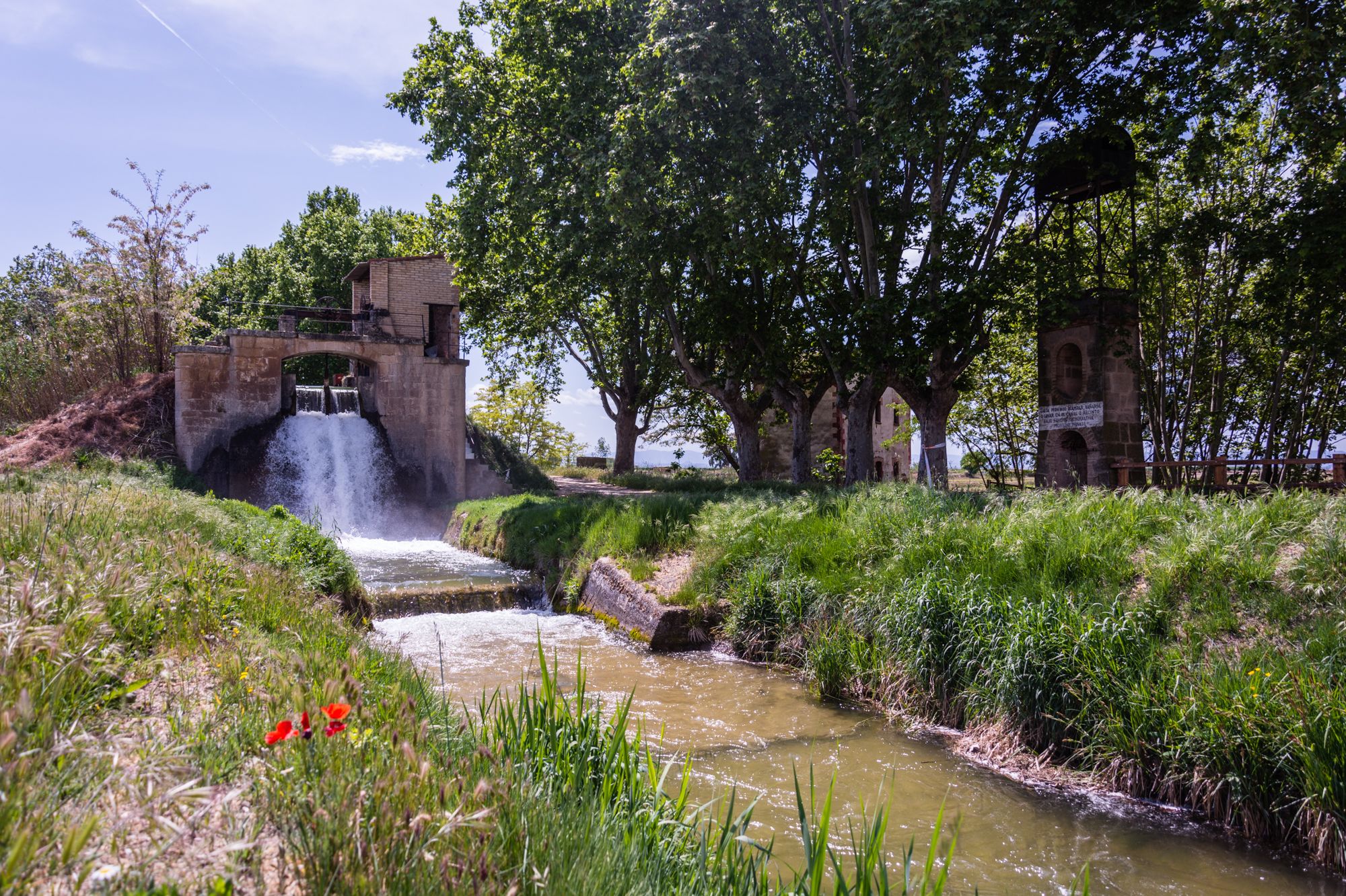
Side path that follows the third ditch of the Canal d'Urgell.
0
0
In the third ditch of the Canal d'Urgell there is this jump which serves to generate a difference in height and force the water. The Canal d'Urgell gives life to the region and has transformed the current landscape.
0
0
Tossal de la Fita Alta, in the Pla d'Urgell, surrounded by fruit fields and with a very good panoramic view of the entire region.
0
0
Historical site, former civil war watchtower, in an elevated position from which there is a very good panoramic view of the entire Pla d'Urgell region.
0
0

The Salto del Durán is a popular hiking destination in the Pla d'Urgell region. It is known for its scenic beauty and offers an intermediate-level hiking trail that covers approximately 8.30 kilometers and takes about two hours to complete.
4
0
The Ruins of San Vicente de Almenara are located in the municipality of Agramunt. This historic site is known for its remains of an ancient Romanesque church dating back to the 11th century. The ruins are located in a picturesque natural setting, ideal for hiking and mountain biking enthusiasts.
5
0
The Pilar de Almenara is a medieval defensive tower located at the top of the Sierra de Almenara, near Agramunt, in the Urgell region of Catalonia. This tower, dating from the 11th and 12th centuries, is 14 meters high and offers stunning panoramic views of the Urgell plain. The tower was used for surveillance and defense against Saracen raids and is similar to other Christian defensive towers in the region. From the top, on clear days, you can see as far as the Seu Vella de Lleida.
8
0

You can see how they defended themselves while admiring an amazing landscape
0
0
Frequently Asked Questions
How many easy hiking trails are available in Pla D'Urgell?
Pla D'Urgell offers a wide selection of easy hiking trails, with over 60 routes specifically categorized as easy. In total, there are 132 hiking routes across various difficulty levels in the region.
What kind of terrain can I expect on easy hikes in Pla D'Urgell?
The easy hikes in Pla D'Urgell primarily traverse a flat, agricultural landscape. You'll find extensive fruit fields, cereal crops, and a network of irrigation canals, such as the Canal d'Urgell. The region also features wetland areas like the Estany d'Ivars i Vila-sana, offering accessible paths and continuous lake views.
Are there any family-friendly easy hikes in Pla D'Urgell?
Yes, Pla D'Urgell is well-suited for family-friendly hikes due to its generally flat and accessible paths. A great option is the Ivars and Vila-sana Pond Loop, which is 3.5 miles (5.7 km) long and offers continuous lake views, perfect for all ages. The Nine Jumps of Juneda Trail is another easy 4.7 miles (7.6 km) path that follows the Canal d'Urgell, showcasing the region's agricultural heritage.
Can I bring my dog on the easy hiking trails in Pla D'Urgell?
While specific regulations can vary, many of the open, agricultural paths and canal routes in Pla D'Urgell are generally suitable for dogs, especially if kept on a leash. Always ensure your dog is under control and respect local signage, particularly around nature reserves or agricultural areas. The flat terrain makes it comfortable for pets.
Are there any easy circular hiking routes in Pla D'Urgell?
Yes, many easy routes in Pla D'Urgell are circular, allowing you to start and end at the same point. Popular options include the Ivars and Vila-sana Pond Loop and the Fita Alta Summit loop from Sidamon. Another good choice is the Banqueta de Juneda loop from Juneda, which is 3.5 miles (5.6 km) long.
What natural attractions can I see on easy hikes in Pla D'Urgell?
Easy hikes in Pla D'Urgell offer views of several natural attractions. The Estany d'Ivars i Vila-sana Pond is a major highlight, a restored wetland perfect for birdwatching. You'll also encounter the extensive network of the Canal d'Urgell, which irrigates the region's agricultural landscapes. For panoramic views, the Fita Alta Summit loop from Sidamon leads to the Tossal de la Fita Alta, an elevated point offering expansive vistas.
Are there any waterfalls accessible on easy trails in Pla D'Urgell?
Yes, the Salt del Duran Waterfall is a notable natural feature in the region. You can access it via the Salt del Durán – Salt del Duran Waterfall loop from Vilanova de Bellpuig, an easy 4.7 miles (7.6 km) route that follows the Canal d'Urgell.
What are the typical durations for easy hikes in Pla D'Urgell?
Easy hikes in Pla D'Urgell typically range from 1 to 2.5 hours. For example, the Ivars and Vila-sana Pond Loop takes about 1 hour 28 minutes, while the Nine Jumps of Juneda Trail is closer to 1 hour 55 minutes. Shorter options like the Third Canal of Urgell Path loop from Mollerussa can be completed in under an hour.
When is the best time of year to go hiking in Pla D'Urgell?
Pla D'Urgell is pleasant for hiking during spring and autumn when temperatures are mild, and the agricultural landscapes are vibrant. Spring brings blooming fruit trees, while autumn offers beautiful colors. Summer can be hot due to the open terrain, so early mornings or late afternoons are recommended if hiking during this season. Winters are generally mild, making it possible to hike year-round, though some paths might be muddy after rain.
What do other hikers enjoy most about the easy trails in Pla D'Urgell?
The easy trails in Pla D'Urgell are highly rated by the komoot community, with an average score of 4.4 stars from over 70 reviews. Hikers often praise the region's flat, accessible paths, the scenic views of the Estany d'Ivars i Vila-sana Pond, and the unique agricultural landscapes along the Canal d'Urgell. The well-maintained routes and opportunities for birdwatching are also frequently highlighted.
Are there any historical points of interest along the easy hiking routes?
Yes, beyond natural beauty, the region offers glimpses into its past. The Tossal de la Fita Alta, accessible via the Fita Alta Summit loop from Sidamon, not only provides panoramic views but also hosts a former Civil War watchtower, adding historical context to your hike.
Are there any easy trails that explore the Canal d'Urgell?
The Canal d'Urgell is a central feature of the region, and many easy trails follow its course. The Third Canal of Urgell Path – Second Bridge loop from Mollerussa is an excellent 4.8 miles (7.8 km) option. Another great choice is the Nine Jumps of Juneda Trail, which highlights the canal's role in the agricultural landscape.
Most popular routes around Pla D'Urgell
Most popular attractions around Pla D'Urgell

Get inspired with the komoot mobile app


Explore more
Browse the best Hikes in other regions.
