The best walks and hikes in Slide Mountain Wilderness
4.6
(96)
1,020
hikers
20
hikes
Hiking in Slide Mountain Wilderness features rugged, mountainous terrain with elevations ranging from 1,100 to 4,180 feet. The region is home to 24 named mountains, including Slide Mountain, the highest peak in the Catskills. Hikers can explore old-growth forests, mixed hardwood valleys, and spruce-fir forests near the peaks, with trails often following regional streams like the Neversink River.
Best hiking trails in Slide Mountain Wilderness
- The most popular hiking route is Panther Mountain Summit via Giant Ledge-Panther Mountain-Fox Hollow Trail — Slide Mountain Wilderness, a 6.2 miles (9.9 km) trail that takes 3 hours 20 minutes to complete. This route offers panoramic views from Giant Ledge and Panther Mountain.
- Another top favourite among local hikers is Giant Ledge #2 via Giant Ledge-Panther Mountain-Fox Hollow Trail — Slide Mountain Wilderness, an easy 3.0 miles (4.8 km) path. This trail leads to the Giant Ledge viewpoint, known for its extensive vistas.
- Local hikers also love the Slide Mountain Summit via Phoenicia East Branch Trail — Slide Mountain Wilderness, a 5.2 miles (8.4 km) trail leading through varied forest, often completed in about 3 hours.
- Hiking in Slide Mountain Wilderness is defined by rugged mountainous terrain, old-growth forests, and unique rock formations. The network offers options for easy, moderate, and difficult ability levels.
- The routes in Slide Mountain Wilderness are highly rated by the komoot community with an average score of 4.6 stars from over 40 reviews. More than 600 hikers have used komoot to explore Slide Mountain Wilderness's varied terrain.
Last updated: July 8, 2026
4.0
(2)
13
hikers
7.09km
04:12
810m
80m
The Wittenberg and Cornell Mountains Trail offers a challenging hiking experience through rugged Catskill terrain. You will cover 4.4 miles (7.1 km) with a significant elevation gain of 2654 feet (809 metres), typically taking around 4 hours and 11 minutes to complete. This difficult route immerses you in diverse forests, from mixed hardwoods to fragrant balsam firs, punctuated by dramatic rock outcroppings. As you ascend, prepare for strenuous sections and rock scrambles, including the famous "Cornell Crack." From the summit of Wittenberg Mountain, you can enjoy panoramic views of the Ashokan Reservoir and the surrounding Catskill peaks.
This trail is considered difficult to very difficult, so plan your visit accordingly. It is popular from spring through fall, offering varied scenery as the seasons change. If you are considering a winter ascent, be aware that specialized gear such as ice axes, snowshoes, and crampons are essential due to the challenging conditions. The route is well-marked with red blazes, helping you navigate the rugged path.
What makes this trail notable is its combination of demanding physical challenge and rewarding natural beauty. Beyond the physical exertion, you will encounter unique geological features and a rich forest ecosystem. The trail is a classic Catskill adventure, known for its raw, untamed feel and the sense of accomplishment it provides. It stands out in the region for its iconic "Cornell Crack" and the expansive vistas from Wittenberg Mountain.
4.0
(1)
11
hikers
19.0km
06:22
600m
600m
The Rocky and Lone Mountain Loop offers a challenging hike through the wild Catskills, covering 11.8 miles (19.0 km) with a significant elevation gain of 1971 feet (601 metres). You should plan for about 6 hours and 22 minutes to complete this difficult route. Expect rugged terrain, including steep ascents and descents through mixed hardwood and dense conifer forests. The trail involves extensive off-trail sections and bushwhacking, immersing you deeply in the wilderness. As you climb, you will cross the Neversink River multiple times, adding to the adventure. Reaching the summits of Lone Mountain and Rocky Mountain rewards you with panoramic views of the surrounding Catskill Mountains and verdant valleys.
Before you set out on this difficult hike, make sure you have strong navigation skills. There are no marked trails between Rocky and Lone Mountains, so a map and compass are essential for staying on course. Be prepared for extensive off-trail sections, which require careful attention to your surroundings. Consider seasonal conditions when planning your visit; winter ascents, for example, demand snowshoes or other traction devices. Always check local weather and trail conditions before heading out.
This route stands out for its deep immersion into the Catskill wilderness, moving from initially marked paths to unmaintained sections. It is a true test of your hiking and navigation abilities, offering a raw and untamed experience. The extensive bushwhacking and river crossings make it distinct from many other trails in the region. If you are seeking a demanding adventure that pushes your limits and rewards you with solitude and expansive views, this loop is an excellent choice.

Sign up for free
8
hikers
4.33km
01:43
520m
0m
Hike the Slide Mountain Out-and-Back, a moderate route that climbs 1693 feet (516 metres) over 2.7 miles (4.3 km). You can expect to complete this journey in about 1 hour and 42 minutes. The trail leads you through varied and rugged terrain, featuring steep, rocky sections and moss-covered ledges as you ascend. You will pass through ancient old-growth forests and dense spruce tunnels, noticing the distinct quartz pebbles beneath your feet. While the very top offers limited views, several overlooks just below the summit, such as the Slide Mountain Overlook, provide sweeping panoramic vistas of the northern Catskills and the Ashokan Reservoir.
If you plan to visit, be aware that camping is restricted above 3,500 feet between March 21 and December 21. Open fires are also prohibited year-round to protect the wilderness. Given the trail's popularity, especially during summer months, arriving early is highly recommended to secure parking at the trailhead. This will help ensure you have a smooth start to your hiking adventure.
This trail takes you to the highest peak in the Catskills, offering a unique opportunity to experience the region's elevated wilderness. It is situated within the Slide Mountain Wilderness, an area known for its pristine natural environment. The journey through old-growth forests and spruce tunnels highlights the distinct ecosystem of this significant Catskill peak.
6
hikers
12.1km
05:03
610m
530m
Embark on the Big Indian and Fir Mountain Loop, a challenging hike that takes you deep into the rugged Big Indian Wilderness of the Catskill Mountains. This difficult route covers 7.5 miles (12.1 km) and involves a significant elevation gain of 1995 feet (608 metres), typically requiring about 5 hours and 3 minutes to complete. You will navigate through dense hemlock and maple forests, encountering steep sections and distinctive rock outcroppings as you ascend towards Fir Mountain.
When planning your visit, be aware that stream crossings along Biscuit Brook can become impassable during periods of high water, so check conditions before you go. While summer offers a lush canopy, consider a winter hike for clearer views through the leafless trees, provided you have the right gear and experience for the conditions. Prepare for a true wilderness experience with sections of bushwhacking, especially between Fir Mountain and Big Indian Mountain.
This loop is a favorite among hikers aiming to complete the Catskill 3500 Club list, offering a demanding yet rewarding journey through a pristine natural environment. The trail provides a raw, untamed experience, making it a notable choice for those seeking a rigorous adventure rather than manicured paths. You will find yourself immersed in the wild, far from the usual crowds.
3
hikers
5.47km
02:30
490m
30m
Hike the Fir Mountain via Pine Hill-West Branch Trail, a moderate 3.4-mile route with 1616 feet of elevation gain in the Big Indian Wilderne
Get access to more routes and recommendations from other explorers.
Sign up for free
Already have an account?
Our route recommendations are based on thousands of hikes, rides, and runs completed by other people on komoot.
Start today with a free account
Your next adventure awaits.
Login or Signup
Popular around Slide Mountain Wilderness
Tips from the Community

First hurdle: crossing (sometimes wading) the Neversink River on the Phoenicia-East Branch Trail... and this can be quite challenging in winter or spring... the trail can be a fast-flowing stream in places, and in winter: sheer ice, perhaps long stretches of snow on ice, quite steep (mostly boulder terrain) but manageable. The summit itself was... well: not impressive, but before the summit there are several viewing platforms with excellent views of the northern Catskills... Slide Mt. is apparently known (though we didn't know that either) because of the naturalist John Burroughs, who discovered Bicknell's thrush here; in any case, there were some spectacular views at certain points.
0
0

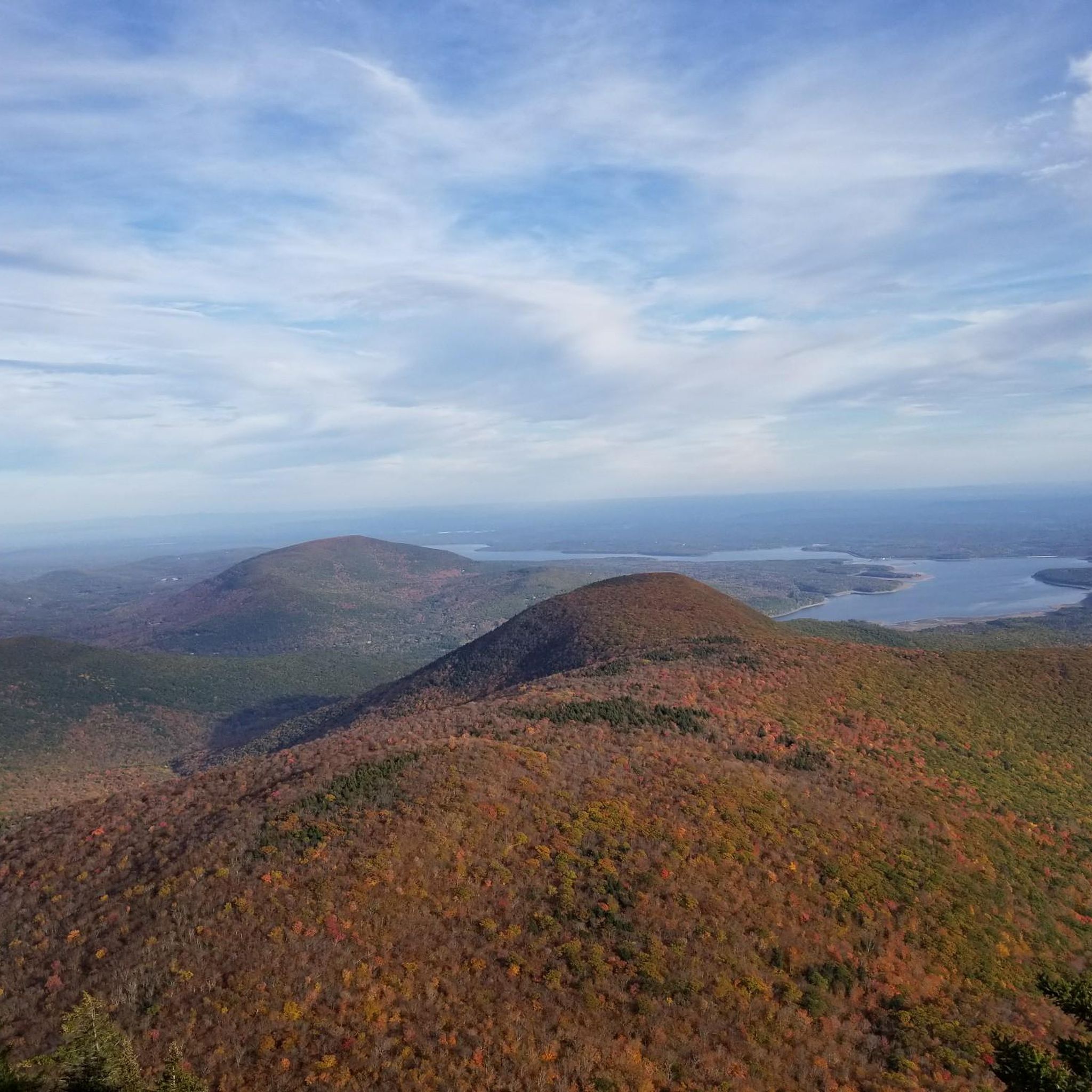
Slide Mountain is the tallest mountain in the Catskills. A few hundred feet past the actual summit, you can enjoy panoramic views from a rocky outcrop. Despite the trees, you'll be able to see the Ashokan Reservoir and part of the Catskill Park.
0
0

Fir Mountain is a 3,620-foot wooded summit with a summit canister at the peak.
0
0
Big Indian's summit, standing at 3,700 feet, ranks as the 19th highest in the Catskills. It is a wooded summit similar to Fir Mountain. You will know you have reached the summit when you find a summit canister at the end of the trail.
0
0

The vistas from Cornell peak have become obscured in recent years as trees have grown and expanded, blocking the sweeping views that once were. However, continuing just a short distance past the peak, there are some really nice viewpoints.
0
0

At 4,204 feet, Slide Mountain is the tallest peak in the Catskills Mountains of New York. It is located within Slide Mountain Wilderness Area and is a very popular hike, for good reason!
0
0
The top of Wittenberg Mountain offers epic views of the Ashokan Reservoir and the surrounding hills. It's the perfect spot for a break!
0
0
Slide Mountain is the tallest mountain in the Catskills. A few hundred feet past the actual summit, you can enjoy panoramic views from a rocky outcrop. Despite the trees, you'll be able to see the Ashokan Reservoir and part of the Catskill Park.
1
0
Frequently Asked Questions
How many hiking trails are available in Slide Mountain Wilderness?
Slide Mountain Wilderness offers a diverse network of 15 hiking trails. These routes cater to various skill levels, ranging from easy strolls to challenging ascents, allowing you to explore the rugged terrain and natural beauty of the Catskills.
What are the different difficulty levels for hiking in Slide Mountain Wilderness?
The trails in Slide Mountain Wilderness are categorized into various difficulty levels. You'll find 2 easy routes perfect for a relaxed outing, 7 moderate trails offering a good challenge, and 6 difficult treks for experienced hikers seeking a strenuous adventure.
When is the best time of year to hike in Slide Mountain Wilderness?
The Slide Mountain Wilderness is a year-round destination. Spring brings lush greenery and flowing streams, while summer offers warm weather for longer treks. Autumn is particularly popular for its vibrant fall foliage. Winter provides opportunities for cross-country skiing and snowshoeing, though trails can be challenging with snow and ice.
Are there any notable viewpoints or landmarks to see while hiking?
Yes, the wilderness is renowned for its spectacular views. Hikers can enjoy panoramic vistas from Giant Ledge Viewpoint, Wittenberg Mountain, and Peekamoose Mountain, which offers views of the Hudson River on clear days. The Slide Mountain Overlook also provides extensive views, including the Ashokan Reservoir.
Can I find old-growth forests or unique geological features on the trails?
Absolutely. The wilderness is home to rich forest ecosystems, including old-growth forests with some trees predating the United States, and one of the largest groves of old-growth hemlocks in the Catskills. You'll also encounter unique geological formations like challenging rock scrambles, a rock chasm, and distinctive spruce tunnels along many trails.
Are there family-friendly hiking options in Slide Mountain Wilderness?
Yes, there are several options suitable for families. An easy path like Giant Ledge #2 via Giant Ledge-Panther Mountain-Fox Hollow Trail is a great choice, leading to the Giant Ledge viewpoint with extensive vistas that can be enjoyed by all ages.
Can I bring my dog on the trails in Slide Mountain Wilderness?
Yes, dogs are generally permitted on trails in the Slide Mountain Wilderness. However, it's crucial to keep them on a leash and practice Leave No Trace principles, including packing out all waste. Always check for any specific trail regulations or seasonal restrictions before heading out.
Are there any circular hiking routes available?
Yes, for those who prefer loop trails, the Slide Mountain Summit via Trailblazer Memorial loop is a popular option. This moderate 9.9 km (6.2 miles) route offers a varied experience as it ascends to the highest peak in the Catskills.
What are some challenging hikes for experienced trekkers?
For experienced hikers seeking a challenge, the Cornell & Wittenberg Mountain from Woodland Valley is a difficult 13.9 km (8.6 miles) route that covers significant elevation gain and offers rewarding views. The Burroughs Range Trail, which traverses Wittenberg, Cornell, and Slide Mountains, is also known for its challenging multi-mountain experience.
Is public transport available to reach the trailheads?
Public transport options directly to all trailheads in the Slide Mountain Wilderness are limited. It is generally recommended to travel by car to access most starting points. Some local shuttle services or taxis might be available from nearby towns, but these should be researched in advance.
Where can I find parking for the hiking trails?
Designated parking areas are available at various trailheads throughout the Slide Mountain Wilderness. Popular trailheads like those for Slide Mountain, Giant Ledge, and Panther Mountain typically have parking lots. It's advisable to arrive early, especially on weekends and during peak seasons, as spaces can fill up quickly.
Are permits required for hiking or camping in Slide Mountain Wilderness?
Generally, permits are not required for day hiking in the Slide Mountain Wilderness. However, for overnight backpacking and camping, specific regulations apply, and primitive campsites or backpackers' shelters are available. Dispersed camping is also permitted under certain guidelines. Always check the latest regulations from the New York State Department of Environmental Conservation (DEC) before your trip.
What do other hikers enjoy most about the trails in Slide Mountain Wilderness?
The trails in Slide Mountain Wilderness are highly rated by the komoot community, with an average score of 4.6 stars from over 40 reviews. Hikers often praise the spectacular panoramic views from summits and ledges, the beauty of the old-growth forests, and the diverse range of trail difficulties that cater to all levels of experience.
Most popular routes in Slide Mountain Wilderness
Most popular attractions in Slide Mountain Wilderness

Get inspired with the komoot mobile app


Explore more
Browse the best Hikes in other regions.
