The best walks and hikes in Warrumbungle National Park
4.8
(18)
320
hikers
8
hikes
Hiking in Warrumbungle National Park offers routes through a landscape shaped by ancient volcanic activity, featuring dramatic spires, domes, and ridges. The park is characterized by its unique geological formations, including the prominent Breadknife and Mount Exmouth. These features create a varied terrain for outdoor activities, ranging from gentle walks to challenging climbs.
Best hiking trails in Warrumbungle National Park
- The most popular hiking route is The Pinnacle – Viewpoint loop from Belougery Spring, a 11.6 miles (18.6 km) trail that takes 5 hours 40 minutes to complete. This difficult route offers extensive views of the park's volcanic formations.
- Another top favourite among local hikers is The Pinnacle – Viewpoint loop from Pincham Car Park, a moderate 8.2 miles (13.3 km) path. This trail provides close-up views of the iconic Breadknife and surrounding volcanic peaks.
- Local hikers also love the Fans Horizon Lookout loop from Pincham Car Park, a 2.2 miles (3.6 km) trail leading through varied terrain to a scenic viewpoint, often completed in about 1 hour 13 minutes.
- Hiking in Warrumbungle National Park is defined by volcanic spires, domes, and ridges, offering panoramic vistas across the ancient landscape. The network provides options for different ability levels, from easy strolls to demanding ascents.
- The routes in Warrumbungle National Park are highly rated by the komoot community with an average score of 4.8 stars from over 10 reviews. More than 200 hikers have used komoot to explore Warrumbungle National Park's varied terrain.
Last updated: November 20, 2026
5.0
(8)
108
hikers
13.1km
04:13
530m
530m
Moderate hike. Good fitness required. Easily walkable paths.
5.0
(2)
60
hikers
13.9km
04:27
560m
560m
Moderate hike. Good fitness required. Easily walkable paths.

4.7
(3)
59
hikers
4.39km
02:02
310m
310m
Moderate hike. Good fitness required. Mostly walkable paths. Sure-footedness required.
5.0
(2)
36
hikers
3.53km
01:13
190m
190m
Easy hike. Easily walkable paths.
4.0
(1)
22
hikers
7.08km
02:06
210m
210m
Moderate hike. Good fitness required. Easily walkable paths.
Get access to more routes and recommendations from other explorers.
Already have an account?
Our route recommendations are based on thousands of hikes, rides, and runs completed by other people on komoot.
Start today with a free account
Your next adventure awaits.
Popular around Warrumbungle National Park
Tips from the Community

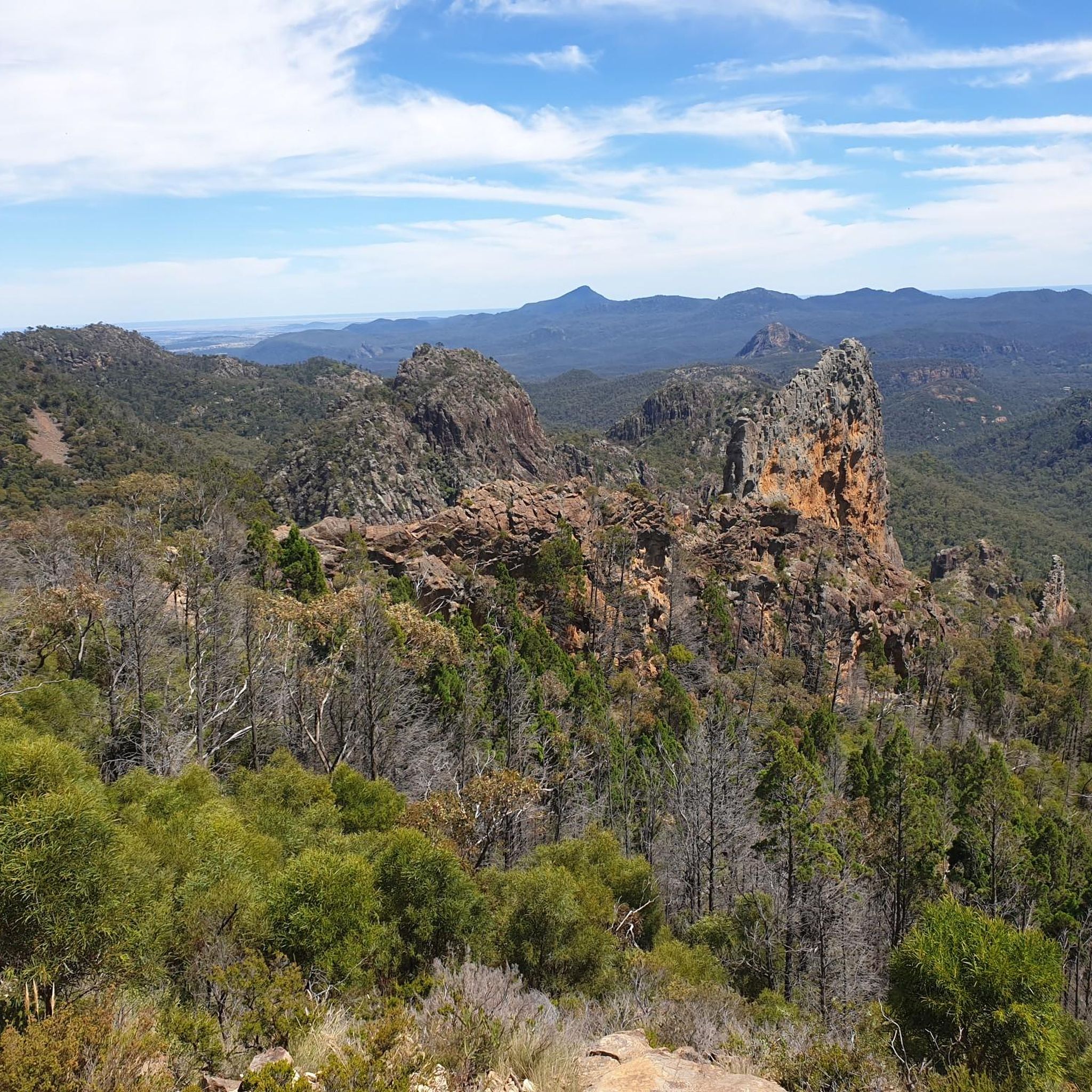
Breadknife and Grand High Tops walk winds into the heart of Warrumbungle National Park, bringing you up close to Belougery Spire, Crater Bluff and The Breadknife. Standing 90 metres tall, The Breadknife is an impressive wall of once-molten volcanic rock, and the views from the high tops are some of the best in NSW. The park lies on Gamilaraay, Wiradjuri and Weilwan Country, and its name comes from a Gamilaraay word meaning “crooked mountain.” In spring, purple hoveas, yellow wattles, white daisy bushes and orange pea flowers line the track, and if you’re lucky, you might spot a wedge-tailed eagle soaring overhead.
0
0
A short scramble up this rocky outcrop on Goulds Circuit walking track opens up to panoramic views across the spires and peaks of the Grand High Tops. Belougery Spire, The Breadknife, and Bluff Mountain are all clearly visible from the top, making Febar Tor a fantastic spot to stop, take in the view, and capture a few photos. The climb is manageable for most walkers, unlike the near-vertical route to the summit of the nearby Macha Tor.
0
0
Spirey View lookout sits about 100 metres off the Breadknife and Grand High Tops walk, and is an easy detour from the main track. From here, The Breadknife and Belougery Spire stand out against the skyline, surrounded by the rugged peaks of the Grand High Tops. With the formations laid out in front of you, it’s a great place to pause and pick out each one before continuing along the route.
0
0
Belougery Split Rock is a unique lava dome in the Warrumbungle Range, on the traditional Country of the Gamilaraay, Wiradjuri, and Weilwan peoples. The summit offers fantastic sweeping 360-degree views over the park’s other major landmarks, including the Breadknife, Grand High Tops, Belougery Spire, and the Siding Spring Observatory. Reaching the top requires some genuine rock scrambling up the final knoll, with steps carved into the rock for the last stretch, but the reward is one of the best panoramas in the Warrumbungles.
0
0
Belougery Split Rock walking track is a moderately challenging route that’s best suited to experienced walkers. The track climbs gradually at first before getting steeper as it works its way up around the base of Split Rock, with a relatively challenging 800-metre out-and-back scramble to the summit itself. Coming back down, the path zigzags along the southern side of the rock to Belougery Creek, where it meets the Burbie Trail for the final stretch back to the car park.
0
0
Burbie Trail, also known as Burbie Canyon walking track, is a wide fire trail that winds through a sandstone gorge in the heart of the Warrumbungles and is a popular route for families and birdwatchers. It offers a gentler, easier alternative to the steeper Split Rock ascent, making it a typical choice for many walkers finishing the loop or as a standalone 2-kilometre return. In the spring, a lovely grove of acacia wattle adds a burst of colour along the way.
0
0

Often considered among the best day hikes in New South Wales, the Breadknife and Grand High Tops Walk takes you through the dramatic volcanic landscape that makes up Warrumbungle National Park. In addition to the stunning rock formations and mountain peaks the area is also bursting with wildlife, especially birds including Peregrine Falcons and the Wedge-Tailed Eagle which is the largest bird of prey in Australia.
0
0
From this point on the track you'll have a great view over the famous Breadknife. This area was once covered by a large shield volcano but as the softer materials eroded away the harder rocks, such as those that make up the Breadknife, were left behind, often in dramatic formations.
0
0
Frequently Asked Questions
What kind of terrain can I expect on hiking trails in Warrumbungle National Park?
Warrumbungle National Park is defined by its dramatic volcanic landscapes. You'll encounter a variety of terrain, from gentle paths along creeks and through sheltered gullies to challenging ascents up volcanic spires, domes, and ridges. Expect stunning geological formations and panoramic views across the ancient landscape.
Are there any easy or family-friendly hiking options in Warrumbungle National Park?
Yes, the park offers several easier walks suitable for families and those seeking a more relaxed pace. Tracks like Tara Cave, Burbie Canyon, and Wambelong follow creeks and sheltered gullies, providing opportunities to spot birdlife and learn about Aboriginal heritage. The Warrumbungle National Park loop from Camp Blackman is another easy option, offering a pleasant 5.8 km stroll.
What are some of the most notable natural features or landmarks to see while hiking?
The park is renowned for its spectacular volcanic formations. Key features include the iconic Breadknife, a towering volcanic dyke, and impressive spires and domes like Crater Bluff, Belougery Spire, and Bluff Mountain. Mount Exmouth is the park's tallest peak, offering expansive views. Many trails, such as The Pinnacle – Viewpoint loop from Pincham Car Park, provide close-up views of these geological wonders.
Are dogs allowed on the hiking trails in Warrumbungle National Park?
No, dogs and other pets are generally not permitted in Warrumbungle National Park to protect the native wildlife and natural environment. This is a common regulation for national parks in Australia.
What is the best time of year to go hiking in Warrumbungle National Park?
The best time to visit Warrumbungle National Park for hiking is typically during autumn (March to May) and spring (September to November). During these seasons, the weather is generally milder and more pleasant for outdoor activities, avoiding the extreme heat of summer and the colder winter mornings.
Are there any circular hiking routes available in the park?
Yes, many of the park's trails are designed as loops, allowing you to experience diverse scenery without retracing your steps. Popular circular routes include The Pinnacle – Viewpoint loop from Belougery Spring, The Pinnacle – Viewpoint loop from Pincham Car Park, and Fans Horizon Lookout loop from Pincham Car Park.
What are the parking facilities like at the trailheads?
Warrumbungle National Park provides designated car parks at key trailheads, such as Pincham Car Park and Camp Blackman. These facilities offer convenient access to many of the popular hiking routes. It's advisable to check the park's official website for any specific parking information or fees.
What makes Warrumbungle National Park unique for outdoor enthusiasts?
Beyond its unique volcanic geology and diverse hiking trails, Warrumbungle National Park is Australia's first Dark Sky Park. This designation means it offers exceptional conditions for stargazing and astronomy due to low light pollution, low humidity, and high altitude, making it a truly special destination for both day and night activities.
What do other hikers enjoy most about hiking in Warrumbungle National Park?
The area is highly rated by the komoot community, with an average score of 4.8 stars from over 10 reviews. Reviewers often praise the spectacular volcanic scenery, the challenging yet rewarding climbs, and the sense of wilderness. The clear night skies for stargazing are also a frequently mentioned highlight.
Are there opportunities to learn about Aboriginal culture in the park?
Yes, Warrumbungle National Park holds significant Aboriginal cultural heritage. The landscape, plants, and animals are spiritually important to the Gamilaraay, Wiradjuri, and Weilwan people. Visitors can explore this heritage, for example, through sites like Tara Cave, which is part of some of the easier walking tracks.
How many hiking trails are there in Warrumbungle National Park?
Warrumbungle National Park offers a variety of hiking experiences, with over 7 distinct routes documented on komoot. These range from easy strolls to challenging multi-hour treks, ensuring options for different fitness levels and interests.
What is the most challenging hike in Warrumbungle National Park?
For experienced hikers, the route to Mount Exmouth offers a demanding adventure with steeper climbs and outstanding views from the 1206-meter summit. Another challenging option is The Pinnacle – Viewpoint loop from Belougery Spring, which covers 18.6 km and involves significant elevation gain.
Most popular routes in Warrumbungle National Park
Most popular attractions in Warrumbungle National Park

Get inspired with the komoot mobile app


Explore more
Browse the best Hikes in other regions.
