The best walks and hikes in Cotacachi
4.7
(127)
795
hikers
11
hikes
Hiking in Cotacachi offers diverse natural landscapes within the Andean highlands of Ecuador. The region is characterized by prominent volcanic features, including the Laguna Cuicocha crater lake and the Cotacachi Volcano, alongside vast ecological reserves. These areas encompass a range of ecosystems, from high-altitude páramo grasslands and cloud forests to significant waterfalls. The varied terrain provides numerous opportunities for outdoor exploration.
Best hiking trails in Cotacachi
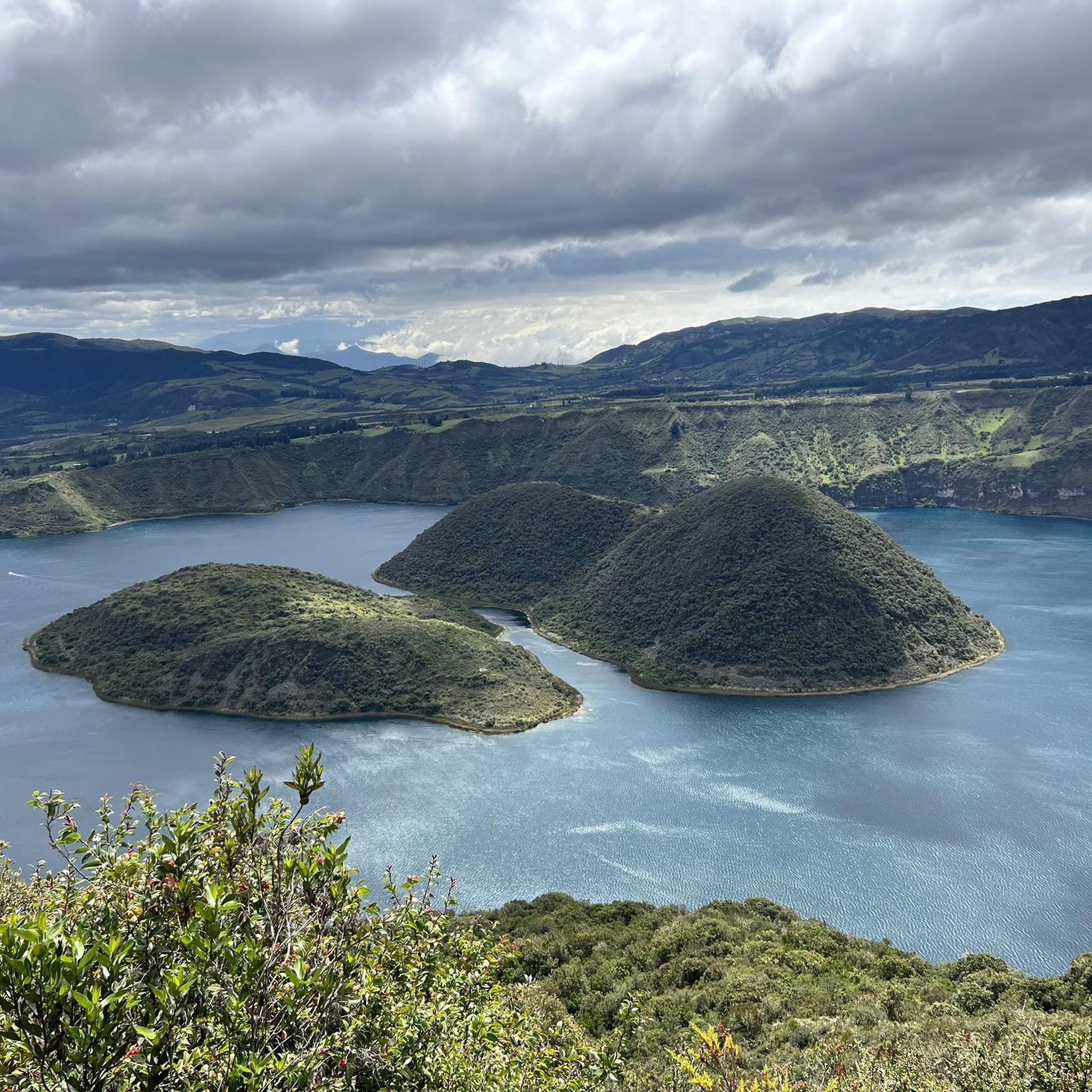
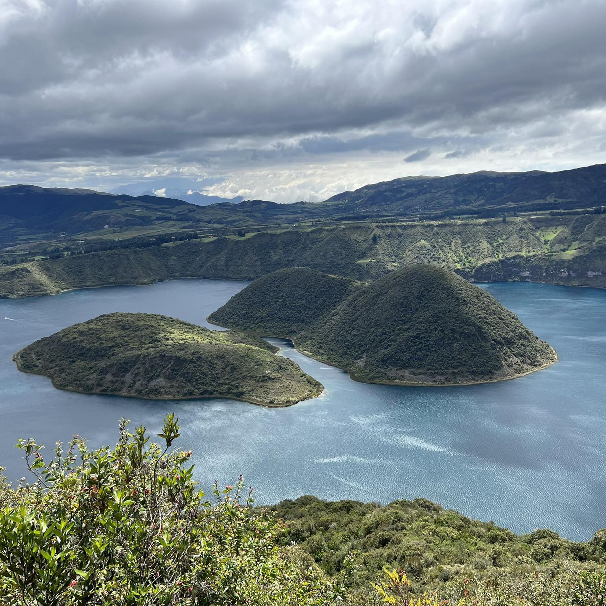
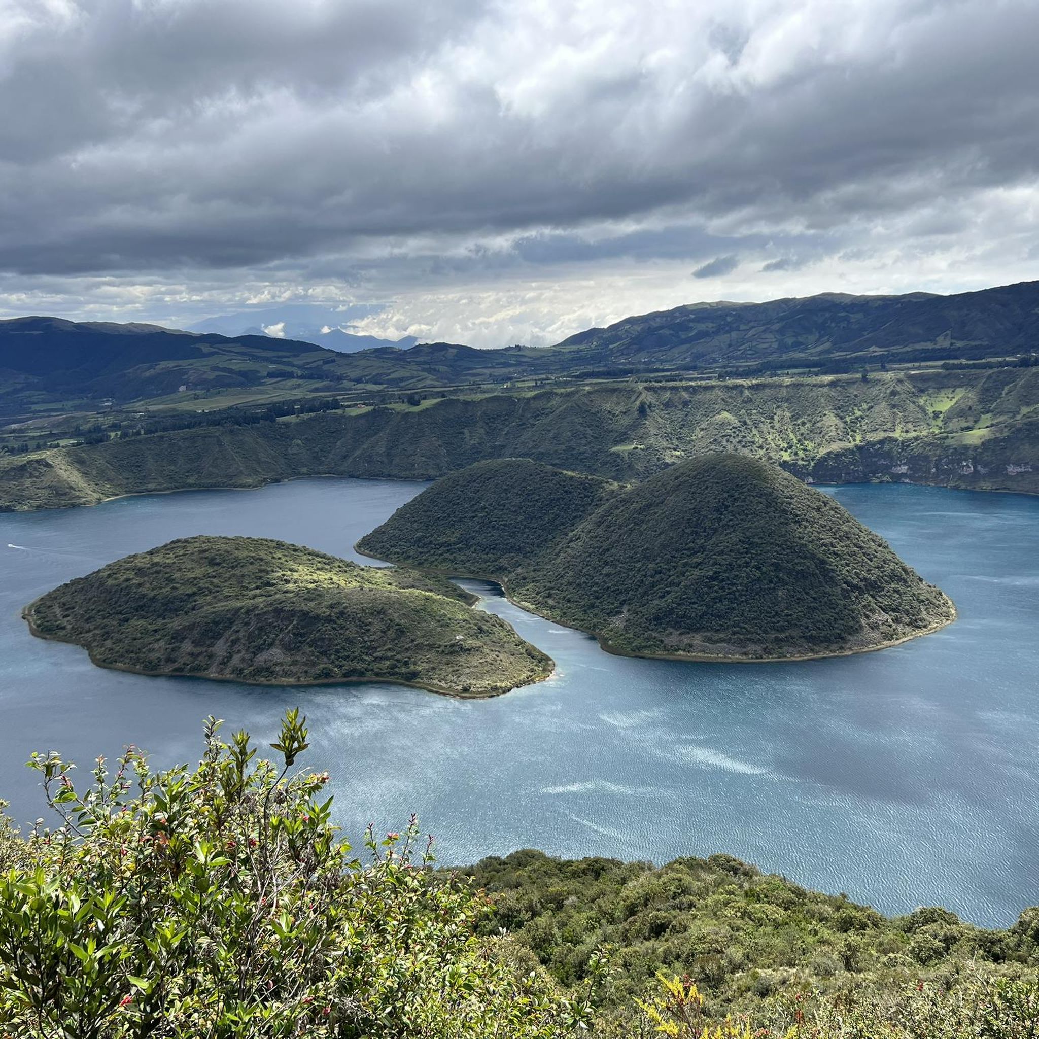
- The most popular hiking route is Cuicocha Lake Trail – View of Lake Cuicocha loop from Parqueadero Laguna Cuicocha, a 7.6 miles (12.3 km) trail that takes 4 hours 2 minutes to complete. This moderate route offers panoramic views of the volcanic crater lake and its islands.
- Another top favourite among local hikers is Cuicocha Crater Lake – Cuicocha Lake Trail loop from Parqueadero Laguna Cuicocha, a moderate 4.6 miles (7.3 km) path. This trail provides closer views of the lake's unique geological formations.
- Local hikers also love the Natural Swimming Pool – Peguche Waterfall loop from Otavalo, a 4.2 miles (6.8 km) trail leading through local landscapes to the sacred Peguche Waterfall, often completed in about 1 hour 57 minutes.
- Hiking in Cotacachi is defined by volcanic crater lakes, extensive ecological reserves, and significant waterfalls. The network offers options for various ability levels, from easy walks to more challenging ascents.
- The routes in Cotacachi are highly rated by the komoot community with an average score of 4.7 stars from over 100 reviews. More than 700 hikers have used komoot to explore Cotacachi's varied terrain.
Last updated: July 11, 2026
4.9
(109)
640
hikers
Moderate hike. Good fitness required. Easily-accessible paths. Suitable for all skill levels.
5.0
(2)
58
hikers
Moderate hike. Good fitness required. Easily-accessible paths. Suitable for all skill levels.

Sign up for free
4.0
(4)
34
hikers
6.82km
01:57
140m
140m
Easy hike. Great for any fitness level. Easily-accessible paths. Suitable for all skill levels.
4.3
(3)
11
hikers
9.67km
02:56
310m
310m
Moderate hike. Good fitness required. Easily-accessible paths. Suitable for all skill levels.
4.7
(3)
15
hikers
12.4km
03:40
330m
330m
Moderate hike. Good fitness required. Easily-accessible paths. Suitable for all skill levels.
Get access to more routes and recommendations from other explorers.
Sign up for free
Already have an account?
Our route recommendations are based on thousands of hikes, rides, and runs completed by other people on komoot.
Start today with a free account
Your next adventure awaits.
Login or Signup
Tips from the Community

Being in this place and having the feeling of turning around and knowing everything you walked, is beautiful. A different view of everything and the most refreshing and delicious breeze there is.
0
0

On this section of the hiking trail that runs all the way around Laguna Cuicocha, after climbing numerous steps and through lush Andean flora, you reach a ridge path with fantastic views of the lagoon and the Otavalo plain
0
0

Look for a sacred place with beautifully landscaped hiking trails. At the top you can crawl through narrow caves and discover other smaller waterfalls. Entrance fees are required.
2
0
Behind the figures at the parking lot there is a sales area of the local indigenous people, where you can also have a drink.
2
0
These are new sculptures that probably belong to the local soccer field and playground across the street. A bench invites you to rest.
2
0
El Lechero is a viewpoint whose tree at the top of the hill is considered sacred. Although unknown to many people, this tranquil spot offers beautiful views of the surrounding area. Located in Otavalo, Ecuador near Condor Park. El Lechero, Otavalo's sacred tree, is part of local mythology and is believed to house the soul of a cursed lover who fell in love with a boy from a rival family. And then it was transformed into nearby Lake San Pablo. From the El Lechero viewpoint you can see Lake San Pablo, the Fuya Fuya Mountains, the Cotacachi Volcanoes, Imbabura and a great view of the city of Otavalo. The place where the tree stands is considered a sacred place with healing powers by local people. There are indigenous Otavaleños who perform many purification rituals and spiritual ceremonies. El Lechero is a place open to the public, where you can not only take beautiful photos, but also have picnics. To get there, you'll have to walk a steep 5km or so from Otavalo or hire a taxi for around $4 each way. There is no transport at the top. Ask the driver to wait if he doesn't want to go back. Source: https://www.planetandes.com/es/ecuador/andes/imbabura/otavalo/el-lechero-arbol-sagrado-otavalo/
2
0
Lake San Pablo or Imbacocha, Spanish Lago San Pablo, Kichwa: Impakucha ("Lake of the Andean Climbing Catfish": impa "Andean Climbing Catfish", kucha "lake") is located in the province of Imbabura in northern Ecuador, at 2,660 m above sea level, below the Imbabura volcano, has a water surface of about 1.8 km² and is of volcanic origin. Source: https://de.wikipedia.org/wiki/Lago_San_Pablo You can take boats across the lake. There are a few stalls at the departure point.
0
0
Frequently Asked Questions
How many hiking trails are available in Cotacachi?
Cotacachi offers a diverse network of over 10 hiking trails, catering to various skill levels. You'll find options ranging from easy walks to more challenging ascents, allowing you to explore the region's unique landscapes.
What is the best time of year for hiking in Cotacachi?
Cotacachi enjoys an 'eternal spring' climate, making it suitable for hiking year-round. While sunny days are common, it's always wise to be prepared for cooler temperatures at higher altitudes. The dry season, typically from June to September, often provides the most stable weather conditions.
What do other hikers enjoy most about hiking in Cotacachi?
The hiking routes in Cotacachi are highly rated by the komoot community, with an average score of 4.7 stars from over 100 reviews. Hikers frequently praise the breathtaking panoramic views, especially around Laguna Cuicocha, and the diverse natural beauty of the region, from volcanic landscapes to lush cloud forests.
Are there any easy hiking trails suitable for beginners in Cotacachi?
Yes, Cotacachi has several easy hiking options. For a relaxed experience, consider the Natural Swimming Pool – Peguche Waterfall loop from Otavalo, which is about 4.2 miles (6.8 km) and takes less than two hours. This trail leads through local landscapes to the sacred Peguche Waterfall.
Can I find circular hiking routes in Cotacachi?
Many of Cotacachi's most popular trails are circular, offering continuous scenic views. A prime example is the Cuicocha Lake Trail – View of Lake Cuicocha loop from Parqueadero Laguna Cuicocha, which provides panoramic views of the volcanic crater lake. Another option is the Cuicocha Crater Lake – Cuicocha Lake Trail loop from Parqueadero Laguna Cuicocha, offering closer views of the lake's unique geological formations.
Are there hiking trails that feature waterfalls in Cotacachi?
Absolutely. The Peguche Waterfall is a significant natural attraction near Cotacachi, and there are accessible trails leading to it. The Natural Swimming Pool – Peguche Waterfall loop from Otavalo is a popular choice for experiencing this sacred site.
What kind of wildlife might I encounter on the trails in Cotacachi?
Hiking in Cotacachi, especially within the Cotacachi-Cayapas Ecological Reserve, offers opportunities to observe diverse wildlife. The reserve is a UNESCO Biosphere Reserve and home to over 700 species of birds, various mammals like the spectacled bear and jaguar, and numerous plant species such as orchids and bromeliads. Keep an eye out for the rich birdlife around Laguna Cuicocha.
What notable natural attractions can I explore while hiking in Cotacachi?
Cotacachi is rich in natural wonders. The most iconic is Laguna Cuicocha, a stunning volcanic crater lake. You can also visit the sacred Peguche Waterfall, or explore the vast Cotacachi-Cayapas Ecological Reserve, which features a Wildflower Path.
Are there any challenging hikes for experienced trekkers?
Yes, for experienced trekkers, the dormant Cotacachi Volcano itself offers a challenging and rewarding climb, rising to 4,939 meters (16,204 feet). While not a komoot route in this guide, trails within the Cotacachi-Cayapas Ecological Reserve also include strenuous treks through high-altitude páramo grasslands.
Is parking available at the trailheads in Cotacachi?
Yes, for popular hiking areas like Laguna Cuicocha, designated parking facilities are available. For instance, routes like the Cuicocha Lake Trail often start from a 'Parqueadero Laguna Cuicocha', indicating available parking at the trailhead.
What should I wear for hiking in Cotacachi's climate?
Given Cotacachi's 'eternal spring' climate and varying altitudes, it's best to dress in layers. Include moisture-wicking base layers, an insulating mid-layer, and a waterproof/windproof outer shell. Comfortable hiking boots are essential, and sun protection (hat, sunglasses, sunscreen) is recommended due to the high altitude.
Are there family-friendly hiking options in Cotacachi?
Many of the easier trails, particularly those around the Peguche Waterfall or shorter sections of the Cuicocha Lake paths, can be suitable for families. These routes often have less elevation gain and offer engaging natural sights for all ages to enjoy.
Are permits required for hiking in Cotacachi?
Generally, permits are not required for most standard hiking trails around Cotacachi, such as the popular routes around Laguna Cuicocha or to Peguche Waterfall. However, if you plan to undertake more challenging expeditions, especially within restricted areas of the Cotacachi-Cayapas Ecological Reserve or attempting summit climbs, it's advisable to check with local authorities or tour operators for any specific requirements.
Most popular routes in Cotacachi
Most popular attractions in Cotacachi

Get inspired with the komoot mobile app


Explore more
Browse the best Hikes in other regions.
