The best walks and hikes around Água De Pena
4.2
(25491)
127,596
hikers
10
hikes
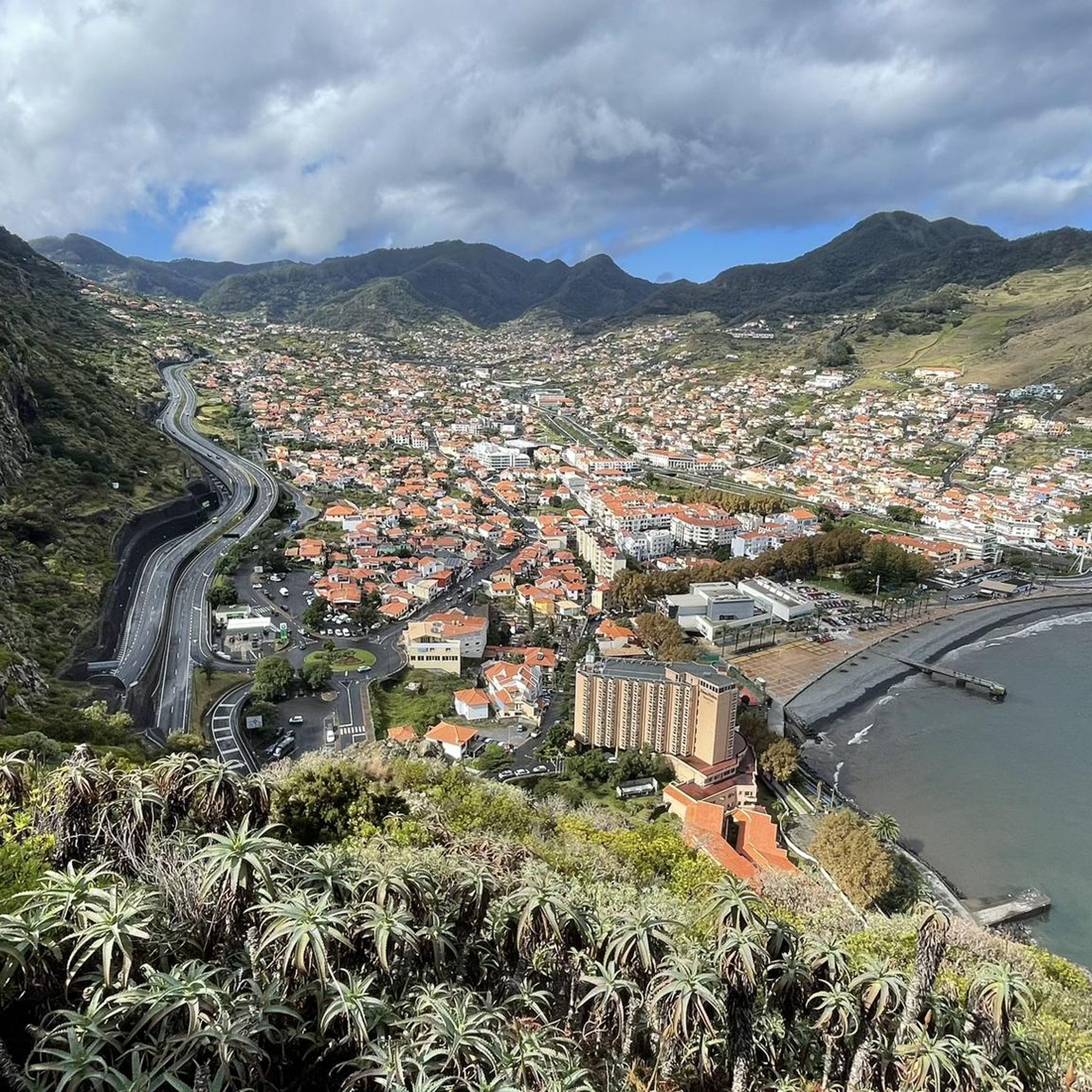
Hiking around Água De Pena, located on Madeira's east coast, offers diverse landscapes for outdoor activities. The region features historic levada trails that wind through lush interior woodlands, providing unique perspectives of the island's flora. Hikers can also find dramatic coastal landscapes with panoramic views of the Atlantic Ocean and rugged cliffs, alongside mountainous terrain offering vistas of Machico and its bay. This varied environment supports a range of hiking experiences, from gentle walks to more challenging paths.
Best hiking…
Last updated: May 23, 2026
4.0
(66)
223
hikers
7.13km
02:15
260m
260m
Moderate hike. Good fitness required. Easily-accessible paths. Suitable for all skill levels.
4.6
(29)
114
hikers
11.7km
03:40
440m
440m
Moderate hike. Good fitness required. Easily-accessible paths. Suitable for all skill levels.

Sign up for free
4.1
(8)
39
hikers
21.8km
07:17
1,000m
990m
Hard hike. Very good fitness required. Mostly accessible paths. Sure-footedness required.
32
hikers
5.02km
01:34
160m
160m
Easy hike. Great for any fitness level. Easily-accessible paths. Suitable for all skill levels.
4.0
(2)
13
hikers
Moderate hike. Good fitness required. Easily-accessible paths. Suitable for all skill levels.
Get access to more routes and recommendations from other explorers.
Sign up for free
Already have an account?
Our route recommendations are based on thousands of hikes, rides, and runs completed by other people on komoot.
Start today with a free account
Your next adventure awaits.
Login or Signup

Tips from the Community


Beautifully embroidered during the flower festival
0
0
Beautiful place with restaurants, sandy beach and delicious ice cream parlor
1
0
Beautiful spots and encountered a total of 3 people. Looking for a quiet walk, here it is.
1
0
Very doable, provided you are not afraid of heights. Descent to the suspension bridge can be somewhat slippery.
1
0
Frequently Asked Questions
How many hiking trails are there in Água De Pena?
Água De Pena offers a selection of 10 hiking trails, catering to various preferences and skill levels. These routes are highly rated by the komoot community, with an average score of 4.2 stars from over 25,000 reviews.
Are there easy hiking trails suitable for beginners or families in Água De Pena?
Yes, Água De Pena has several easy trails perfect for beginners or families. One excellent option is the Machico Sandy Beach – Machico Bay and Marina loop from Machico. This 3.1-mile (5.0 km) route takes about 1 hour 33 minutes and offers pleasant coastal paths and marina views.
Can I find circular hiking routes in Água De Pena?
Absolutely. Many of the trails in Água De Pena are circular, allowing you to start and end at the same point. A popular moderate circular route is the View of Santa Cruz – Levada Nova loop from Água de Pena, which spans 7.4 miles (11.9 km) and offers panoramic coastal views.
What kind of natural features, like waterfalls or viewpoints, can I expect on hikes here?
The region is rich in natural beauty. You'll encounter stunning coastal views of the Atlantic Ocean and dramatic cliffs. The famous *levada* trails often lead through lush landscapes, and some routes in the broader Madeira area are known for waterfalls, such as those found on the Levada do Caldeirão Verde. For impressive vistas, consider trails that offer views of Machico Bay or the imposing Eagle Rock (Penha d'Águia).
Are there any significant landmarks or natural monuments to explore near the trails?
Yes, the area boasts several notable landmarks. The most prominent is Eagle Rock (Penha d'Águia), a striking geological formation nearly 600 meters high, offering challenging hikes and rewarding views. Other peaks like Pico das Pedras Brancas and Eagle Rocks Summit also provide excellent viewpoints.
What do other hikers say about the trails in Água De Pena?
The trails in Água De Pena are highly regarded by the komoot community, holding an average rating of 4.2 stars from over 25,000 reviews. Hikers frequently praise the diverse landscapes, from historic *levada* paths winding through lush woodlands to dramatic coastal routes with panoramic ocean views. The variety of experiences, suitable for different ability levels, is also a common highlight.
Are the hiking trails in Água De Pena suitable for dogs?
While many trails in Madeira are dog-friendly, it's always best to check specific route details and local regulations before heading out with your canine companion. Some protected natural areas or *levada* paths might have restrictions. Ensure your dog is on a leash and you carry waste bags.
What is the best time of year to go hiking in Água De Pena?
Madeira enjoys a mild climate year-round, making hiking possible in any season. However, spring (April to June) and autumn (September to November) often offer the most pleasant conditions with comfortable temperatures and less rainfall. Summer can be warm, especially on exposed coastal paths, while winter brings cooler temperatures and a higher chance of rain, though many days remain suitable for hiking.
Are there any longer or more challenging hikes for experienced trekkers?
Yes, for those seeking a greater challenge, Água De Pena and its surroundings offer more demanding routes. The Levada Nova – Levada Nova loop from Machico is a difficult 13.4-mile (21.5 km) hike that takes over 7 hours to complete, featuring significant elevation changes and immersive *levada* experiences.
Where can I find parking for hiking trails in Água De Pena?
Parking availability varies by trailhead. For routes starting in or near Machico, you can often find public parking areas. For trails like the Levada dos Tornos – Levada Nova loop from Santo António da Serra, parking is typically available near the starting point in the respective villages. It's advisable to check specific route descriptions or use navigation apps for detailed parking information before your hike.
What are the typical durations for hikes in this region?
Hikes in Água De Pena vary significantly in duration. Easy walks, like the Machico Sandy Beach – Machico Bay and Marina loop, can be completed in under 2 hours. Moderate trails, such as the Polícia Vehicle in Madeira – View of the runway at Madeira Airport loop from Machico, typically take 3 to 4 hours. More challenging routes can extend to 7 hours or more, depending on distance and elevation.
Are there any trails that offer coastal views?
Many trails in Água De Pena provide spectacular coastal views. The region's dramatic coastline means you can often enjoy panoramic vistas of the Atlantic Ocean and rugged cliffs. The View of Santa Cruz – Levada Nova loop from Água de Pena is a great example, offering expansive views of the coast and Machico Bay.
What are "levada" trails, and can I hike them in Água De Pena?
Levadas are unique to Madeira; they are man-made irrigation channels that transport water across the island, often with maintenance paths alongside them. These paths have become popular hiking trails, offering calming experiences through lush nature. Yes, Água De Pena is home to several *levada* trails, including sections of Levada dos Tornos and Levada Nova, providing a distinctive way to explore the island's interior.
Most popular attractions around Água De Pena

Get inspired with the komoot mobile app


Explore more
Browse the best Hikes in other regions.
