The best walks and hikes around Vale De Santarém
4.6
(17)
104
hikers
10
hikes
Hiking around Vale De Santarém offers access to the fertile Tagus River valley, characterized by extensive agricultural plains, vineyards, and olive groves. The terrain is generally flat to gently undulating, providing accessible walking opportunities. This region is part of the broader Santarém district, which features diverse landscapes including river systems and wetlands, and is within proximity to limestone massifs. The area provides a blend of natural beauty and rural charm for outdoor exploration.
Best hiking trails in Vale De Santarém
…Last updated: June 24, 2026
6
hikers
7.00km
01:58
140m
140m
Easy hike. Great for any fitness level. Easily-accessible paths. Suitable for all skill levels.
5.0
(2)
11
hikers
Easy hike. Great for any fitness level. Easily-accessible paths. Suitable for all skill levels.

Sign up for free
5.0
(1)
14
hikers
Easy hike. Great for any fitness level. Easily-accessible paths. Suitable for all skill levels.
4
hikers
8.34km
02:15
110m
110m
Moderate hike. Good fitness required. Easily-accessible paths. Suitable for all skill levels.
5.0
(1)
11
hikers
Easy hike. Great for any fitness level. Easily-accessible paths. Suitable for all skill levels.
Get access to more routes and recommendations from other explorers.
Sign up for free
Already have an account?
Our route recommendations are based on thousands of hikes, rides, and runs completed by other people on komoot.
Start today with a free account
Your next adventure awaits.
Login or Signup


Tips from the Community

I didn't go in, but I recommend it.
11
2

Church of Santa Maria da Graça, where Pedro Álvares Cabral is buried. Today it is only used as a museum. For special occasions, such as a wedding, the church can still be used as such.
15
1
Interesting graffiti, unfortunately some of it has already chipped off.
19
1
Santarem has been Portuguese since 1147 and, with an old town center of almost 2 square kilometers, is one of the largest in the country. The city may be a little old, but it is definitely worth a visit.
24
1
Building dates from the 1930s and has 63 decorative wall tiles with various themes such as grain harvest, livestock market or horse breeding. Still used for the weekly market.
24
2
The city has a certain charm, but it has faded for many years... As if the city had its heyday in the 1980s. Unfortunately, many shops are empty and the houses are falling into disrepair. Here and there, restoration and new construction is taking place, after all, it has remained Portuguese since 1147 AD. What is still very well preserved is the market hall with its typical ceramic tiles.
10
2
The most impressive building in the city and also the backdrop to the city's central square. This is where the community meets and there are cafes and a tavern.
25
2
A lot of renovation work is currently being carried out in the city, and it is sometimes very difficult to get to some of the buildings.
24
2
Frequently Asked Questions
What kind of terrain can I expect on hikes around Vale de Santarém?
The hiking trails around Vale de Santarém primarily traverse the fertile Tagus River valley, characterized by extensive agricultural plains, vineyards, and olive groves. The terrain is generally flat to gently undulating, offering accessible walking opportunities through rural landscapes. You'll find serene beauty and rich biodiversity, with paths often winding through fields and along riverbanks.
Are there any easy hiking trails suitable for beginners or casual walkers?
Yes, the majority of routes in this area are considered easy. For instance, the From Planalto de Santarém to Rio Tejo (PR 2) — circular route is an easy 4.3-mile path connecting the plateau with the Tagus River. Another great option is the Sá da Bandeira Square – Jardim das Portas do Sol loop from Santarém, which is also an easy 4.3-mile route offering views of Santarém's historic areas.
What are some notable landmarks or viewpoints I can see while hiking?
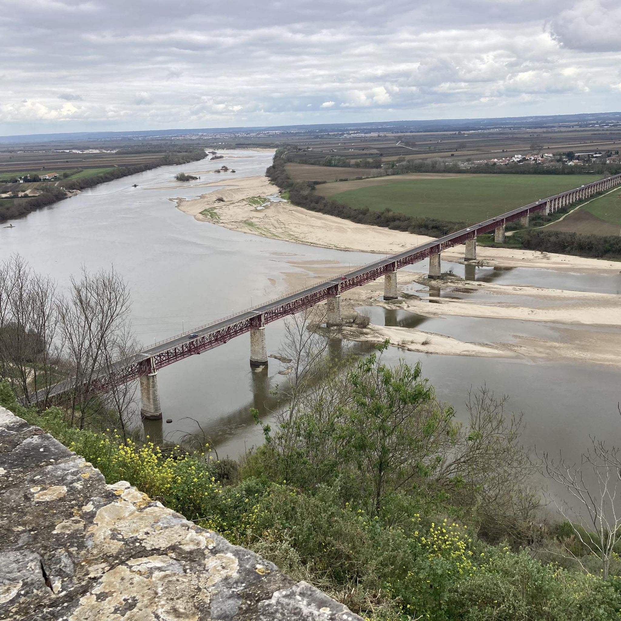
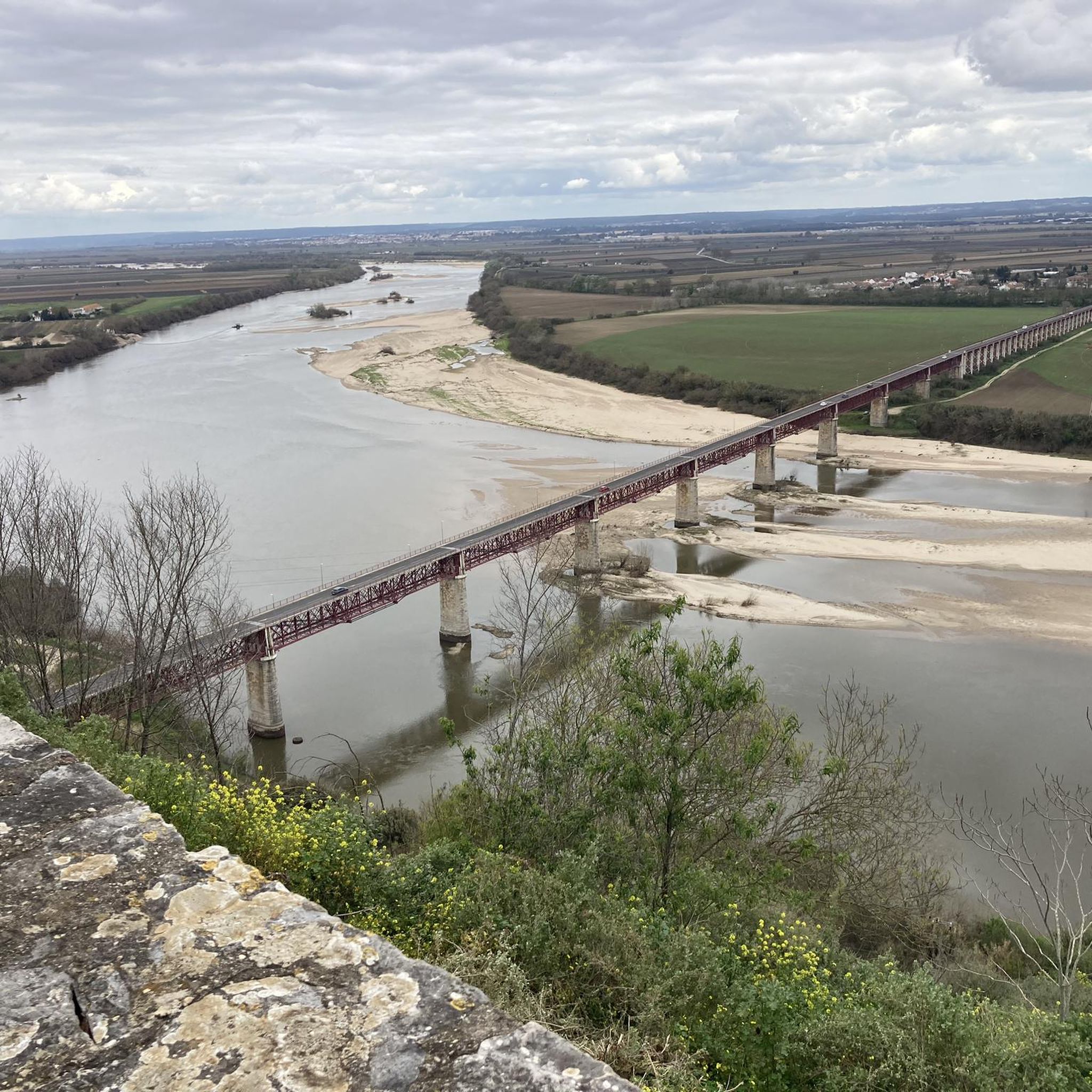
The region offers a blend of natural beauty and historical sites. You can encounter historic structures like the Ponte Rainha D. Amélia and the Roman Bridge of Muge, which provide superb views and a glimpse into the region's past. The city of Santarém itself, known as the 'Gothic Capital,' boasts landmarks like the Jardim das Portas do Sol, which offers sweeping views of the Tagus River and its plains.
Are there any circular hiking routes available?
Yes, several circular routes are popular in the area. A highly-rated option is the From Planalto de Santarém to Rio Tejo (PR 2) — circular route, an easy 4.3-mile trail. Another local favorite is the Jardim das Portas do Sol – Igreja de São João de Alporão loop from Santarém, a 4.2-mile path that takes you through urban and natural landscapes.
What do other hikers say about the trails around Vale de Santarém?
The routes around Vale de Santarém are highly rated by the komoot community, with an average score of 4.9 stars from over 10 reviews. Hikers often praise the accessible nature of the trails, the serene beauty of the Tagus River valley, and the blend of natural and historic sights. Over 70 hikers have used komoot to explore this varied terrain.
Is the area suitable for family-friendly walks?
Absolutely. The generally flat to gently undulating terrain of the Tagus River valley makes many of the routes around Vale de Santarém ideal for families. These easy walks through fields, olive groves, and along riverbanks provide a pleasant and accessible outdoor experience for all ages.
Are there options for dog-friendly hiking in Vale de Santarém?
Many of the rural paths and agricultural trails in the Vale de Santarém area are suitable for dog walking. The open fields and riverbanks provide ample space for dogs to enjoy the outdoors. Always ensure your dog is under control and respect local regulations regarding pets in natural areas.
What is the best time of year to go hiking in Vale de Santarém?
The region is pleasant for hiking for much of the year. Spring and autumn offer mild temperatures, making them ideal for exploring the agricultural plains and river systems. Summers can be warm, so early morning or late afternoon hikes are recommended during this season. Winters are generally mild, allowing for comfortable walks, though some paths might be muddier after rain.
How can I get to the hiking trails using public transport?
While specific public transport routes directly to every trailhead might vary, the city of Santarém serves as a central hub. From Santarém, you can often access various starting points for trails, including those that offer views of the Tagus River and its plains. It's advisable to check local bus schedules or taxi services from Santarém to reach more remote trailheads.
Are there any cafes or restaurants near the hiking routes in Vale de Santarém?
Vale de Santarém and the broader Santarém municipality offer an authentic rural experience, including local eateries. You'll find cafes and restaurants in the villages and towns, particularly in Santarém city, where you can enjoy local cuisine and refreshments before or after your hike. These establishments are often integrated into the historic urban areas or rural settings.
What kind of natural features define the landscape for hiking in this region?
The landscape is primarily defined by the fertile Tagus River Valley (Lezíria), featuring vast agricultural plains, vineyards, and olive groves. Beyond the Tagus, the district is rich in other river systems and wetlands, which are vital for birdwatching and offer distinct walking environments. The proximity to the Serras de Aire e Candeeiros Natural Park also means that unique geological formations and limestone massifs are within reach for more diverse hiking experiences.
Are there any longer or more challenging routes for experienced hikers?
While most routes directly around Vale de Santarém are easy, the wider Santarém region does offer some moderate options. For example, the Sá da Bandeira Square – Igreja de São João de Alporão loop from Santarém is a moderate 5.3-mile trail. For more challenging terrain, the nearby Serras de Aire e Candeeiros Natural Park, about 20 minutes from Santarém, provides diverse trails through limestone massifs with more significant elevation changes.
Most popular attractions around Vale De Santarém

Get inspired with the komoot mobile app


Explore more
Browse the best Hikes in other regions.
