The best walks and hikes around Chacra
4.0
(2)
38
hikers
4
hikes
Hiking around Chacra, Colorado, offers a variety of trails through diverse landscapes. The region features a mix of river valleys, forested areas, and open terrain, with elevation changes that range from gentle to challenging. Trails often traverse areas with varied flora and provide views of the surrounding natural environment. The area is characterized by its network of paths suitable for different hiking preferences.
Best hiking trails around Chacra
- The most popular hiking route is Rio Grande Trail, a 4.3…
Last updated: September 27, 2026
4.0
(2)
16
hikers
5.10km
01:50
290m
290m
Easy hike. Great for any fitness level. Easily-accessible paths. Suitable for all skill levels.
9
hikers
6.95km
01:48
40m
40m
Easy hike. Great for any fitness level. Easily-accessible paths. Suitable for all skill levels.

4
hikers
4.14km
01:10
90m
90m
Easy hike. Great for any fitness level. Easily-accessible paths. Suitable for all skill levels.
3
hikers
4.94km
01:56
220m
220m
Hard hike. Great for any fitness level. Sure-footedness, sturdy shoes and alpine experience required.
1
hikers
2.48km
00:44
70m
70m
Easy hike. Great for any fitness level. Easily-accessible paths. Suitable for all skill levels.
Our route recommendations are based on thousands of hikes, rides, and runs completed by other people on komoot.
Start today with a free account
Your next adventure awaits.
Popular around Chacra

Tips from the Community

Nice to walk along the river, but nothing special.
1
0

From this pedestrian bridge, you can enjoy a view above the Roaring Fork River. Here is the connection between the Rio Grande Trail and the Atkinson Canal Trail. This is an easy walk/bike trail that runs alongside the river. Rio Grande Trail connects Glenwood Springs to Aspen, so you can choose your distance and go for as long as you like.
0
0
From this pedestrian bridge, you can enjoy a view above the Roaring Fork River. Here is the connection between the Rio Grande Trail and the Atkinson Canal Trail. This is an easy walk/bike trail that runs alongside the river. Rio Grande Trail connects Glenwood Springs to Aspen, so you can choose your distance and walk for as long as you like.
0
0

This is a great place to park to access the bike path along the Colorado River through Glenwood Canyon. There are restrooms, river access, and shaded green space at the park.
1
0
The trail is nontechnical, wide, and made of crushed stone. It winds through the red dirt and partial stone of the preserve with some nice sloping descents.
0
0

The Colorow Trail just north of New Castle is a great loop to enjoy some solitude in the Colorado mountains. It is steep in places, but offers stunning views over the Colorado River Valley. You might encounter mountain bikers along your run. If you don't want to hike the whole loop, you can take the Stairway to Heaven for a shorter option.
0
0

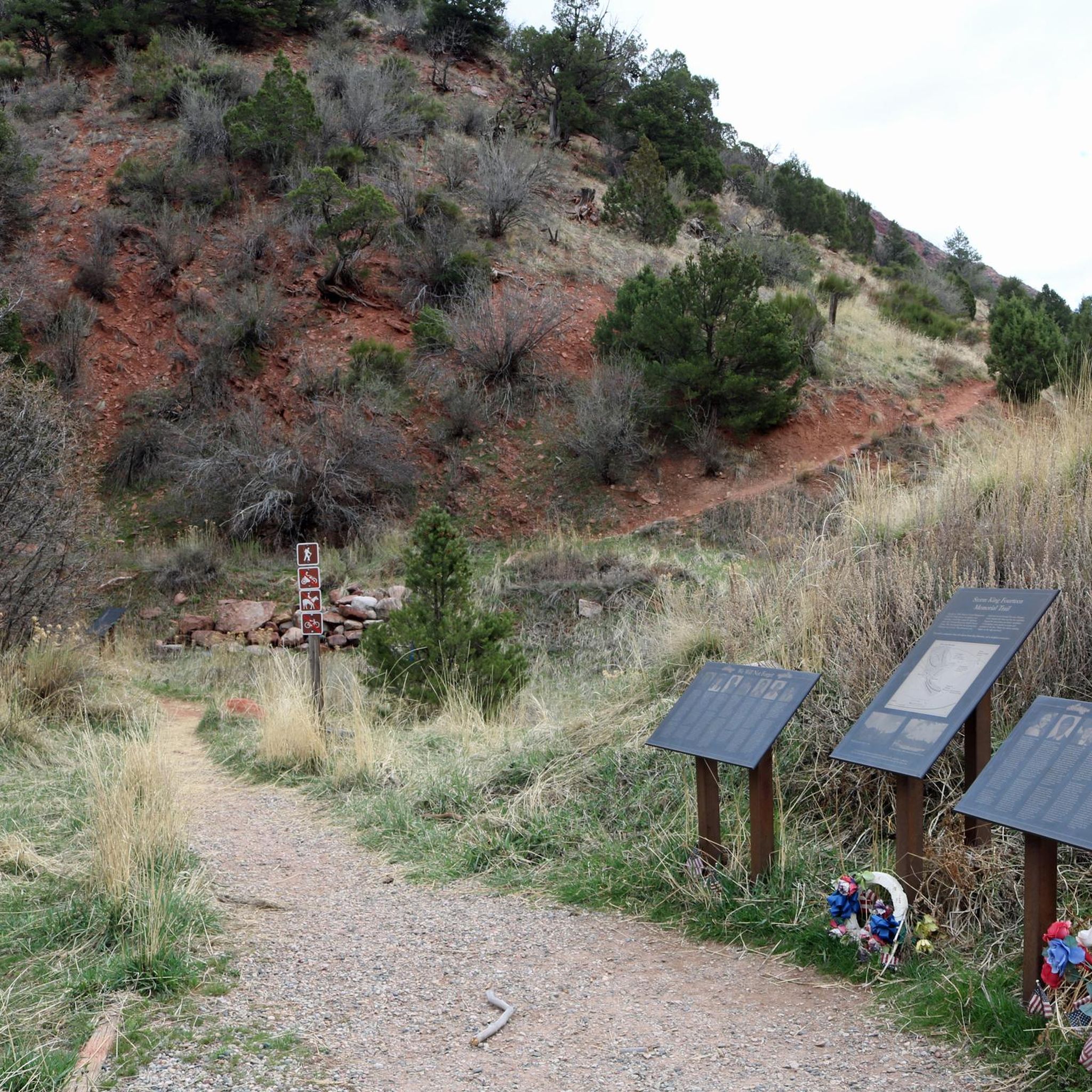
From the top of the Memorial Trail you'll enjoy a magnificent view of Storm King Mountain to the North East, towering above the narrow valley.
0
0
Medaris Ridge is a great place to take a stroll to: not too much of a climb, but you still have a nice view over the Colorado River and the rollings hills surrounding New Castle.
3
0
Frequently Asked Questions
What types of hiking trails can I expect around Chacra?
Chacra, Colorado, offers a diverse range of hiking experiences. You'll find trails through river valleys, forested sections, and open terrain. The routes vary in elevation change, from gentle, flat paths to more challenging ascents, catering to different skill levels.
Are there any easy, family-friendly hiking options in Chacra?
Yes, Chacra has several easy trails suitable for families. The Rio Grande Trail is an excellent choice, offering a flat path along the river. Another moderate, family-friendly option mentioned in the region research is the Red Hill Loop, which covers nearly 6 miles.
Which trails are suitable for hikers looking for a challenge?
For experienced hikers seeking a challenge, the Colorow Trail West and East Loop is a difficult option with significant elevation changes. Regionally, Mount Sopris is a strenuous 13-mile trail with over 4,600 feet of elevation gain, offering a demanding experience.
Can I bring my dog on the hiking trails in Chacra?
Yes, some trails in the Chacra area are dog-friendly. The Rio Grande Trail, for example, is noted as allowing dogs, making it a great option for hiking with your canine companion.
What are some interesting landmarks or points of interest to see while hiking in Chacra?
While hiking in Chacra, you can explore several points of interest. The Storm King Mountain Memorial Trail itself is a significant site, and nearby you'll find the Storm King Firefighters Memorial. Additionally, Two Rivers Park offers a pleasant stop.
Are there any circular hiking routes available in Chacra?
Yes, there are circular routes. The Wulfsohn Trail Loop is an easy circular hike, and the Colorow Trail West and East Loop also offers a loop experience, though it is rated as difficult.
What do other hikers say about the trails in Chacra?
The trails in Chacra are highly regarded by the komoot community, with an average rating of 4.0 stars. Hikers often appreciate the varied terrain and the options available for different ability levels, from easy river paths to more challenging ascents.
Are there any trails that offer opportunities for fishing?
Based on regional information, the Wall Lake Trail, a strenuous 8-mile option, provides opportunities for fishing along its course. This trail is located within the broader Chacra region.
How long do typical hikes in Chacra take?
Hiking durations in Chacra vary depending on the trail's length and difficulty. For example, the Rio Grande Trail, at 4.3 miles, typically takes about 1 hour 48 minutes, while the Colorow Trail West and East Loop, at 3.1 miles but with more elevation, can take around 1 hour 55 minutes.
Are there any trails suitable for backpacking in the Chacra area?
Yes, for those interested in backpacking, the Thomas Lakes Out and Back trail is a moderate 8-mile route with over 1,600 feet of elevation gain that is popular for backpacking within the Chacra region.
Where can I find trailheads and parking for hikes around Chacra?
Specific trailheads and parking information can often be found on individual route pages. For instance, the Red Hill Trailhead is a known starting point for trails in the area. It's always recommended to check the details for your chosen route on komoot for precise access information.
What are some less-trafficked or 'hidden gem' trails in the Chacra region?
While specific 'hidden gems' can be subjective, exploring trails like the Medaris Ridge and Ditch Trail, which is a shorter, easy option, might offer a quieter experience compared to more popular routes. The region's network of paths often provides alternatives to well-known trails.
Most popular routes around Chacra
Most popular attractions around Chacra

Get inspired with the komoot mobile app


Explore more
Browse the best Hikes in other regions.
