The best road cycling routes around Bonnevent-Velloreille
4.6
(20)
635
riders
50
rides
Road cycling routes around Bonnevent-Velloreille traverse the diverse landscapes of the Haute-Saône department in France. The region features a mix of valleys, forests, and plateaus, offering varied terrain for cyclists. Routes primarily utilize paved surfaces, catering to different fitness levels with options ranging from gentle stretches to more undulating sections. This topographical diversity provides engaging backdrops for road cycling.
Best road cycling routes around Bonnevent-Velloreille
- The most popular road cycling route is View of Recologne – Recologne Castle loop from…
Last updated: July 2, 2026
5.0
(2)
35
riders
Moderate road ride. Good fitness required. Mostly well-paved surfaces and easy to ride.
5.0
(1)
27
riders
32.0km
01:24
270m
270m
Easy road ride. Great for any fitness level. Mostly well-paved surfaces and easy to ride.

Sign up for free
11
riders
46.1km
02:02
450m
450m
Moderate road ride. Good fitness required. Mostly well-paved surfaces and easy to ride.
7
riders
Moderate road ride. Good fitness required. Mostly well-paved surfaces and easy to ride.
6
riders
42.3km
01:51
380m
380m
Moderate road ride. Good fitness required. Mostly well-paved surfaces and easy to ride.
Get access to more routes and recommendations from other explorers.
Sign up for free
Already have an account?
Our route recommendations are based on thousands of hikes, rides, and runs completed by other people on komoot.
Start today with a free account
Your next adventure awaits.
Login or Signup



Tips from the Community

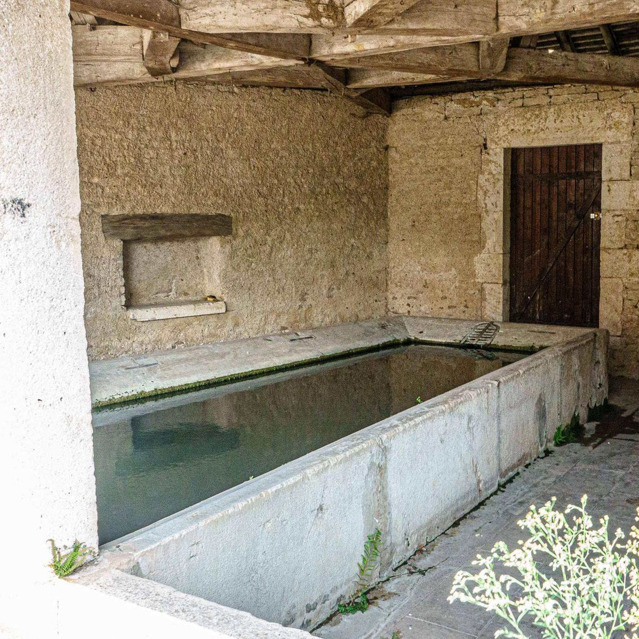
The grand lavoir-abreuvoir in Geneuille is a historical monument dating from the 19th century. It was built in 1829 and restored in 1876 by the architect Ducat. This lavoir-abreuvoir, located on the rue de l’Abreuvoir, is a covered washhouse with a large abreuvoir running along the facade. It has a large esplanade for easy access. The complex consists of a fountain, a washhouse and a abreuvoir, and is an important vestige of the social life and work of our ancestors. The water enters via a canal and is collected in a large space with a beautiful vaulted structure.
8
0
A double, neo-antique temple and wash house (1845), with very beautiful Ionic columns, containing a water reservoir.
10
4
Fountain by the architect Pierre Marnotte, built in 1845-1846 and representing two small forts. This monument (listed as a historic monument) is lit up at dusk.
11
4
Etuz is a commune in the Haute-Saône department. Etuz is located on the Ognon River, which forms the border with the Doubs department. Etuz is part of the urban unit of Cussey-sur-l’Ognon and the attraction of Besançon. Etuz has a fountain and two wash houses dating from the 19th century. It also has a church dedicated to Saint-Martin, which was built in the 18th century on the site of an older church. Etuz is a rural commune, where agriculture and forestry are mainly practiced.
10
4
Parish church of the Nativity of Our Lady, rebuilt in 1726 and with a flat-roofed bell tower from 1834 with four faces, listed as a historic monument19, with two altarpieces and an altar, also listed. Washhouse fountain20 (with the roof renovated in recent years)[When?]. Renaissance-style house with a turret. Old rural fabric.
10
4

Water hole in a deep oak forest.
0
0

The Aurêtre pond is located north of Besançon in the commune of Geneuille. It presents a pretty bucolic setting when nature is in bloom.
0
0

Bellevaux Abbey was a Cistercian monastery, founded in 1120 by Pons de Morimond, near present-day Cirey, in Haute-Saône, France. At that time it was in Franche-Comté. It was removed in 1790 and sold in 1791. Shortly after, the church was demolished. 1795 the buildings were purchased by Jean-Charles Pichegru. The “castle” site, for its part, hosts events (medieval festivals, markets) in its park thanks to the dynamism of an association seeking to promote the former religious domain. The old abbey is open to visitors from time to time. Information on 06 33 80 08 12 or 03 84 94 84 98.
0
0
Frequently Asked Questions
How many road cycling routes are available around Bonnevent-Velloreille?
There are over 50 road cycling routes around Bonnevent-Velloreille, offering a wide variety of options for cyclists. These routes are primarily on paved surfaces, traversing the diverse landscapes of the Haute-Saône department.
What kind of terrain can I expect on road cycling routes in Bonnevent-Velloreille?
The region around Bonnevent-Velloreille features a mix of valleys, forests, and plateaus. You can expect routes with mostly paved surfaces, ranging from gentle stretches to more undulating sections, providing engaging backdrops for your ride.
Are there road cycling routes suitable for different fitness levels?
Yes, Bonnevent-Velloreille offers routes catering to varying fitness levels. You'll find options from easier rides with minimal elevation gain to more challenging excursions involving significant elevation changes. Out of 54 routes, 13 are considered easy, 37 moderate, and 4 difficult.
What are some notable landmarks or historical sites I can see along the cycling routes?
The area boasts several historical attractions that can enhance your cycling experience. You might encounter the grand lavoir-abreuvoir in Geneuille, a 19th-century historical monument. Other points of interest include a neo-antique temple and wash house in Etuz, and the fortified manor of Sorans-lès-Breurey, a 16th-century structure.
Are there any circular road cycling routes in the area?
Yes, many of the road cycling routes around Bonnevent-Velloreille are designed as loops, allowing you to start and end your ride in the same location. An example is the moderate Chapelle Saint-Justin – Venice, a city on the water? loop from Étuz, which covers 31.8 miles (51.2 km).
What do other road cyclists enjoy most about cycling in Bonnevent-Velloreille?
The road cycling routes around Bonnevent-Velloreille are highly rated by the komoot community, with an average score of 4.5 stars from over 20 reviews. Cyclists often praise the varied terrain, the mix of open stretches and forested areas, and the well-maintained paved surfaces that make for an enjoyable ride.
Can you recommend a moderate road cycling route that offers good views?
For a moderate ride with scenic views, consider the View of Recologne – Recologne Castle loop from Montboillon. This 29.4-mile (47.2 km) route offers views of the local countryside and passes by historical points of interest, typically taking about 2 hours and 5 minutes to complete.
Are there any longer, more challenging road cycling routes available?
Yes, for those seeking a longer and more challenging ride, the Corneux Abbey – Maison de Maître Mugnier loop from Villers-Chemin is a great option. This moderate route spans 37.4 miles (60.1 km) with significant elevation changes, offering a more demanding experience.
What is a good road cycling route for exploring local valleys and plateaus?
The Venice, a city on the water? loop from Boult is an excellent choice for exploring the local valleys and plateaus. This 28.6-mile (46.1 km) route provides a good representation of the region's diverse topography.
Are there routes that feature significant climbs or elevation gain?
Absolutely. Routes like the Gy Mountains – The climb of le Cordonnet loop from Cordonnet offer substantial elevation gain, with over 590 meters (1935 feet) of ascent. This route is ideal for cyclists looking for a more strenuous workout and panoramic views.
Is public transport or parking available near the road cycling routes?
While specific public transport links directly to trailheads are limited in this rural area, parking is generally available in the villages and towns where many routes begin, such as Montboillon, Étuz, or Boult. It's advisable to check local parking options for your chosen starting point.
Most popular routes around Bonnevent-Velloreille
Most popular attractions around Bonnevent-Velloreille

Get inspired with the komoot mobile app


Explore more
Browse the best Road cycling routes in other regions.
