The best traffic-free bike rides in Jefferson County
4.9
(39)
343
riders
17
rides
No traffic gravel bike trails in Jefferson County traverse a diverse landscape, from the eastern shortgrass prairies to the western subalpine forests of the Rocky Mountain foothills. The region features extensive open space parks with crushed gravel, packed dirt, and singletrack trails, often following canals, rivers, and reservoir shorelines. This varied terrain provides options for different skill levels, incorporating both flat paths and routes with significant elevation gain.
Best no traffic gravel bike trails in Jefferson County
- The most popular…
Last updated: May 27, 2026
5.0
(2)
50
riders
Hard gravel ride. Very good fitness required. Mostly paved surfaces. Suitable for all skill levels.
5.0
(3)
45
riders
142km
10:25
650m
650m
Hard gravel ride. Very good fitness required. Mostly paved surfaces. Suitable for all skill levels.

Sign up for free
5.0
(1)
17
riders
95.9km
07:49
290m
290m
Hard gravel ride. Very good fitness required. Mostly paved surfaces. Suitable for all skill levels.
5.0
(2)
34
riders
56.6km
04:25
130m
130m
Moderate gravel ride. Good fitness required. Mostly paved surfaces. Suitable for all skill levels.
4.8
(8)
17
riders
26.8km
01:50
50m
50m
Easy gravel ride. Great for any fitness level. Mostly paved surfaces. Suitable for all skill levels.
Get access to more routes and recommendations from other explorers.
Sign up for free
Already have an account?
Our route recommendations are based on thousands of hikes, rides, and runs completed by other people on komoot.
Start today with a free account
Your next adventure awaits.
Login or Signup




Tips from the Community

One of my favorite rides! The trail is well maintained and smooth. So many spots to rest and take breathtaking pics
1
0

28 Sept 2025: staircase closed as they rebuild it
0
0

A paved elevated boardwalk stretches out along the water, giving you a fantastic view of the Potomac River. This spot can get pretty popular on summer weekends.
0
0

Dam No. 4 is located around mile 84 of the C&O Canal Towpath. Built in 1856, this dam was crucial for maintaining water levels for canal operations and remains an impressive structure along the river. The area around the dam is known for its scenic views and wildlife.
0
0
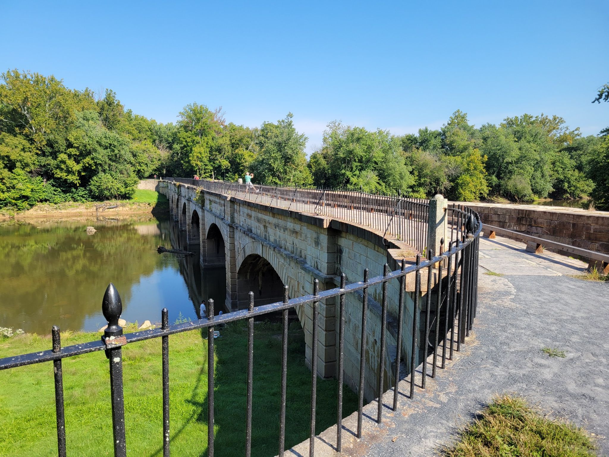
The Antietam Aqueduct was built in 1834 to carry canal boats over Antietam Creek. It is over 140 feet long and is one of many such aqueducts along the C&O Canal.
0
0
The Antietam Aqueduct, located at mile 69.4 of the C&O Canal Towpath, is a three-arch stone aqueduct that once carried the canal over Antietam Creek. Built in 1834, it is constructed from limestone quarried nearby and remains one of the best-preserved aqueducts along the canal. During the Civil War, it was near the site of Confederate troop movements before and after the Battle of Antietam in 1862. Though it suffered some damage over the years, it has been fully restored and now serves as a scenic and historic stop along the towpath, offering great river views and picnic spots.
0
0
Dam No. 4 is located around mile 84 of the C&O Canal Towpath. Built in 1856, this dam was crucial for maintaining water levels for canal operations and remains an impressive structure along the river. The area around the dam is known for its scenic views and wildlife, making it a nice spot to pause before continuing on your ride.
0
0
Dam No. 5 is located along the C&O Canal Towpath near mile 106, between Williamsport and Hancock, Maryland. Constructed between 1833 and 1835, it was built to raise water levels in the Potomac River and ensure a steady supply for the canal's operation. Like the other dams along the canal, Dam No. 5 was crucial for maintaining navigable water levels for canal boats, allowing them to bypass the river’s natural rapids and shallow areas. During the Civil War, Dam No. 5 became a strategic target for Confederate forces, who attempted to destroy it multiple times in an effort to disrupt Union transportation and supply lines. In December 1861, Confederate General Stonewall Jackson led an attack on the dam, but despite several attempts, Union troops successfully defended it, keeping the canal operational. Today, Dam No. 5 remains a picturesque and historically significant site along the towpath. The area is known for its scenic views of the Potomac, with rushing water cascading over the dam and wildlife such as bald eagles, herons, and fish frequently spotted.
1
0
Frequently Asked Questions
How many no-traffic gravel bike trails are available in Jefferson County, Colorado?
This guide features 16 carefully selected routes for traffic-free gravel biking in Jefferson County. These trails offer a diverse range of experiences, from easy spins to more challenging rides, all designed to keep you away from motorized traffic.
What kind of terrain can I expect on Jefferson County's no-traffic gravel trails?
Jefferson County offers a rich variety of terrain, blending the Great Plains with the Rocky Mountain foothills. You'll find everything from crushed gravel and packed dirt paths in open space parks to wider singletrack sections. Routes often incorporate diverse surfaces, ensuring a varied and engaging ride.
Are there any family-friendly no-traffic gravel bike trails in Jefferson County?
Yes, many of Jefferson County's open space parks provide excellent family-friendly options. Trails like those found in South Valley Park or along the Fairmont Canal Trail offer easier, flatter sections perfect for riders of all ages. These areas are known for their gentle gradients and scenic, car-free environments.
Can I bring my dog on these gravel bike routes?
Many open space parks in Jefferson County are dog-friendly, but leash laws are strictly enforced. It's always best to check the specific regulations for each park or trail you plan to visit to ensure a pleasant and safe experience for everyone.
What are some scenic viewpoints or natural features I can expect to see?
Jefferson County's trails offer spectacular views. You can expect panoramic vistas of the Front Range, including Pikes Peak, from areas like Daniels Park. Waterton Canyon is famous for bighorn sheep sightings, while other trails wind along reservoir shorelines and through diverse landscapes, from prairies to subalpine forests.
Are there any loop options for no-traffic gravel biking in Jefferson County?
Yes, many of the trails within Jefferson County's extensive open space network can be combined to form satisfying loops. For instance, trails within South Valley Park can be ridden as a loop or connected to nearby areas like Deer Creek Canyon for longer circular routes.
What is the best time of year to gravel bike in Jefferson County?
Spring and fall generally offer the most pleasant conditions for gravel biking in Jefferson County, with mild temperatures and beautiful scenery. Summer can be warm, so early morning rides are recommended. Winter riding is possible, but be prepared for colder temperatures and potential snow or ice, especially at higher elevations.
Where can I park when accessing these no-traffic gravel trails?
Most major open space parks and trailheads in Jefferson County provide dedicated parking facilities. Popular spots like Waterton Canyon, Chatfield State Park, and various access points for the Highline Canal Trail typically have ample parking available. Always check specific park information for details.
Are there any cafes or pubs near the gravel bike trails in Jefferson County?
While many trails offer a sense of remoteness, you'll find towns and communities with cafes, pubs, and restaurants within a reasonable distance of various trailheads. Areas surrounding parks like Green Mountain or South Table Mountain often have convenient options for post-ride refreshments.
What makes Jefferson County a great destination for no-traffic gravel biking?
Jefferson County stands out due to its vast network of open space parks and trails that prioritize non-motorized use. The convergence of the Great Plains and Rocky Mountain foothills creates incredibly diverse and scenic routes, ensuring a peaceful and engaging gravel biking experience away from cars. The komoot community rates the gravel routes highly, with an average score of 4.88 stars.
What is the typical elevation gain on these no-traffic gravel routes?
The elevation gain varies significantly across Jefferson County's no-traffic gravel trails. You can find relatively flat paths, particularly in eastern sections or along canal trails, perfect for an easier ride. However, routes venturing into the foothills or areas like Daniels Park can offer challenging climbs with substantial elevation gain, catering to riders seeking a workout.
Most popular routes in Jefferson County
Most popular attractions in Jefferson County

Get inspired with the komoot mobile app


Explore more
Browse the best Gravel rides in other regions.
