The best traffic-free bike rides in Clark County
5.0
(16)
362
riders
11
rides
No traffic road cycling routes in Clark County traverse a diverse landscape, offering experiences from desert scenery and red rock formations to serene wetlands and cooler mountain elevations. The region features varied terrain, including striking sandstone peaks and expansive valleys. Cyclists can find routes that navigate through unique geological formations and along scenic byways. This varied topography provides a range of challenges and scenic backdrops for road cycling.
Best no traffic road cycling routes in Clark County
- The most popular…
Last updated: May 27, 2026
5.0
(3)
39
riders
51.1km
02:29
170m
170m
Moderate road ride. Good fitness required. Mostly well-paved surfaces and easy to ride.
5.0
(1)
35
riders
52.3km
02:29
160m
160m
Moderate road ride. Good fitness required. Mostly well-paved surfaces and easy to ride.

Sign up for free
18
riders
38.6km
02:16
140m
140m
Moderate road ride. Good fitness required. Some segments of this route may be unpaved and difficult to ride.
17
riders
69.9km
02:54
270m
270m
Moderate road ride. Good fitness required. Mostly well-paved surfaces and easy to ride.
9
riders
22.5km
01:15
80m
80m
Easy road ride. Great for any fitness level. Mostly well-paved surfaces and easy to ride.
Get access to more routes and recommendations from other explorers.
Sign up for free
Already have an account?
Our route recommendations are based on thousands of hikes, rides, and runs completed by other people on komoot.
Start today with a free account
Your next adventure awaits.
Login or Signup


Other adventures in Clark County

Tips from the Community

The Creekside Trail is a great 16-mile long trail that connects Dayton and Xenia. The trail is fully paved and is popular with walkers and cyclists. This section runs through several parks and green spaces, so it is a wonderful segment to ride.
0
0

Southern Ohio Brewery is right off the Beavercreek Trail Connector and is a great spot to grab some refreshments and food as a break along your ride.
0
0

This 700-acre preserve was created from a gift of land to Antioch College by Hugh Taylor Birch to honor his daughter, Helen Birch Bartlett. Much of it is along the two creeks that flow by, and the trails access a number of picturesque waterfalls.
0
0
The Prairie Grass Trail is a 29-mile trail from Xenia to London and is part of the Ohio to Erie Trail. The trail is fully paved and mostly flat. This section takes you through open fields and into Cedarville, where there are options to refuel.
1
0
Cedarville is a beautiful small town in Greene County. The town was originally settled by Irish and Scottish immigrants in 1799. It is right off the Prairie Grass Trail and is a great place for a break. The town is home to Cedarville University, which has a nice campus and lake that are open public visits.
1
0
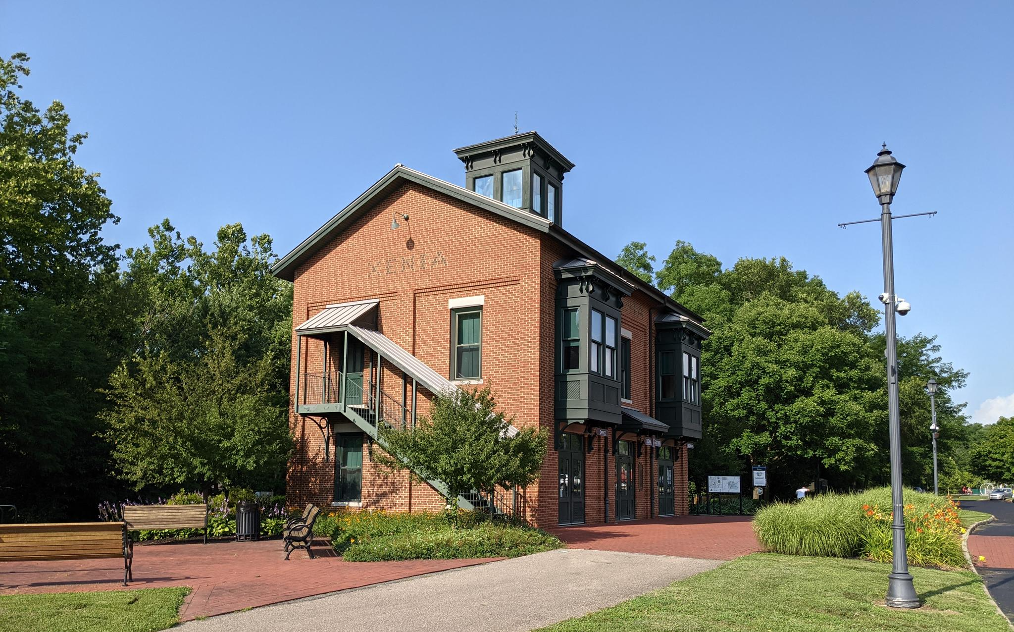
The Xenia Station is a replica of an old brick train station that used to be in the area. It now holds a museum and meeting space, and serves as a trail head for several trails that intersect at this point.
1
0
The Creekside Trail is a great 16-mile long trail that connects Dayton and Xenia. The trail is fully paved and is popular with walkers and cyclists. This section runs through several parks and green spaces, so it is a wonderful segment to walk.
0
0
Cedarville is a beautiful small town in Greene County. The town was originally settled by Irish and Scottish immigrants in 1799. It is right off the Prairie Grass Trail and is a great place for a break. The town is home to Cedarville University, which has a nice campus and lake that are open to public visits.
1
0
Frequently Asked Questions
How many no-traffic road cycling routes are available in Clark County?
Clark County offers a diverse selection of road cycling routes designed to minimize traffic, with over a dozen options available. These routes cater to various skill levels, from easy to moderate, ensuring a suitable ride for most cyclists.
What are the difficulty levels of the no-traffic road cycling routes?
The no-traffic road cycling routes in Clark County range from easy to moderate. You'll find 3 easy routes perfect for a relaxed ride, and 9 moderate routes that offer a bit more challenge with varied terrain and elevation changes.
What kind of terrain can I expect on no-traffic road cycling routes in Clark County?
Clark County's no-traffic road cycling routes offer incredibly diverse terrain. You can expect everything from the striking red rock formations and desert landscapes of areas like Red Rock Canyon and Valley of Fire, to the serene wetlands of Clark County Wetlands Park, and even cooler, forested mountain elevations around Mount Charleston. Many routes feature paved surfaces with scenic views.
Are there any circular no-traffic road cycling routes in Clark County?
Yes, Clark County features several excellent circular routes. A notable example is the River Mountains Loop Trail within the Lake Mead National Recreation Area, which is a challenging 37.6-mile paved route offering stunning vistas of the desert and Lake Mead. The 13-mile scenic drive in Red Rock Canyon is also a classic loop for cyclists.
What are some scenic landmarks or points of interest along these routes?
You'll encounter breathtaking scenery and unique landmarks. In Red Rock Canyon, you'll see dramatic sandstone peaks and walls. Valley of Fire State Park is famous for its fiery red Aztec sandstone formations like the Seven Sisters and Fire Wave. Lake Mead offers expansive lake views, while Clark County Wetlands Park provides a lush oasis with diverse ecosystems and opportunities for wildlife viewing.
What is the best time of year to enjoy no-traffic road cycling in Clark County?
The best time to cycle in Clark County is typically during the cooler months, from fall through spring (October to April), when temperatures are more moderate. Summer can be extremely hot, especially in desert areas. Mount Charleston offers a cooler escape during warmer months, making it an option for summer cycling.
Are there family-friendly no-traffic road cycling options?
Yes, there are family-friendly options, particularly on easier, paved sections. The Clark County Wetlands Park features a 14-mile Wetlands Loop Trail, with approximately 9.5 miles of paved surface, offering a relatively flat and safe environment suitable for families. Some sections of the Historic Railroad Trail within Lake Mead National Recreation Area are also suitable for a more relaxed family ride.
What do other road cyclists enjoy most about cycling in Clark County?
The komoot community highly rates the cycling experience in Clark County, with an average score of 4.8 stars. Reviewers often praise the stunning and unique desert landscapes, the well-maintained paved routes that offer minimal traffic, and the diverse challenges ranging from gentle loops to significant mountain climbs. The opportunity to cycle through iconic areas like Red Rock Canyon and Valley of Fire is frequently highlighted.
Where can I find parking for no-traffic road cycling routes?
Parking is generally available at the entrances or designated trailheads for major cycling areas. For instance, Red Rock Canyon National Conservation Area has parking along its scenic drive, and Lake Mead National Recreation Area and Valley of Fire State Park also provide parking facilities at various access points. It's always advisable to check specific park websites for detailed parking information before your visit.
Can I access these routes using public transport?
While some areas around Las Vegas have public transport, direct access to many of the more remote no-traffic road cycling routes in places like Red Rock Canyon, Valley of Fire, or Lake Mead by public transport can be limited. It's often more convenient to use a personal vehicle or ride-sharing services to reach the trailheads, especially for routes further outside the immediate urban areas.
Are there any challenging no-traffic road cycling routes for experienced riders?
Absolutely. Experienced riders seeking a challenge will find routes like the Kyle Canyon road (Hwy 157) on Mount Charleston particularly demanding, with significant climbs and substantial elevation gains over 20 to 25 miles. The Valley of Fire Scenic Byway also presents numerous climbs and descents, offering a rigorous and rewarding experience amidst spectacular scenery.
What kind of wildlife might I encounter on these routes?
Clark County's diverse ecosystems support a variety of wildlife. In desert areas, you might spot desert tortoises, bighorn sheep, various lizards, and raptors. Wetlands Park is a haven for numerous bird species, while Lake Mead also hosts a range of birds and aquatic life. Always observe wildlife from a distance and do not disturb their natural habitats.
Most popular routes in Clark County

Get inspired with the komoot mobile app


Didn’t find what you were looking for?
Check out more Road cycling routes throughout Clark County below and find the perfect route in your destination.
Explore more
Browse the best Road cycling routes in other regions.
