The best traffic-free bike rides around Melito Di Porto Salvo
4.0
(2)
264
riders
3
rides
No traffic road cycling routes around Melito Di Porto Salvo traverse a diverse landscape at the southernmost tip of Italy's Calabria region. The area features a dramatic Ionian coastline with fine sand beaches, transitioning quickly into the rugged terrain of the Aspromonte mountains and National Park. Cyclists encounter varied elevations, from coastal roads to ascents towards peaks like Mount Calvario, offering a blend of sea views and mountain challenges. The region prioritizes low-traffic roads, providing dedicated routes for cycling enthusiasts.
Best no traffic road cycling routes around Melito Di Porto Salvo
- The most popular no traffic road cycling route is Pentedattilo Village loop from Melito di Porto Salvo, an easy 9.9 miles (15.9 km) trail that takes about 1 hour to complete. This route offers a scenic ride to the unique Pentedattilo Village, known for its distinctive rock formations.
- Another top favourite among local road cyclists is Gallicianò Village – Passo della Zita loop from Condofuri, a difficult 43.4 miles (69.8 km) path. This challenging route features significant elevation gain through the mountainous terrain of the Aspromonte region.
- Local road cyclists also love the Faro di Capo dell'Armi loop from Motta San Giovanni - Lazzaro, an 18.1 miles (29.2 km) trail leading through coastal landscapes, often completed in about 2 hours. This route provides panoramic views of the Ionian Sea.
- Road cycling around Melito Di Porto Salvo is defined by coastal paths, mountain ascents in the Aspromonte National Park, and routes to historic villages like Pentedattilo. The network offers options for different ability levels, from easy coastal rides to challenging mountain loops.
- The guide includes highly-rated routes that showcase the best of the region's landscape. More than 150 road cyclists have used komoot to explore Melito Di Porto Salvo's varied terrain.
Last updated: July 14, 2026
8
riders
15.8km
00:57
270m
270m
Easy road ride. Great for any fitness level. Mostly well-paved surfaces and easy to ride.
3
riders
69.9km
04:41
2,240m
2,240m
Hard road ride. Very good fitness required. Mostly well-paved surfaces and easy to ride.

Sign up for free
2
riders
29.3km
02:01
920m
920m
Hard road ride. Very good fitness required. Mostly well-paved surfaces and easy to ride.
1
riders
35.4km
02:08
890m
890m
Moderate road ride. Good fitness required. Mostly well-paved surfaces and easy to ride.
Our route recommendations are based on thousands of hikes, rides, and runs completed by other people on komoot.
Start today with a free account
Your next adventure awaits.
Login or Signup
Popular around Melito Di Porto Salvo
Other adventures around Melito Di Porto Salvo

Tips from the Community

Leucopetra (from the Greek "white stone") is primarily an ancient and significant Greco-Roman toponym, referring to a rocky promontory in Calabria, near Reggio Calabria, known for its Capo d'Armi lighthouse and for having been a historical and geographical landmark, but the term may also refer to a locality near Corinth (Greece) and, by mythological extension, to the sea goddess Leucothea.
0
0

Suitable equipment is needed: boots, poles and accessories, but the important thing is to have an adequate supply of water because there are no fountains along the route.
1
0

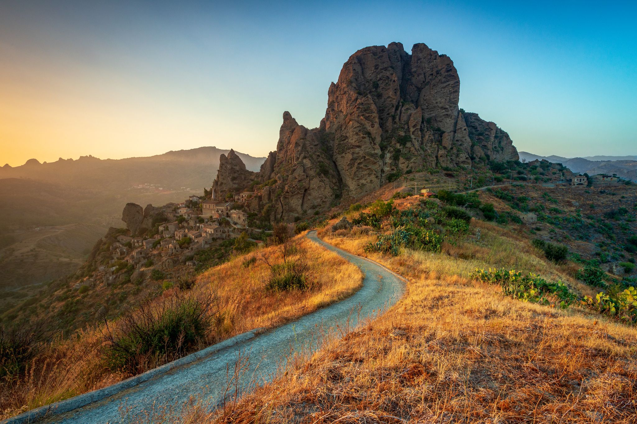
Situated at 250 metres above sea level, Pentidattilo stands perched on the cliff of Monte Calvario, with a characteristic shape that resembles that of a cyclopean hand with five fingers, and from which the name of the village derives in Greek πέντα-δάκτυλος (transliterated pènta-dàktylos), meaning "five fingers". The ancient village, which stood at 320 metres above sea level, was definitively abandoned in 1971, after having been declared uninhabitable three years earlier: the population, in fact, had migrated slightly towards the valley, forming a new small centre from which the old ghost town could be admired. Only recently have some artisans restarted some shops, to which a small restaurant has even been added. The village has undergone some redevelopment works, such as the restoration of some buildings, in addition to the resurfacing of the main street. Every summer Pentidattilo is a stop of the travelling festival Paleariza, an event of Greek culture on the international scene. Between August and September it also hosts the Pentedattilo Film Festival, an international short film festival. Source Wikipedia
0
0


The step of the Zita or "the step of the fiancée" tells a sad story from the Middle Ages of the death of a girl named Caterina. The story tells of a girl who kills herself because she doesn't want to marry the man chosen for her. Legend says that she was in love with someone else.
5
0
From Amendolea you can admire the spectacular panorama of the fiumara and the mountains that surround the town. In the distance you can also see the Tyrrhenian Sea.
5
0

Roccaforte del Greco, nestled in the Ellenofona area, fascinates with unique views and architecture rich in history. The village and its Church of the Holy Spirit are jewels of traditions and stories.
3
0
Frequently Asked Questions
What kind of terrain can I expect on no-traffic road cycling routes around Melito Di Porto Salvo?
The region offers a diverse range of terrain, from coastal roads with gentle gradients to challenging ascents into the Aspromonte Mountains. While many routes feature paved surfaces, some segments, particularly in more rugged areas, may be unpaved. You can find routes like the easy Pentedattilo Village loop from Melito di Porto Salvo with moderate elevation, or more demanding options such as the Gallicianò Village – Passo della Zita loop from Condofuri which features significant elevation gains.
Are there any easy, no-traffic road cycling routes suitable for beginners in Melito Di Porto Salvo?
Yes, there are options for beginners looking for traffic-free road cycling. The Pentedattilo Village loop from Melito di Porto Salvo is classified as easy, covering about 15.8 km with a manageable elevation gain of around 267 meters. This route allows you to enjoy the scenery without excessive physical demands.
What are some notable landmarks or attractions I can see along these routes?
Many routes offer stunning views and pass by significant landmarks. For instance, the Pentedattilo Village loop takes you past the fascinating Pentedattilo Village on Monte Calvario and Mount Calvario itself. Other routes might offer views of the Amendolea and the Aspromonte Mountains or the Amendolea River.
When is the best time of year to enjoy traffic-free road cycling in Melito Di Porto Salvo?
The region benefits from a Mediterranean climate. Spring (April-May) and Autumn (September-October) are generally ideal, offering pleasant temperatures and less intense sun, making for comfortable cycling conditions. Summer can be hot, especially on coastal routes, but mountain routes provide cooler temperatures. Winter cycling is also possible, though some higher mountain passes might be affected by weather.
Are there any challenging car-free road bike trails for experienced cyclists?
Absolutely. For experienced cyclists seeking a challenge, routes like the Gallicianò Village – Passo della Zita loop from Condofuri offer a demanding experience. This route spans nearly 70 km with over 2200 meters of elevation gain, providing a significant test of endurance and rewarding panoramic views. Another challenging option is the Faro di Capo dell'Armi loop from Motta San Giovanni - Lazzaro, featuring over 900 meters of ascent.
Can I find circular no-traffic road bike loops in the area?
Yes, several routes are designed as loops, allowing you to start and end in the same location without retracing your path. Examples include the easy Pentedattilo Village loop from Melito di Porto Salvo and the more challenging Gallicianò Village – Passo della Zita loop from Condofuri. These circular routes are excellent for exploring the diverse landscapes of the region.
What is the typical duration for these traffic-free road cycling routes?
The duration varies significantly based on the route's length and difficulty, as well as your cycling pace. An easy route like the Pentedattilo Village loop can take around an hour, while more difficult and longer routes, such as the Gallicianò Village – Passo della Zita loop, may require several hours to complete.
Are there any family-friendly no-traffic road bike trails in Melito Di Porto Salvo?
For families, the easier, shorter routes with less elevation are most suitable. The Pentedattilo Village loop from Melito di Porto Salvo is a good option, offering a manageable distance and elevation for a pleasant family outing. Always check the route details for specific terrain and elevation to ensure it matches your family's capabilities.
Where can I find parking for these road bike trails?
Parking availability varies by starting point. For routes originating from towns like Melito di Porto Salvo or Condofuri, you can typically find public parking areas within the village or near the start of the route. It's advisable to check local parking regulations and availability for your chosen starting location.
What kind of views can I expect on these routes?
The routes around Melito di Porto Salvo offer breathtaking and varied views. You can expect stunning vistas of the Ionian coastline, the crystal-clear sea, and dramatic transitions to the rugged, forested landscapes of the Aspromonte National Park. Many elevated points provide panoramic views of the Strait of Messina and even the distant Aeolian Islands on clear days.
Are there opportunities to connect with the wider Calabria Parks Cycle Network from Melito Di Porto Salvo?
Melito di Porto Salvo is strategically located to access the broader cycling opportunities in Calabria. The region is part of the developing Calabria Parks Cycle Network (Ciclovia dei Parchi della Calabria), an extensive route connecting four national parks. While specific direct connections from these no-traffic routes may vary, the general area is increasingly recognized as a prime destination for cyclists looking to explore this impressive network. You can find more information about the network on Italia.it.
What makes Melito Di Porto Salvo a good base for road cycling?
Melito di Porto Salvo offers a unique advantage as a cycling base due to its proximity to both the Ionian coastline and the Aspromonte National Park. This allows cyclists to easily choose between coastal rides and challenging mountain ascents, often within the same day. The focus on developing low-traffic routes further enhances its appeal for road cyclists seeking serene and scenic experiences.
Most popular attractions around Melito Di Porto Salvo

Get inspired with the komoot mobile app


Explore more
Browse the best Road cycling routes in other regions.
