The best hikes from bus stations around Halterner Stausee
4.6
(20600)
76,548
hikers
460
hikes
Bus station hiking trails around Halterner Stausee are characterized by diverse landscapes, including two large reservoirs, extensive heathland, and dense forests. The region features the Halterner Stausee and Hullerner See, offering waterside paths and scenic views. Areas like Westruper Heide present ancient cultural landscapes with heath and sand dunes, while the Haard Forest provides opportunities for varied forest hikes. The Stever River connects the reservoirs, adding to the network of accessible routes.
Best bus station hiking trails around Halterner Stausee
…Last updated: May 17, 2026
4.6
(67)
228
hikers
7.67km
01:57
30m
30m
Easy hike. Great for any fitness level. Easily-accessible paths. Suitable for all skill levels.
4.7
(23)
51
hikers
Easy hike. Great for any fitness level. Easily-accessible paths. Suitable for all skill levels.

Sign up for free
4.0
(11)
61
hikers
6.54km
01:40
20m
20m
Easy hike. Great for any fitness level. Easily-accessible paths. Suitable for all skill levels.
4.7
(18)
139
hikers
Easy hike. Great for any fitness level. Easily-accessible paths. Suitable for all skill levels.
5.0
(1)
24
hikers
Easy hike. Great for any fitness level. Easily-accessible paths. Suitable for all skill levels.
Get access to more routes and recommendations from other explorers.
Sign up for free
Already have an account?
Our route recommendations are based on thousands of hikes, rides, and runs completed by other people on komoot.
Start today with a free account
Your next adventure awaits.
Login or Signup
Other adventures around Halterner Stausee


Tips from the Community


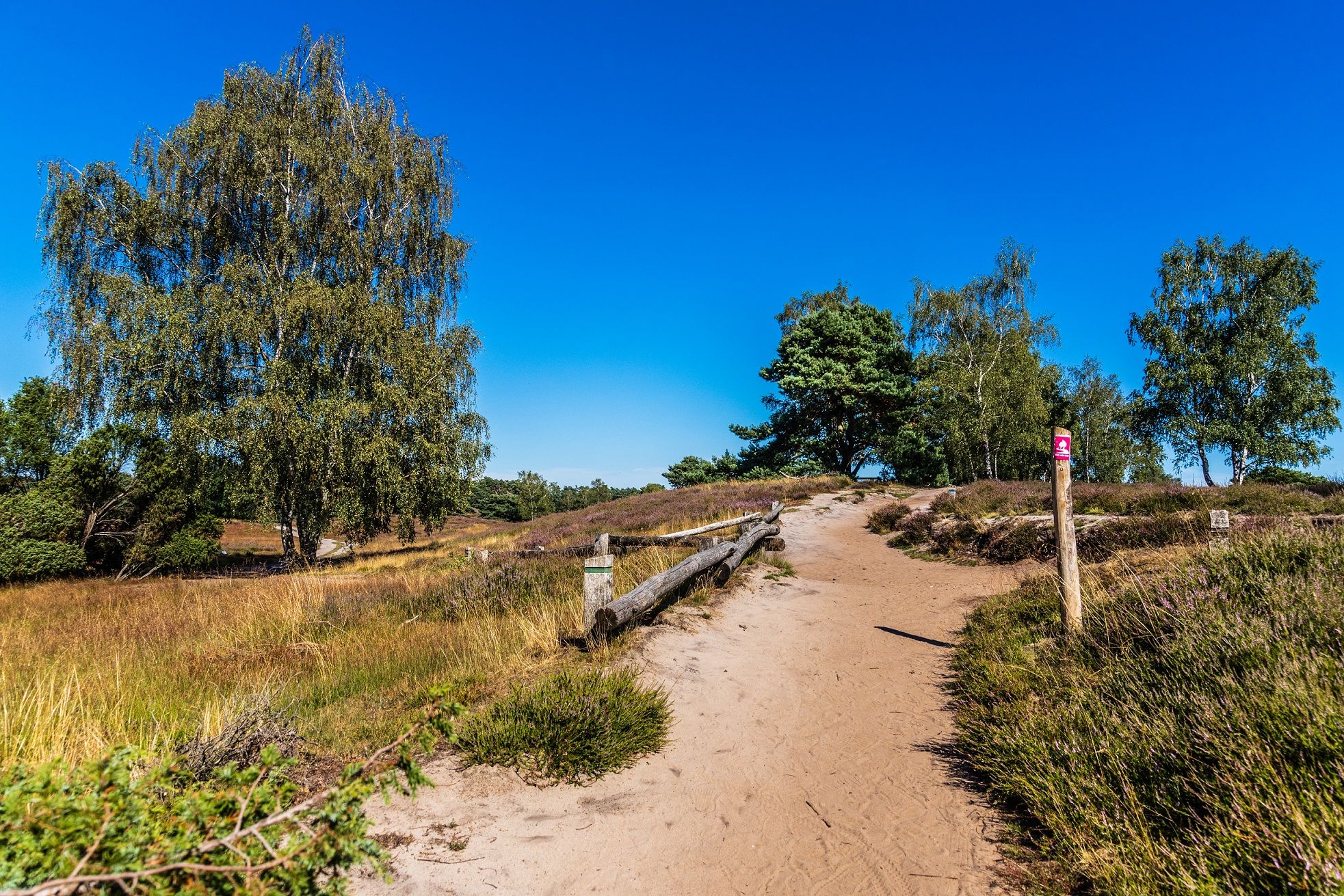
When the heather is in bloom, a visit is especially worthwhile!
0
0
When the heather is in bloom, a visit is especially worthwhile!
0
0
When the heath is in bloom, a visit to the Westrup Heath is especially worthwhile!
1
0

We read it here: ferry dock. But we couldn't really imagine how or where the ferry could dock here.
0
0

The Westrup Heath In the immediate vicinity of the Haltern Reservoir, the approximately 90-hectare Westrup Heath stretches across dune terrain. This impressive heathland was declared a nature reserve in 1937 and is now a popular tourist destination. Thousands of visitors each year stroll along the sandy paths through the heather, sandy grasslands, and bizarre juniper groves of one of the last great dwarf shrub heaths in Westphalia. Starting from the hiking car parks on Hullerner Straße and Flaesheimer Damm, there are several entry points into the Westrup Heath. For people with limited mobility or visual impairments, the Westrup Heath has also had an accessible route since 2010, starting from the Hotel Seehof, Hullerner Straße 102. Attractive information points also provide information about the heath's special features. See: https://westruper-heide.de/
1
0

A beautiful heath landscape that Ruhr area residents wouldn't expect to find here. A highlight...
1
0
Frequently Asked Questions
How many bus station hiking trails are available around Halterner Stausee?
There are over 450 hiking routes accessible from bus stations around Halterner Stausee. The majority, more than 330, are rated as easy, making the area very welcoming for casual hikers and families.
Are there any easy, circular routes accessible by bus for beginners or families?
Yes, many routes are easy and circular. For example, the West Shore Park, Haltern am See – Ferry Dock – Halterner Reservoir loop is an easy 4.4 km walk, perfect for a relaxed outing. Another option is the Stadtmühlen Bay Marina – Path Along the Railway Line loop, which is just under 4 km.
What natural attractions can I see along bus-accessible hiking trails?
The trails often lead past significant natural features. You can explore the unique heathland landscapes of Westruper Heide, especially vibrant with purple flowers from July to September. Many routes also offer views of the Halterner Reservoir and Hohe Niemen Bay, or follow the scenic Stever River.
Are there any historical or cultural landmarks near the bus station trails?
Yes, some trails incorporate historical elements. You might encounter the Neanderthal Site and Waterworks at Haltern am See, or pass through charming villages like Flaesheim with its old half-timbered houses. The region also has a Roman past, which can be explored further at the LWL Roman Museum.
Can I bring my dog on the bus-accessible hiking trails?
Many trails around Halterner Stausee are dog-friendly, offering plenty of space for your canine companion. Always keep your dog on a leash, especially in nature reserves like Westruper Heide, and be mindful of local regulations. The diverse landscapes, from forests to lakeside paths, provide varied terrain for walks with your dog.
What is the best time of year to hike these trails?
Halterner Stausee offers a refreshing escape year-round due to its mild climate. Spring brings lush greenery, while autumn showcases beautiful foliage. The Westruper Heide is particularly stunning between July and September when the heather blooms purple. Even in winter, the quiet, forested paths offer a peaceful hiking experience.
Are there any viewpoints or scenic spots easily reachable from bus stops?
Absolutely. Many routes provide excellent views of the reservoir. For instance, the View of the Haltern Reservoir loop from Westruper Heide is an easy 6 km trail specifically designed to offer continuous scenic vistas of the lake and surrounding nature.
What do other hikers enjoy most about hiking in Halterner Stausee?
The area is highly rated by the komoot community, with an average score of 4.6 stars from nearly 20,000 ratings. Reviewers often praise the diverse landscapes, the well-maintained paths, and the tranquil atmosphere, especially around the lakes and heathlands. The accessibility by public transport is also frequently highlighted as a major benefit.
Are there longer, more challenging bus-accessible routes for experienced hikers?
While many routes are easy, the region also offers moderate options. The Hohe Mark Nature Park, where Halterner Stausee is located, features sections of the 150 km Hohe Mark Steig long-distance trail. These longer segments, accessible from various points, provide more demanding hikes through varied terrain including forests and along the Stever River.
Can I find places to eat or rest along the bus station hiking trails?
Yes, several routes pass by opportunities for refreshments. You'll find Biergartens and cafes, particularly around the Halterner Stausee itself, allowing you to relax and recharge during or after your hike. The town of Haltern am See also offers various dining options easily reachable from bus stops.
Are there specific trails that showcase the Westruper Heide?
Yes, to experience the unique Westruper Heide, consider the Westrup Heath – Westruper Heath loop from Westruper Heide. This 7.6 km easy route takes you directly through the heathland, allowing you to admire its distinctive juniper bushes and, in late summer, the vibrant purple heather.
Most popular routes around Halterner Stausee
Most popular attractions around Halterner Stausee

Get inspired with the komoot mobile app


Explore more
Browse the best Hikes in other regions.
