Top 9 Natural Monuments in Mt. Shasta Wilderness
Best natural monuments in Mt. Shasta Wilderness include a diverse range of geological and ecological features. The region is dominated by Mount Shasta, an active volcano soaring to 14,179 feet, which is the second-highest peak in the Cascade Range. This landscape showcases ancient lava flows, glaciers, and unique alpine meadows. Visitors can experience varied ecosystems and significant geological formations resulting from past volcanic activity.
Best natural monuments in Mt. Shasta Wilderness
- The most popular natural monument is Mt Shasta summit…
Last updated: May 17, 2026
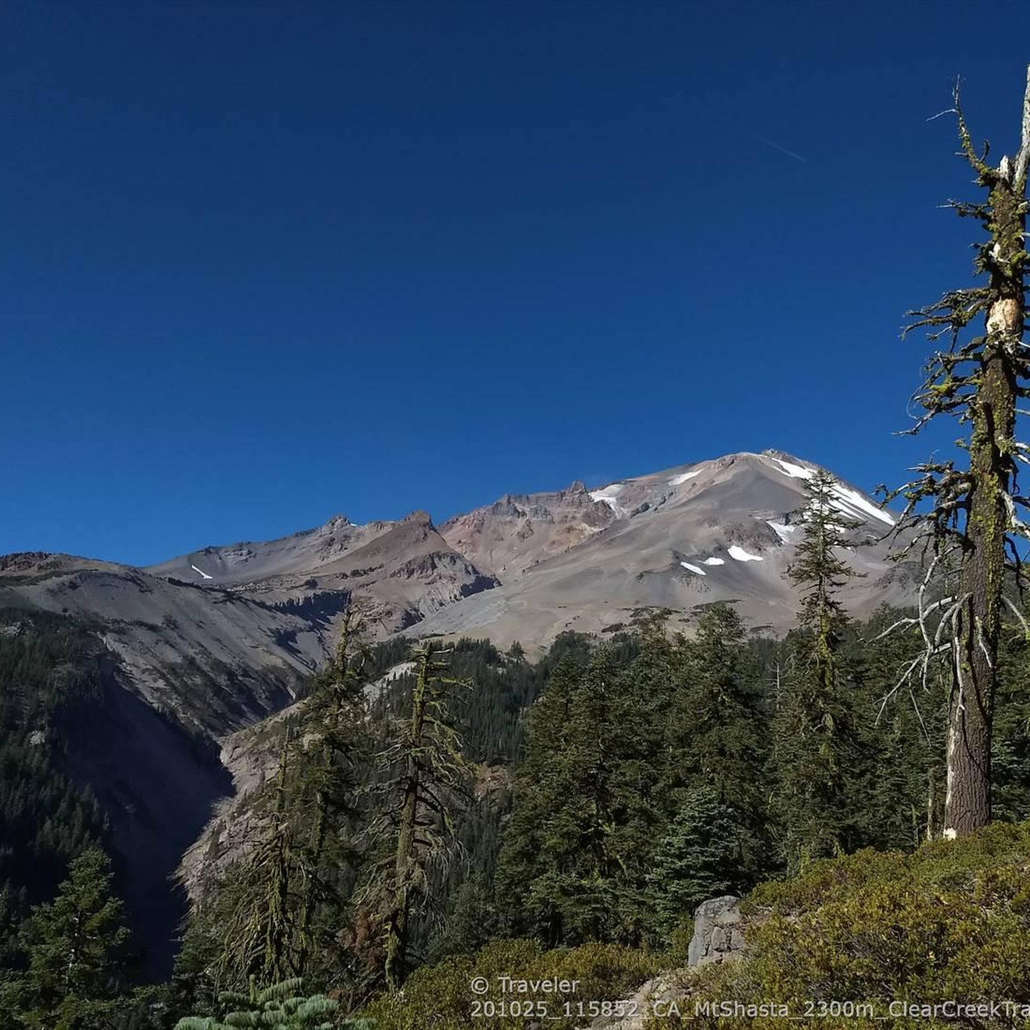
Mt Shasta summit 🌋 (4321m)
Highlight • Summit
For a winter snowshoe/crampon ascent route via Casaval Ridge and descent via standard Avalanche Gulch route see: komoot.com/tour/9090975
For an AT ski ascent …
Tip by

Olberman's Causeway - Mt Shasta
Highlight • Trail
Tip by
Sign up now to discover places like this
Get recommendations on the best single tracks, peaks, & plenty of other exciting outdoor places.
Sign up for free
Avalanche Gulch 🌋 Mt Shasta
Highlight • Climb
Tip by
Sulphur Hot Springs
Highlight • Natural Monument
Tip by
Olberman Causeway
Highlight (Segment) • Trail
Tip by
Sign up for free to discover even more natural monuments in Mt. Shasta Wilderness.
Sign up for free
Already have an account?
Start today with a free account
Your next adventure awaits.
Login or Signup
Popular around Mt. Shasta Wilderness
Tips from the Community

A long section of the trail from the Sierra Club hut up into Avalanche Gulch is nicely built like a causeway between lines of rock, carefully arranged over may years by the former guardian living at the Sierra Club hut at Horse Camp. It is snow free by summer, but at that time Avalanche gulch is usually avoided due to frequent dangerous loose rock fall. It is safer when the snow holds down the rocks. Bring crampons, and something like a plastic bag to sit on for glissading downhill on the return ;-)
1
0
You can still smell the strong sulphur in the steam venting out from several locations on the plateau, but there is currently not enough water rising to form a pool. Over a hundred years ago John Muir apparently saved himself and a companion by lying on the heat from the steam when forced by weather to overnight on the plateau without a tent or sleeping bag, but that wouldn't be enough heat currently. Several simple stone wall circles provide some limited wind protection.
0
0
In the fall you can literally hike up to the summit of this tallest free-standing mountain in the lower US via the eastern route without climbing or any snow. The standard Avalanche Gulch route would be too dangerous without snow due to frequent life-threatening rockfall.
2
1
Olberman's Causeway is a path built over many years by the guard living at the Sierra Club's Horse Camp Hut; it leads up Avalanche Gulch to the standard route to climb Mt Shasta. It is typically not visible under the snow in spring/early summer when it is safer to climb as long as snow holds the loose rocks in place that pose a severe rock fall danger (helmets are essential here). Most people camp around 10000 feet at Lake Helen on Day 1 and summit the next morning. For a winter route climbing from Horse Camp via Casaval Ridge and descending via Avalanche Gulch see: https://www.komoot.de/tour/9090975
0
0
Avalanche Gulch is the standard route to climb Mt Shasta, typically done in spring/early summer as long as snow holds the loose rocks in place that pose a severe rock fall danger (helmets are essential here). Most people camp around 10000 feet at Lake Helen on Day 1 and summit the next morning. For a winter route climbing from Horse Camp via Casaval Ridge and descending via Avalanche Gulch see: https://www.komoot.com/tour/9090975
0
0
Tallest free standing Cascade volcano in California. For a winter snowshoe/crampon ascent route via Casaval Ridge and descent via standard Avalanche Gulch route see: https://www.komoot.com/tour/9090975 For an AT ski ascent and descent via West Face see: https://www.komoot.com/tour/9089213 For the least technical snow-free route via Clear Creek Trail see https://www.komoot.com/tour/277653983
2
0
Mount Shasta (Karuk: Úytaahkoo or "White Mountain") is a potentially active volcano located at the southern end of the Cascade Range in Siskiyou County, California. At an elevation of 14,179 feet (4321.8 m), it is the second highest peak in the Cascades and the fifth highest in California. Mount Shasta has an estimated volume of 85 cubic miles (350 km3), which makes it the most voluminous stratovolcano in the Cascade Volcanic Arc. Shasta dominates the northern California landscape. It rises abruptly and stands nearly 10,000 ft (3,000 m) above the surrounding terrain. On a clear winter day, snowy Mount Shasta can be seen from the floor of the Central Valley 140 miles (230 km) to the south. The mountain consists of four overlapping volcanic cones that have built a complex shape, including the main summit and the prominent satellite cone of 12,330 ft (3,760 m) Shastina, which has a visibly conical form. If Shastina were a separate mountain, it would rank as the fourth-highest peak of the Cascade Range (after Mount Rainier, Rainier's Liberty Cap, and Mount Shasta itself). Mount Shasta's surface is relatively free of deep glacial erosion except, paradoxically, for its south side where Sargents Ridge runs parallel to the U-shaped Avalanche Gulch. This is the largest glacial valley on the volcano, although it does not presently have a glacier in it. There are seven named glaciers on Mount Shasta, with the four largest (Whitney, Bolam, Hotlum, and Wintun) radiating down from high on the main summit cone to below 10,000 ft (3,000 m) primarily on the north and east sides. The Whitney Glacier is the longest, and the Hotlum is the most voluminous glacier in the state of California. Three of the smaller named glaciers occupy cirques near and above 11,000 ft (3,400 m) on the south and southeast sides, including the Watkins, Konwakiton, and Mud Creek glaciers. https://en.wikipedia.org/wiki/Mount_Shasta
1
0
Frequently Asked Questions
What are some of the most striking natural monuments in the Mt. Shasta Wilderness?
The region is dominated by Mt Shasta summit 🌋 (4321m), an active volcano and the second-highest peak in the Cascades. Other notable features include the challenging Avalanche Gulch 🌋 Mt Shasta climbing route, and the unique Sulphur Hot Springs, where steam vents from the plateau. Beyond the immediate wilderness, the dramatic granitic spires of Castle Crags and the ancient formations within Lake Shasta Caverns are also significant natural attractions in the broader region.
What is the best time of year to visit the natural monuments in Mt. Shasta Wilderness?
The best time to visit largely depends on your desired activity. For climbing Mount Shasta, spring or early summer is ideal when snow helps stabilize loose rocks on routes like Avalanche Gulch. Wildflowers are vibrant in Panther Meadow from mid-July to November. For general hiking and enjoying the diverse ecosystems, late spring through early fall offers pleasant conditions. Winter provides opportunities for snowshoeing and crampon ascents, but requires specific gear and experience.
Are there any family-friendly natural monuments or activities in the Mt. Shasta Wilderness area?
While many routes on Mount Shasta are challenging, the broader Mt. Shasta region offers family-friendly options. Panther Meadow provides a tranquil setting for easy walks and reflection. Nearby, Castle Lake and Lake Siskiyou are excellent for swimming, kayaking, and paddleboarding. For easy hikes, consider trails like Green Butte Trail Loop or South Gate Meadows Trail, which are listed in the Easy hikes in Mt. Shasta Wilderness guide.
What kind of geological features can I expect to see in the Mt. Shasta Wilderness?
The Mt. Shasta Wilderness is a landscape shaped by volcanic activity. You'll encounter ancient lava flows, seven glaciers (most visible in late summer and fall), and the prominent stratovolcano of Mount Shasta itself. Features like Sulphur Hot Springs showcase ongoing geothermal activity. The nearby Castle Crags feature dramatic granitic spires, while Lake Shasta Caverns offer intricate stalactites and stalagmites from 250-million-year-old formations.
Are permits required to visit natural monuments or hike in the Mt. Shasta Wilderness?
Yes, permits are often required, especially for climbing Mount Shasta. A wilderness permit is generally needed for overnight stays and for climbing above 10,000 feet on Mount Shasta. Specific climbing permits may be required for summit attempts. It's advisable to check the Shasta-Trinity National Forest website or local ranger stations for the most current permit requirements before your visit, especially for activities like climbing or extended backcountry trips.
What are the rules regarding dogs in the Mt. Shasta Wilderness natural monuments?
Dog regulations vary within the Mt. Shasta Wilderness and surrounding areas. Generally, dogs must be on a leash in developed recreation areas and trailheads. In designated wilderness areas, dogs are often allowed but must be under strict voice control or on a leash to protect wildlife and ensure the wilderness experience for others. Always pack out pet waste. Specific rules may apply to certain trails or sensitive areas, so it's best to confirm with the Shasta-Trinity National Forest service for the specific monument you plan to visit.
Where can I find parking access for natural monuments in the Mt. Shasta Wilderness?
Parking is available at various trailheads leading into the wilderness and to specific natural monuments. For Mount Shasta, common access points include the Bunny Flat Trailhead and the Everett Memorial Highway, which leads to Panther Meadow. For other attractions like Castle Crags, designated parking lots are available at the state park. Always check for any parking fees or specific regulations for the area you intend to visit.
What outdoor activities can I do near the natural monuments in Mt. Shasta Wilderness?
Beyond exploring the monuments themselves, the area offers a wide range of outdoor activities. Hiking is very popular, with options from easy strolls to challenging climbs. You can find detailed routes in guides like Hiking in Mt. Shasta Wilderness, which includes trails like Clear Creek Trail and Mount Shasta via Avalanche Gulch Route. Other activities include mountaineering, rock climbing at Castle Crags, and water sports on Castle Lake and Lake Siskiyou.
Are there any easy hiking trails near the Mt. Shasta natural monuments for beginners?
Yes, there are several easy hiking trails suitable for beginners or those looking for a less strenuous experience. The Easy hikes in Mt. Shasta Wilderness guide features routes such as the Green Butte Trail Loop, South Gate Meadows Trail, and Old Ski Bowl Trail. These trails offer beautiful scenery without the demanding elevation gain of summit routes.
What is the spiritual or cultural significance of Mount Shasta?
Mount Shasta holds profound spiritual significance for many, including various Native American tribes who consider it a sacred place. It is also a focal point for New Age spiritual beliefs, with many believing it to be a source of mystical energy. Visitors often come seeking spiritual experiences, reflection, and connection with nature, drawn by the mountain's majestic presence and serene environment.
What wildlife might I spot around the natural monuments in Mt. Shasta Wilderness?
The diverse ecosystems of the Mt. Shasta Wilderness support a variety of wildlife. You might spot deer, black bears, and various ground squirrels. Birdwatchers can look for species adapted to alpine and forest environments. Observing wildlife often requires patience and quiet, especially in less frequented areas. Remember to maintain a safe distance and never feed wild animals.
Where are the best viewpoints to see Mount Shasta and its natural monuments?
Mount Shasta itself is a dominant feature visible from hundreds of miles. Excellent viewpoints include various points along the Everett Memorial Highway, especially leading up to Panther Meadow, which offers stunning perspectives of the mountain. Lake Siskiyou also provides picturesque views of Mount Shasta. For panoramic vistas of the surrounding wilderness, reaching higher elevations on trails or viewpoints within Castle Crags offers unique perspectives.
Most popular routes in Mt. Shasta Wilderness
Most popular attractions in Mt. Shasta Wilderness

Get inspired with the komoot mobile app


Explore more
Extend your search for the best caves by checking out these guides of the top ones in Mt. Shasta Wilderness:
