Black Canyon Of The Gunnison Wilderness
Black Canyon Of The Gunnison Wilderness
Top 8 Gorges in Black Canyon Of The Gunnison Wilderness
Best canyons in Black Canyon Of The Gunnison Wilderness are characterized by extreme depth, narrowness, and sheer, ancient rock walls carved by the Gunnison River. This federally designated wilderness area offers a primitive and unconfined recreational experience. The terrain includes metamorphic rock nearly two billion years old, with walls plunging over 2,000 feet in some areas. Inner canyon travel provides a unique perspective of the immense scale and geological grandeur.
Best canyons in Black Canyon Of The Gunnison Wilderness
- The…
Last updated: June 30, 2026
Warner Point Nature Trail
Highlight (Segment) • Trail
Tip by

South Rim Visitor Center, Black Canyon of the Gunnison National Park
Highlight • Rest Area
Tip by
Sign up now to discover places like this
Get recommendations on the best single tracks, peaks, & plenty of other exciting outdoor places.
Sign up for free
Gunnison Route (Black Canyon of the Gunnison Wilderness)
Highlight (Segment) • Trail
Tip by
Green Mountain Summit
Highlight • Summit
Tip by
Oak Flat Loop Trail
Highlight (Segment) • Trail
Tip by
Sign up for free to discover even more gorges in Black Canyon Of The Gunnison Wilderness.
Sign up for free
Already have an account?
Start today with a free account
Your next adventure awaits.
Login or Signup
Popular around Black Canyon Of The Gunnison Wilderness
Tips from the Community

A short and fairly easy hiking loop from the visitor center. There is definitely a couple of steep sections, though! This is why I recommend hiking CCW.
0
0
Green Mountain is the only 'summit' hike in Black Canyon National Park which gives you a different perspective of the canyon than any other hike in the park. Views of the canyon are not as immersive as when you are up close but it does give you an opportunity to get a view of the entire park and canyon at once. On the way to Green Mountain, you'll pass Exclamation Point, which is a fantastic viewing point of the canyon up close.
1
0
The Visitor Center is open year-round, but be aware that the opening times can vary by season. As with most NPS Visitor Centers, you can expect rangers, exhibits, and a bookstore. The visitor center is located near multiple hiking trails, including Gunnison Route and Tomichi Route that require Wilderness Permits which are available in limited quantities here. There is also a self-registration kiosk for this purpose in case the Visitor Center is closed. Keep in mind that during the summer the parking lot might be full.
1
0
If you want to hike to the inner canyon you need a wilderness permit, which can be obtained at the South Rim Visit Center, and the right gear to get down there. Microspikes are recommended during early spring, fall, and winter. Hiking poles can also be very useful. If you plan to camp at the river, don't forget your overnight gear. That being said, this is the easiest of all the inner canyon hikes. This is the only hike that takes you to the canyon floor that offers a chain to help on steeper sections. That does not mean this is for everybody. It is still a very tough and strenuous hike/scramble. The Gunnison Route is 1.5 miles long with a vertical drop of 1800 ft. Expect a round trip to be between 3 and 4 hours. For campers, there are 0.75 miles of river access, three campsites, and an outhouse upstream. Before you venture out on an inner canyon hike/scramble you have to realize they all come with a risk. They are very strenuous, there could be poison ivy everywhere, there are very loose rocks, big ledges to climb down and up to, and routing is difficult. Talk to a ranger and do your own research before doing them. Info about Wilderness Permits: https://www.nps.gov/blca/planyourvisit/innercanyon.htm
1
0
This is a wonderful hike with interpretive signs starting at the end of the South Rim Road. It might be a short distance to Warner Point, but it's not the easiest of trails and the heat also can play a major role in its difficulty. There are a bunch of shady benches spread out over the trail to catch your breath. Take every chance you get to enjoy the stunning views both north (West Elk Mountains), south (San Juan Mountain Range), and at the end of the trail (Gunnison River and the Black Canyon). Check out this walking guide for more info: https://www.nps.gov/blca/planyourvisit/upload/warner_trail_guide.pdf
2
0

Nice trail at the end of South Rim Road with great views and interesting trees
0
0
Frequently Asked Questions
How challenging are the canyons in Black Canyon Of The Gunnison Wilderness?
Exploring the inner canyons of Black Canyon Of The Gunnison Wilderness is exceptionally challenging. There are no maintained trails into the inner canyon; instead, visitors use designated wilderness routes which are strenuous, unmarked scrambles over loose dirt and rock. These routes require significant physical fitness, route-finding skills, and preparation for self-reliance. For example, the Gunnison Route, considered one of the 'easiest' inner canyon descents, still involves an 1800 ft vertical drop over 1.5 miles.
Do I need a permit to explore the inner canyons?
Yes, a wilderness use permit is required for all descents into the inner canyon. These permits are available in limited quantities at the South Rim Visitor Center or the North Rim Ranger Station. A self-registration kiosk is also available if the Visitor Center is closed. It's crucial to obtain one before attempting any inner canyon route.
What unique natural features can I expect to see in the Black Canyon Of The Gunnison Wilderness?
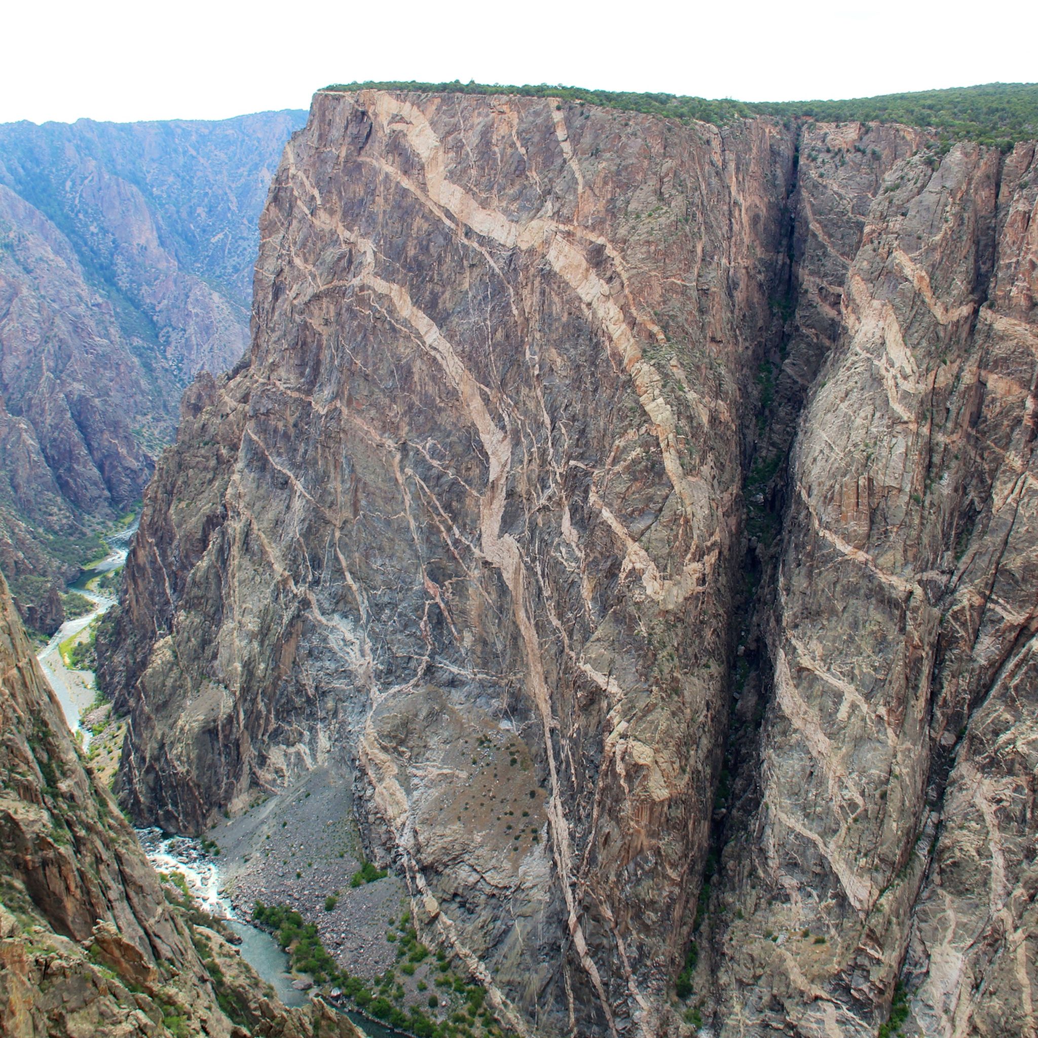
The Black Canyon is renowned for its extreme depth and narrowness, with walls plunging over 2,000 feet in some areas, sometimes only 40 feet wide at the river. You'll witness ancient metamorphic rock, nearly two billion years old, streaked with pink pegmatite intrusions, most famously on the 2,250-foot Painted Wall. The powerful Gunnison River and unique flora and fauna adapted to this extreme environment are also prominent features.
When is the best time to visit the canyons in Black Canyon Of The Gunnison Wilderness?
The best time to visit depends on your activity. Spring and fall offer milder temperatures, which can be ideal for strenuous inner canyon descents. Summer can be very hot, increasing the difficulty of routes. Winter brings snow and ice, requiring specialized gear like microspikes for inner canyon access. The South Rim Visitor Center is open year-round, but opening times vary seasonally.
Are there any family-friendly options for experiencing the canyons?
While inner canyon routes are not family-friendly due to their extreme difficulty, there are accessible options for families to experience the canyon's grandeur. The Warner Point Nature Trail offers interpretive signs and stunning views from the rim. The South Rim Visitor Center provides exhibits and easy access to rim trails, allowing families to enjoy panoramic views safely.
What are some of the most challenging inner canyon routes?
Among the most challenging inner canyon routes are the Gunnison Route (South Rim), which features an 1800 ft drop and a chain to aid passage; the Warner Route (South Rim), a longer 3.5-mile descent with over 2700 ft drop known for technical terrain; and the Tomichi Route (South Rim), the steepest with a 1960 ft drop in just one mile. On the North Rim, Pinyon Draw is also a very strenuous descent.
What should I wear and bring for hiking in the canyons?
For inner canyon hikes, wear sturdy hiking boots with good ankle support. Long pants and sleeves are recommended to protect against poison ivy and scrapes from loose rocks. Bring plenty of water, high-energy snacks, a map, compass or GPS, and a first-aid kit. Hiking poles are highly recommended for stability on steep, loose terrain. During colder months, microspikes may be necessary. Always check weather conditions before heading out.
What outdoor activities can I do near these canyons?
Beyond the challenging inner canyon descents, the Black Canyon Of The Gunnison Wilderness offers various outdoor activities. You can find numerous hiking opportunities, from easy rim trails to more strenuous routes. The Gunnison River within the canyon is designated Gold Medal Water, offering world-class trout fishing. For expert whitewater enthusiasts, the river also provides challenging boating experiences. You can explore more hiking options in the region via the Hiking in Black Canyon Of The Gunnison Wilderness guide.
Are there specific viewpoints to see the canyon's depth and geology?
Yes, several viewpoints offer spectacular perspectives. The Warner Point Nature Trail provides stunning views of the Gunnison River and the Black Canyon. For a unique, broader perspective of the entire park and canyon, consider the hike to Green Mountain Summit, which also passes Exclamation Point, another fantastic viewing spot. The South Rim Visitor Center area also provides access to multiple rim trails with impressive overlooks.
What do visitors enjoy most about Black Canyon Of The Gunnison Wilderness?
Visitors are captivated by the canyon's immense scale, extreme depth, and ancient geological formations. The primitive and unconfined recreational experience, offering solitude and a raw connection with nature, is highly valued. The unique perspective gained from descending into the canyon, witnessing the towering walls and the powerful Gunnison River up close, is a highlight for many. The interpretive signs along trails like the Warner Point Nature Trail also enhance the experience.
What is the geological significance of the Black Canyon?
The Black Canyon is a geological marvel, exposing metamorphic rock, including gneiss and schist, that is nearly two billion years old – among the oldest in North America. Intrusions of pink pegmatite streak the dark canyon walls, creating striking patterns. This ancient geology, combined with the immense erosive power of the Gunnison River, has carved a canyon that offers a profound sense of Earth's history and a unique 'vertical wilderness'.
Can I camp along the river in the inner canyon?
Yes, primitive camping is allowed along the Gunnison River in the inner canyon, but it requires a wilderness use permit. Specific routes like the Gunnison Route and Pinyon Draw offer designated primitive campsites. You must be prepared to carry all your gear down and back up, and practice Leave No Trace principles. Always check with a ranger for current regulations and conditions.
Most popular routes in Black Canyon Of The Gunnison Wilderness
Most popular attractions in Black Canyon Of The Gunnison Wilderness

Get inspired with the komoot mobile app


Explore more
Already discovered everything in this region? See additional gorges in Black Canyon Of The Gunnison Wilderness for your next adventure:
