Attractions and Places To See in the Kaiparowits Plateau - Top 8
Best attractions and places to see in the Kaiparowits Plateau are found within a remote and elevated landform in southern Utah, forming a significant part of the Grand Staircase–Escalante National Monument. This region is characterized by its rugged landscape, geological wonders, and cultural sites. Notable landmarks include impressive arches and prominent cliffs, alongside deeply dissected canyons. The plateau also contains significant paleontological and archaeological sites, offering insights into ancient life and past human occupation.
Best attractions and places to see in the Kaiparowits Plateau
- The most popular attractions is Yellow Rock Trail, a natural monument featuring a giant, multicolored hill of slick rock. From the top, hikers get expansive views of the surrounding mountains and rock formations.
- Another must-see spot is Grosvenor Arch, an impressive double arch measuring up to 30 meters in diameter. A short hiking trail leads to the base of this natural monument.
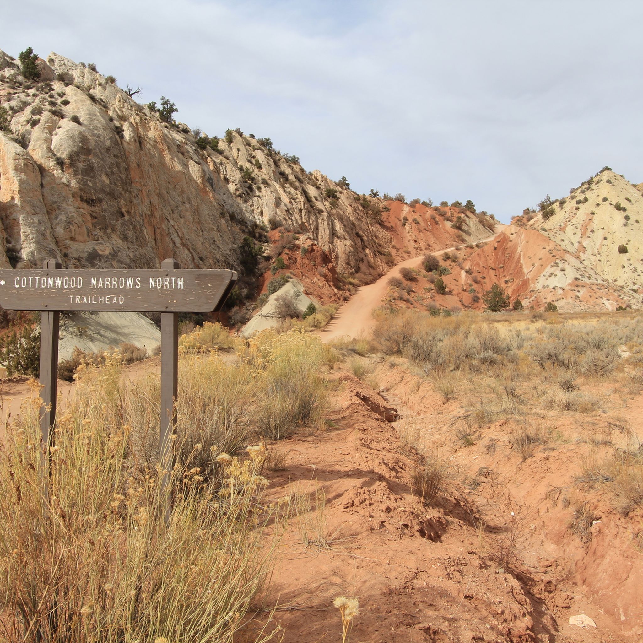
- Visitors also love Cottonwood Narrows South Trailhead, a canyon entrance along the Cottonwood Canyon scenic road. It offers a scenic experience walking between the cliffs.
- Kaiparowits Plateau is known for its natural monuments, canyons, and historical sites. The region offers a variety of attractions to see and explore, from geological formations to ancient cultural evidence.
- The attractions in the Kaiparowits Plateau are appreciated by the komoot community, with 2 upvotes and 9 photos shared by visitors.
Last updated: October 4, 2026
Grosvenor Arch
Highlight • Natural Monument
Tip by

Catstair Canyon Trail
Highlight (Segment) • Canyon
Along this trail, in the canyon, you will see a high canyon wall and two tall stacks of old, discarded cars. The cars were put in this area with plans for them to be used in the construction of the highway but that didn't pan out and the construction companies left them in the canyon.
Tip by

Sign up now to discover places like this
Get recommendations on the best single tracks, peaks, & plenty of other exciting outdoor places.
Cottonwood Narrows South Trailhead
Highlight • Canyon
Tip by

Grand-Staircase Escalante National Monument
Highlight • Natural Monument
To enter the National Monument you should have at least a 4x4 vehicle. Watch for the weather and avoid driving along the backcountry roads in rain.
Tip by
Paria
Highlight (Segment) • Historical Site
This trail leads to the abandoned western outpost that is Paria. The ghost town has since become the set for many western films, including Clint Eastwood's The Outlaw Josey Wales.
Tip by
Bull Valley Gorge
Highlight (Segment) • Gorge
Tip by
Lick Wash Trail
Highlight (Segment) • Trail
Tip by
Start today with a free account
Your next adventure awaits.
Popular around Kaiparowits Plateau
Tips from the Community

It is really beautiful to walk between the cliffs.
1
0

Ghost Town Paria trail can be sandy and muddy after heavy rains. The trail does not offer any coverage from the sun, so make sure to bring ample water. The trail is open to vehicles and there is a parking lot close to the ghost town but the road is often washed out beyond Paria Cemetery. This trail leads to the abandoned western outpost that is Paria. The ghost town has since become the set for many western films, including Clint Eastwood's The Outlaw Josey Wales.
0
0
Catstair Canyon Trail is a short trail, just off Highway 89. There are two parking lots that have entrances to this trail. There is a west parking lot and an east parking lot. The west parking lot entrance is much more accessible and does not require any kind of gear or rope to enter the canyon. The east entrance does require rope and has much steeper rocks directly at the entrance. Along this trail, in the canyon, you will see a high canyon wall and two tall stacks of old, discarded cars. The cars were put in this area with plans for them to be used in the construction of the highway but that didn't pan out and the construction companies left them in the canyon.
0
0
Lick Wash is a diverse trail with sections of close slot canyon walls, tall pines, and sandstone rock formations. Hikers can find pink pebbles and stones in the wash from the Pink Cliffs nearby.
0
0
Bull Valley Gorge is an interesting hike, due to the geology of the area as well as the evidence that remains from a car accident that happened over the gorge in the 1950s. A car hangs at the top of the deep gorge just off of the road, frozen in time.
0
0
The trail to Grosvenor Arch is very short and you can see the arches from afar in the parking lot. The rock that the double arch is in towers high above the desert. This arch is named after the first permanent editor of National Geographical Magazine. He was the editor-in-chief of the magazine for 55 years.
0
0

Cottonwood Narrows South entrance along the 45 miles Cottonwood Canyon scenic road.
2
0

The Grosvenor Arch measures up to 30 meters in diameter and is absolutely impressive. If you dare to take the Cottonwood Canyon Road in Grand-Staircase Escalante, you should visit the double arch. A short hiking trail leads to the foot of this fascinating natural monument. By the way, the Grosvenor Arch is named after Gilbert Hovey Grosvenor, the first permanent editor of the National Geographic Magazine. He headed the magazine as editor-in-chief for 55 years.
2
0
Frequently Asked Questions
What are the most popular natural landmarks in the Kaiparowits Plateau?
The Kaiparowits Plateau is home to several impressive natural landmarks. Among the most popular are Grosvenor Arch, an impressive double arch measuring up to 30 meters in diameter, and the Yellow Rock Trail, which leads to a giant, multicolored hill of slick rock offering expansive views. The region also features the distinctive Straight Cliffs, the Cockscomb ridge, and the intricate Deeply Dissected Canyons.
Are there any historical or cultural sites to visit in the Kaiparowits Plateau?
Yes, the Kaiparowits Plateau is rich in history. You can explore significant archaeological sites from the Anasazi and Fremont cultures, which provide insights into ancient settlement. Additionally, the area is renowned for its Late Cretaceous Period dinosaur fossils and paleontological sites. The ghost town of Paria, a former western outpost and film set, is another notable historical site.
What kind of outdoor activities can I do near the attractions in the Kaiparowits Plateau?
The Kaiparowits Plateau offers a variety of outdoor activities, primarily hiking and running. You can find numerous trails, including the Paria River Valley Trail and the Cottonwood Narrows Trail. For runners, there are routes like the Rimview Trail and scenic loops with views of Lake Powell.
What is the best time of year to visit the Kaiparowits Plateau?
Autumn is generally considered the best time to visit the Kaiparowits Plateau due to more stable weather conditions. Summer temperatures can be extremely high, often reaching 95 to 105 degrees Fahrenheit, making exploration challenging. Always be prepared for arid and remote conditions regardless of the season.
Are there family-friendly attractions or trails in the Kaiparowits Plateau?
While many areas are remote and rugged, some attractions can be enjoyed by families. The short hiking trail to the base of Grosvenor Arch is relatively easy. For hiking, there are also easy hikes available, such as the Ghost Town Pahreah Trail, which leads to the historical site of Paria.
What unique geological features can I expect to see?
The Kaiparowits Plateau is a geological marvel. Beyond the famous Grosvenor Arch, you'll find the striking Wahweap Hoodoos, prominent Straight Cliffs, and the distinctive Cockscomb ridge. The region is also characterized by deeply dissected canyons, including Rock, Last Chance, Warm, Wahweap, and Coyote Creeks, which now form major side channels of Lake Powell.
What are the access requirements for the Kaiparowits Plateau, especially for vehicles?
Due to the remote and rugged nature of the Kaiparowits Plateau, a high-clearance 4x4 vehicle is often required to access many areas, particularly along backcountry roads like Cottonwood Canyon Road and Hole-in-the-Rock Road. It's crucial to check weather conditions and avoid driving on unpaved roads during or after rain.
Are permits required for visiting or camping in the Kaiparowits Plateau?
Yes, if you plan on dispersed camping within the Grand Staircase–Escalante National Monument, which encompasses much of the Kaiparowits Plateau, a free backcountry permit is required. These permits can often be obtained at entrance roads from small boxes.
Where can I experience slot canyons in the Kaiparowits Plateau?
The Kaiparowits Plateau offers several opportunities to experience slot canyons. The Cottonwood Narrows South Trailhead provides a scenic walk between towering cliffs. Other notable canyons include Catstair Canyon, Bull Valley Gorge, and Lick Wash Trail, offering varying levels of challenge and beauty.
What should I know about safety and preparation when visiting this remote region?
Given the arid and remote nature of the Kaiparowits Plateau, preparation is key. Temperatures can be extreme, especially in summer, so bring ample water. There is often no phone service, so navigation skills are essential. A high-clearance 4x4 vehicle is frequently necessary for access. Always inform someone of your plans and expected return time.
What is the <a href="https://www.komoot.com/highlight/1046015" target="_blank" rel="noopener">Yellow Rock Trail</a> like?
The Yellow Rock Trail features a steep and strenuous climb up a giant, multicolored hill of slick rock. While challenging, the reward is expansive views of the surrounding mountains and rock formations from the top. Hikers should exercise caution on the descent due to the steepness and potential for loose rocks.
Can I find any unique ecosystems or woodlands in the area?
Yes, much of the Kaiparowits Plateau, covering approximately 1,650 square miles, is characterized by extensive Pinyon-Juniper Woodlands. These woodlands provide a distinct ecological feature and habitat within the arid landscape, offering a different natural experience compared to the rock formations and canyons.
Most popular routes in the Kaiparowits Plateau
Most popular attractions in the Kaiparowits Plateau

Get inspired with the komoot mobile app


Explore more
Still not found the Highlight you’re looking for? See guides of the top attractions in other regions:
