The best running trails around Portland
66
runners
8
runs
Jogging around Portland offers a diverse landscape for runners, featuring varied terrain from urban paths to routes with significant elevation changes. The region provides numerous opportunities for outdoor activity, with many routes including scenic viewpoints and following natural features like creeks and hills. Runners can find trails that traverse through areas with notable elevation gains, offering both physical challenge and expansive vistas.
Best jogging routes around Portland
- The most popular jogging route is Ouray loop from Ouray, a 4.3…
Last updated: May 11, 2026
17
runners
7.14km
00:45
80m
80m
Moderate run. Good fitness required. Mostly paved surfaces. Suitable for all skill levels.
13
runners
25.1km
03:16
1,050m
1,050m
Hard run. Very good fitness required. Sure-footedness, sturdy shoes and alpine experience required.

Sign up for free
8
runners
12.1km
01:26
390m
400m
Hard run. Very good fitness required. Mostly paved surfaces. Suitable for all skill levels.
7
runners
16.8km
03:07
1,380m
1,380m
Hard run. Very good fitness required. Mostly paved surfaces. Suitable for all skill levels.
7
runners
10.2km
02:01
890m
890m
Hard run. Very good fitness required. Mostly paved surfaces. Suitable for all skill levels.
Get access to more routes and recommendations from other explorers.
Sign up for free
Already have an account?
Our route recommendations are based on thousands of hikes, rides, and runs completed by other people on komoot.
Start today with a free account
Your next adventure awaits.
Login or Signup
Popular around Portland

Tips from the Community

Ouray ( YOOR-ay) is a home rule municipality that is the county seat of Ouray County, Colorado, United States. The city population was 898 as of the 2020 census. The Ouray Post Office has the ZIP Code 81427. Located at an elevation of 7,792 feet (2,375 m), Ouray's climate, natural alpine environment, and scenery have earned it the nickname "Switzerland of America".
0
0

A rugged mountain run that follows a tumbling creek through a narrow canyon, with steep walls rising on both sides. The sound of rushing water and glimpses of small cascades keep the climb lively, while the cool air from the creek offers relief on warm days. A tough but scenic stretch on the way to higher ground or to Ouray.
0
0
Small creek crossing that is part of the Oak Creek Trail. The water is normally shallow and slow moving, and with some strategically placed rocks, you can cross the creek without getting your feet too wet.
0
0
The Oak Creek Trail is a popular trail that passes several waterfalls and a creek. The trail has some moderate elevation gain, but it not too strenuous.
0
0
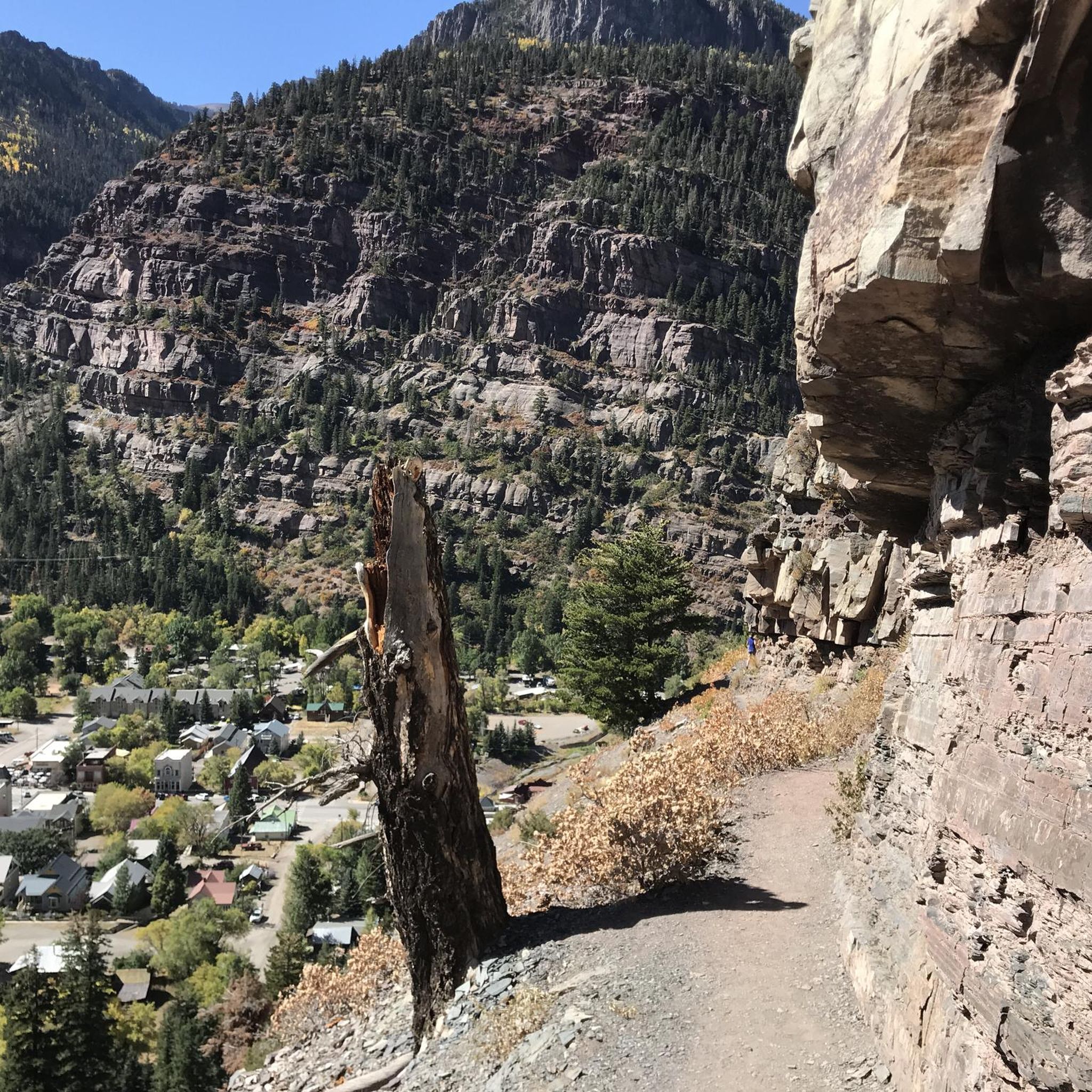
The Perimeter Trail is one of the main trail in Ouray and gives you great views of the town and mountains. There is also one of several via ferrata accesses here.
0
0

Nestled in the heart of the San Juan Mountains, Ouray, Colorado, is a haven for outdoor enthusiasts. Its rugged landscape offers hiking, rock and ice climbing (Ouray is known in particular for its ice park), road and mountain bike riding, and hot springs for those seeking adventure. The Uncompahgre River also attracts kayakers and fishing enthusiasts - there really is something here for everyone! The historic Main Street is a fantastic place to regroup, relax, and refuel after a busy day outside. Featuring Victorian-style architecture, local shops, and laid-back cafes and restaurants, this historic street is a great place to spend an afternoon.
0
0

Box Canyon Falls is where Canyon Creek cascades 85 feet into a narrow quartzite canyon surrounded by 100-foot walls. This developed park offers hiking trails, picnic areas, and a visitor center, which operates seasonally, closing in November. The park is also a significant bird area, recognized by the National Audubon Society for hosting Black Swifts, the largest swifts in North America, which migrate from Brazil each summer. Keep in mind that dogs are not allowed in the park.
0
0

This cliff is fairly clear of cars. Runners are often spotted running alongside this road. When taking pictures, watch out for oncoming vehicles
0
0
Frequently Asked Questions
What types of running trails can I expect around Ouray?
The Ouray area offers a diverse landscape for runners, featuring varied terrain from moderate loops to challenging trails with significant elevation changes. You'll find routes that traverse through canyon areas, along natural creek features, and to scenic viewpoints, providing both physical challenge and expansive vistas.
Are there any easy or beginner-friendly running routes in the Ouray region?
While many routes in the Ouray area feature significant elevation changes, there is at least one moderate option suitable for those looking for a less strenuous run. The Ouray loop from Ouray is a 4.3-mile (6.9 km) trail with a steady elevation gain of 237 feet (72 meters), making it a good choice for a moderate effort.
What are some of the more challenging running trails near Ouray?
For experienced runners seeking a challenge, the Ouray region has several difficult routes. The Canyon Creek – Camp Bird Road Scenic Outlook loop from Ouray is a demanding 15.6-mile (25.0 km) path with over 3,445 feet (1,050 meters) of climbing through canyon areas. Another difficult option is the Bridge of Heaven loop from Ouray, which features substantial elevation gain over 10.5 miles (16.8 km).
Are there any running routes with scenic viewpoints in the Ouray area?
Yes, many of the running routes around Ouray are known for their scenic viewpoints. For example, the Camp Bird Road Scenic Outlook – Ouray loop from Ouray is a 7.5-mile (12.0 km) trail that leads through varied terrain and offers beautiful outlooks.
What natural attractions can I see along the running trails near Ouray?
The Ouray region is rich in natural beauty. Along some routes, you might encounter stunning waterfalls like Canyon Creek Bridge and Falls and Lower Cascade Falls. There are also interesting structures such as the Sweet Bridge.
Are there any loop running trails available in Ouray?
Yes, several running trails in the Ouray area are designed as loops, offering a convenient way to explore without retracing your steps. Examples include the moderate Ouray loop from Ouray and the more challenging Sister Peak – Twin Peaks loop from Ouray.
What do other runners say about the trails in the Ouray region?
The running trails around Ouray are popular among the komoot community, with over 50 runners having explored the varied terrain. Users often highlight the significant elevation changes, scenic viewpoints, and natural creek features that define the region's routes.
How many running routes are featured in this guide for the Ouray area?
This guide features 6 distinct running routes around Ouray, offering a range of distances and difficulty levels for different preferences.
What is the best time of year for running in Ouray?
Ouray's mountainous terrain means that late spring through early fall typically offers the most favorable conditions for running, with milder temperatures and less snow. However, conditions can vary, so checking local weather and trail reports is always recommended.
Are there any running routes that pass through or near the town of Ouray itself?
Many routes in the area are named with 'Ouray' in mind, indicating their proximity or starting point from the town. For instance, the Ouray loop from Ouray is a prime example of a route that starts and ends near the settlement of Ouray.
Are there options for long-distance running in the Ouray region?
Yes, for those looking for longer runs, the Ouray area provides challenging options. The Canyon Creek – Camp Bird Road Scenic Outlook loop from Ouray is a substantial 15.6-mile (25.0 km) route, perfect for a longer endurance run.
Most popular routes around Portland
Most popular attractions around Portland

Get inspired with the komoot mobile app


Explore more
Browse the best Running Trails & Routes in other regions.
