The best cycling routes around Crane Creek
44
riders
4
rides
Touring cycling routes around Crane Creek traverse the high Sierra Nevada landscape, characterized by significant elevation changes, granite peaks, and deep glacial valleys. The region features iconic giant sequoia groves and alpine lakes, with routes often following scenic mountain roads. This area provides challenging climbs and expansive vistas for touring cyclists.
Best touring cycling routes around Crane Creek
- The most popular touring cycling route is From the Yosemite Valley to Glacier Point and back, a 50.2 miles (80.8 km)…
Last updated: June 29, 2026
26
riders
80.8km
05:49
1,770m
1,770m
Embark on a truly epic touring cycling adventure from the Yosemite Valley to Glacier Point and back, a difficult 50.2-mile (80.8 km) route that promises some of Yosemite's most breathtaking…
6
riders
93.2km
06:26
1,760m
1,760m
This difficult touring cycling route from Tuolumne Grove of Giant Sequoias to Olmsted Point via Tioga Road offers an epic journey through Yosemite's high country. You'll start among ancient sequoias,…

Sign up for free
1
riders
83.3km
05:53
1,690m
1,690m
Cycle 51.8 miles through Yosemite National Park, from Tuolumne Grove's giant sequoias to O'Shaughnessy Dam, gaining 5548 feet.
11
riders
151km
10:13
2,590m
2,590m
Hard bike ride. Very good fitness required. Mostly paved surfaces. Suitable for all skill levels.
Our route recommendations are based on thousands of hikes, rides, and runs completed by other people on komoot.
Start today with a free account
Your next adventure awaits.
Login or Signup
Popular around Crane Creek
Tips from the Community

The famous Tunnel View can get busy, but you can play your cards right and visit during the perfect time. Spring is when waterfalls flow strongly, and the late afternoon through sunset offers excellent lighting conditions.
1
0

Here the long distance Pacific Crest Trail, on its way between Mexico and Canada, crosses Tioga Road, with popular and convenient break options to hitchhike and explore the more developed portions of Yosemite National Park, and resupply on food and gear.
1
0

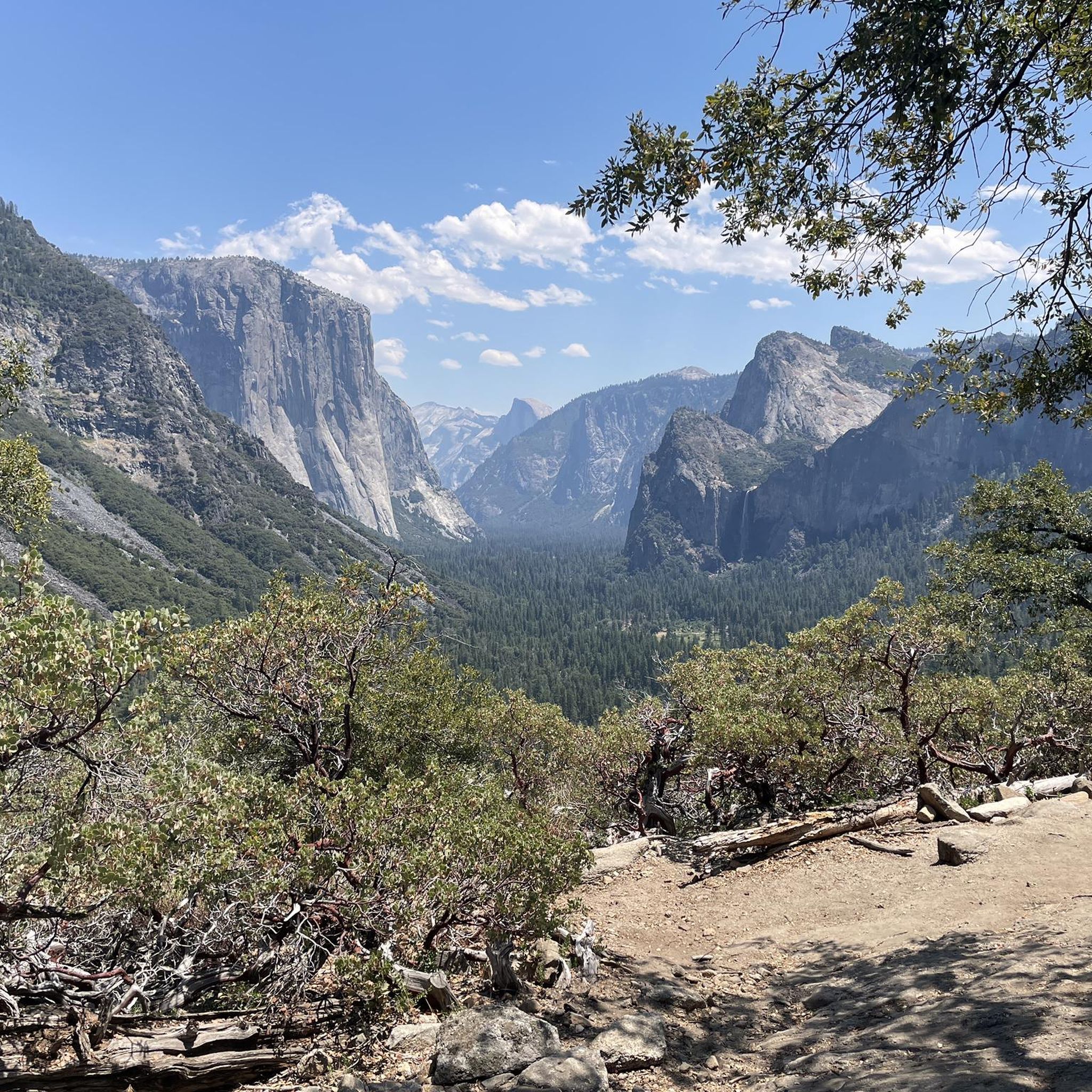
Tunnel View is one of Yosemite National Park’s most famous viewpoints. Located at the east end of Wawona Tunnel along Highway 41, it sits at about 4,500 feet in elevation and provides an iconic view over Yosemite Valley. To the left, El Capitan towers over the valley, while to the right, Bridalveil Fall cascades down its rocky cliffs. In the background, Half Dome dominates the horizon.
0
0

Crane Flat is at the intersection of Tioga Road and Big Flat Road. The little store attached to the gas station is well stocked and is a good place to fill up on any drinks or snacks you might need for the ride. The Yosemite branded trail mix is a personal favorite.
0
0
Tuolumne Meadows is one of the crown jewels of Yosemite National Park. The picturesque meadows are surrounded by the iconic granite domes that Yosemite is known for. The most notable being Lembert Dome that looms over the eastern edge of the meadows.
0
0
This winding, tree-lined road leads down to the Hetch Hetchy reservoir that now covers the valley that John Muir compared to its more famous neighbor, Yosemite Valley. Despite the famed conservationists valiant effort, the valley was dammed off to create a water source for the growing Bay Area population.
0
0
Tioga Road is one of the most iconic rides you can do within a National Park. Along this stretch of road you'll pass by a number of picturesque waterfalls, creeks, lakes, and the famous granite domes that Yosemite is known for. If you time it just right there is one weekend a year when bike travel is allowed before the road opens to cars after the long winter closure. Check https://istiogaopen.com/ to get notified for this event.
0
0
This is a great place to park for a ride on Tioga Road. The hike down to the Sequoia Grove is short but somewhat steep on the way back up. You should definitely check it out before or after your ride if you have the time. Crane Flat gas station is just around the corner and well stocked for drinks and snacks. Pro tip: The Yosemite branded trail mix is excellent, though not especially healthy.
0
0
Frequently Asked Questions
What kind of terrain can I expect on touring cycling routes around Crane Creek?
The touring cycling routes around Crane Creek are primarily located in the high Sierra Nevada. You can expect significant elevation changes, granite peaks, deep glacial valleys, and scenic mountain roads. The area is known for challenging climbs and expansive vistas.
Are there any easy or beginner-friendly touring cycling routes in Crane Creek?
The routes listed for touring cycling around Crane Creek are generally considered difficult, featuring substantial climbs and long distances. They are best suited for experienced cyclists seeking a challenge in a high mountain environment.
What are the typical distances and durations for touring cycling routes in this region?
The touring cycling routes around Crane Creek are long-distance, typically ranging from about 43 miles (69 km) to over 93 miles (150 km). Durations can vary from approximately 4 hours 44 minutes to over 10 hours, depending on the route and your pace.
What are some notable viewpoints or natural attractions along the touring cycling routes?
Many routes offer breathtaking views. For instance, the route From the Yosemite Valley to Glacier Point and back features a substantial climb to a prominent viewpoint. Other routes offer high-altitude scenery along mountain passes. Nearby attractions include the Tunnel Tree (Dead Giant) in Tuolumne Grove, Bridalveil Fall, and scenic spots like Inspiration Point and Valley View.
Can I find circular touring cycling routes in Crane Creek?
Yes, there are circular routes available. An example is the Tenaya Lake – Tuolumne Meadow loop from Crane Flat, which is a challenging 93-mile (150 km) ride, or the Swinging Bridge & Picnic Area – View of Yosemite Valley loop from Badger Pass Ski Area, covering about 43 miles (69 km).
What is the best time of year to go touring cycling in Crane Creek?
Given the high Sierra Nevada landscape, the best time to visit is typically from late spring to early autumn (roughly May to October) when mountain passes are clear of snow and roads are open. Winter cycling is generally not feasible due to heavy snowfall and road closures at higher elevations.
Are there any routes that feature giant sequoia groves?
Yes, several routes offer views of giant sequoias. For example, the Tuolumne Grove of Giant Sequoias to Olmsted Point via Tioga Road and the Tuolumne Grove of Giant Sequoias to O'Shaughnessy Dam via Hetch Hetchy Road both pass through or near these iconic groves.
What do other touring cyclists enjoy most about cycling in Crane Creek?
Cyclists using komoot to explore Crane Creek often praise the challenging climbs, the expansive vistas of the Sierra Nevada, and the opportunity to experience iconic natural features like giant sequoia groves and deep glacial valleys. The region offers a rewarding experience for those seeking demanding long-distance routes.
Are there any specific challenges I should be aware of when planning a touring cycling trip here?
The primary challenges include significant elevation changes, long distances, and potentially variable weather conditions in the high mountains. Cyclists should be prepared for strenuous climbs and ensure their bikes are equipped for mountain terrain. Always check road conditions and weather forecasts before heading out.
Where can I find information about road closures or conditions for cycling routes in the Sierra Nevada?
For current road conditions, especially concerning mountain passes like Tioga Road, it's best to consult the official National Park Service website for Yosemite National Park or relevant state transportation departments. These sources provide up-to-date information on seasonal closures and any other advisories.
Most popular routes around Crane Creek
Most popular attractions around Crane Creek

Get inspired with the komoot mobile app


Explore more
Browse the best Cycling routes in other regions.
