Routes

Planner

Features

Updates

App

Login or Signup

Get the App

Login or Signup

Routes
Hikes
United States
Arkansas
Washington County

Fayetteville

The best walks and hikes around Fayetteville

5.0

(13)

240

hikers

29

hikes

If you've ever tried to plan hiking around Fayetteville, you know how quickly the options can feel overwhelming. With so many trails crisscrossing the Ozarks, it's tough to figure out which routes are genuinely worth your time and effort, and which are just filler. That's where we come in. Our komoot community has explored, mapped, and reviewed countless routes here, so we've done the legwork to bring you a curated shortlist of the very best, saving you the guesswork.

Hiking around Fayetteville means immersing yourself in the rugged beauty of the Boston Mountains, the most dramatic section of the Ozark Plateau. Expect a landscape of rolling mountains, lush forests, deep valleys, and impressive bluffs, with trails ranging from tranquil lakeside paths to more demanding mountain climbs. It's a place where you can find everything from easy strolls to challenging treks, all within reach of the city.

If you only do one hike, make it the Mount Kessler and Crazy Mary Trail Loop. This 5.2 miles (8.4 km) moderate route is a local favorite for good reason, offering a fantastic exploration of Kessler Mountain's forested slopes. For something a little different, the Lake Fayetteville Loop, a moderate 5.6 miles (9.0 km) path, is another top pick, perfect for scenic lake views and spotting local wildlife. Ready to lace up your boots? More than 200 hikers have already used komoot to discover these trails, and we think you'll love them too.

Last updated: May 10, 2026

5.0

(3)

43

hikers

#1.

Lake Fayetteville Loop

8.95km

02:19

50m

50m

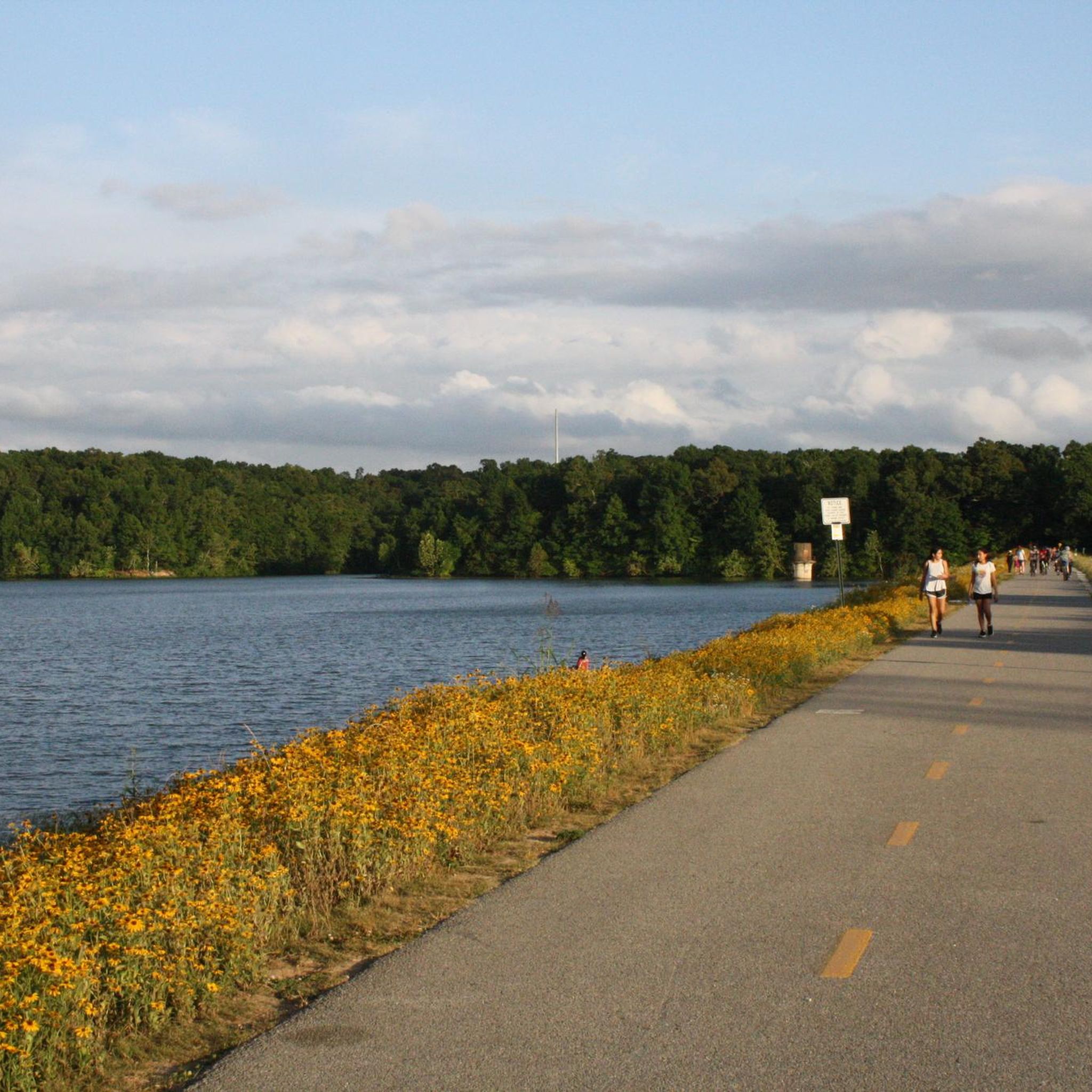
The Lake Fayetteville Loop offers a delightful escape into nature, encircling the tranquil 194-acre Lake Fayetteville with diverse scenery. You can choose between a smooth, paved multi-use path or a more rugged natural-surface trail that winds through towering hardwoods, evergreen thickets, and open grassy meadows. Expect picturesque lake views, vibrant wildflowers in spring and summer, and opportunities to spot waterfowl, deer, and squirrels along this moderate 5.6-mile (9.0 km) route with a gentle 177 feet (54 metres) of elevation gain. It’s a fantastic way to experience the natural beauty of Northwest Arkansas.

This accessible trail is well-equipped for visitors, featuring restrooms, picnic areas, and benches at various points, making it easy to take a break. The Lake Fayetteville Marina, roughly halfway around the loop, is a perfect spot to enjoy the water, and you can even consider a side trip to the Botanical Garden of the Ozarks. With an estimated duration of 2 hours and 19 minutes, it’s an ideal outing for a morning or afternoon, and the varied terrain ensures there’s something for every preference.

Beyond its recreational appeal, the Lake Fayetteville Loop is notable for its rich biodiversity and historical significance, having been created in the 1940s for flood control and as a city water source. The bridge spanning the Lake Fayetteville spillway is a popular photo spot, and a food truck court near the softball complex offers convenient dining options after your hike. It’s a popular recreational hub that beautifully blends natural features with community amenities, making it a true gem in Fayetteville.

Navigate with device

Send to Phone

Save

Moderate

5.0

(1)

6

hikers

15.8km

04:24

320m

280m

The Mount Kessler Loop offers a genuine taste of Ozark ruggedness, right within Fayetteville. This moderate hiking trail winds through old-growth forests and past unique geological formations like "Rock City," providing a journey through varied terrain. You'll navigate rocky singletrack and root-filled paths, with the reward of expansive views of the Fayetteville skyline from higher elevations. It's a great choice for hikers who appreciate a challenging natural environment.

Planning your visit is straightforward, with parking and restrooms available at Kessler Mountain Regional Park, the primary trailhead. Given the trail's 9.8 miles (15.8 km) distance and 1042 feet (317 metres) of elevation gain, plan for a solid 4 hours and 24 minutes of hiking. Be sure to wear appropriate footwear, as sections can become muddy during wet periods. Autumn is particularly stunning for the fall foliage, but the trail offers scenic views year-round.

Mount Kessler is a significant 1,500-acre urban forest, making it a crucial natural space within city limits. Beyond its natural beauty, the trail system holds historical remnants, including a 19th-century winery's stone cellar. This multi-use trail is popular not just with hikers, but also trail runners and birdwatchers, offering a diverse outdoor experience close to home.

Moderate
guide_signup
Let us show you the way with the komoot mobile app
With a free komoot account, you can easily find, customize, and navigate endless outdoor adventures.

Sign up for free

5.0

(1)

5

hikers

1.69km

00:27

20m

10m

The Wilson Park Trail Loop offers a pleasant urban park experience, winding through green spaces and past typical park amenities. This easy 1.0-mile (1.7 km) loop, with just 59 feet (18 metres) of elevation gain, can be completed in about 26 minutes, making it a perfect choice for a quick, refreshing walk. While mostly flat, you'll encounter a 'decent hill' on the south side, adding a subtle change in terrain. It's an ideal route for anyone seeking an accessible outdoor stroll within the city.

Planning your visit is simple, as the trail is known for its ease of access and convenient looped configuration. You'll find ample parking within Charles H. Wilson Park, making it easy to start your walk whenever suits you. This trail is a great option for a spontaneous outing, offering a dose of nature without requiring extensive planning or travel.

This trail stands out as a highly accessible and family-friendly option within an urban environment. Its gentle nature makes it suitable for a wide range of users, from those with young children to individuals looking for a light exercise. It provides a valuable green space for recreation and relaxation, proving that you don't always need to leave the city to enjoy a pleasant walk.

Easy

5.0

(1)

3

hikers

The Mount Kessler and Crazy Mary Trail Loop offers a rugged adventure through Fayetteville's Ozark landscapes, perfect for hikers who enjoy a challenge. You'll navigate rocky singletrack, technical rock gardens, and bluffs, with the Crazy Mary Trail itself presenting a notably rocky climb or descent. Keep an eye out for areas like "Rock City" and enjoy the diverse scenery, from dense hardwoods to unique moss-covered slab rock that feels like another world.

Starting from Kessler Mountain Regional Park, this multi-use trail system means you'll share paths with mountain bikers, so stay aware of your surroundings. Good hiking shoes or boots are essential for tackling the rocky and potentially muddy sections. While the trail intersections are well-marked, don't rely on blazes; a map is always a good idea. Visiting in the fall is particularly rewarding for views of the Boston Mountains.

Mount Kessler is a significant natural area within Fayetteville, encompassing 1,500 acres of preserved urban forest and serving as "Mile Zero" of the Razorback Greenway. This 5.2-mile (8.4 km) hike, with its 591 feet (180 metres) of elevation gain, is rated moderate and takes about 2 hours and 20 minutes. It provides a unique blend of demanding terrain and beautiful scenery, making it a standout option for those seeking advanced hiking routes in the region.

Moderate

5.99km

01:32

30m

20m

If you're looking for a genuinely easy and accessible outdoor experience in Fayetteville, the Mud Creek Trail delivers. This 3.7-mile (6.0 km) asphalt path follows the tranquil Mud Creek, offering a peaceful natural corridor even as it winds through commercial districts. With only 94 feet (29 metres) of elevation gain, it's a super flat route that you can comfortably complete in about 1 hour and 32 minutes, making it ideal for a relaxed walk or a family outing.

Planning your visit to this easy trail is straightforward. As part of the larger Razorback Greenway, you'll find multiple access points, and parking is generally convenient in the surrounding Fayetteville area. The paved surface means it's suitable for year-round use, though a clear, mild day will always enhance the experience. You won't need any special permits or gear for this urban greenway.

What makes this Mud Creek Trail particularly notable is its integration into the extensive Razorback Greenway network, allowing you to extend your adventure far beyond its 3.7 miles if you wish. It's a multi-use path, perfect for walking, jogging, or cycling, and its flat terrain and natural setting provide a welcome escape within the city, especially for families with young children or those seeking a gentle, accessible route.

Easy
Sign up for free to see 25 more hikes around Fayetteville.

Get access to more routes and recommendations from other explorers.

Sign up for free

Already have an account?

Our route recommendations are based on thousands of hikes, rides, and runs completed by other people on komoot.

Start today with a free account

Your next adventure awaits.

Login or Signup

Popular around Fayetteville

MTB Trails around Fayetteville

Road Cycling Routes around Fayetteville

Cycling around Fayetteville

Running Trails around Fayetteville

Gravel biking around Fayetteville

Tips from the Community

oliviakellis
May 21, 2025, Kessler Mountain Regional Park

Kessler Mountain Regional Park, situated in southwest Fayetteville, Arkansas, spans over 620 acres and offers a diverse range of recreational activities. The park features six lighted soccer fields, eight lighted baseball fields, and a large playground near the entrance. For nature enthusiasts, there are more than 10 miles of natural-surface trails suitable for hiking and mountain biking, catering to various skill levels. The park also encompasses a nearly 400-acre nature preserve, showcasing the region's native flora and fauna. With its combination of athletic facilities and natural landscapes, Kessler Mountain Regional Park serves as a hub for both sports and outdoor exploration in Fayetteville.

0

0

This 620-acre park features over ten miles of trails of different levels, where you'll encounter other cyclists as well as hikers, so you need to pay attention. You can access the trails from the playground area or from the parking lot near the baseball fields in the northern area.

2

0

LadyDi
September 18, 2022, Clear Creek

Make a stop on the Clear Creek bridge and admire the beauty of the rocky streambed. By the way, the multi-use trail Razorback Regional Greenway is also called Clear Creek Trail from here on and follows the course of the creek for a few miles.

2

0

This beautiful multi-use path lead is part of the Northwest Arkansas Razorback Regional Greenway that is altogether almost 38 miles long and takes you to spectacular places like the Lake Fayetteville.

4

0

Frequently Asked Questions

How many hiking trails are available around Fayetteville?

Fayetteville offers a network of 19 hiking trails. These routes cater to various preferences, with 13 classified as easy and 6 as moderate, ensuring options for different skill levels.

What is the general difficulty level of hiking trails in Fayetteville?

The hiking trails around Fayetteville are predominantly easy to moderate. You'll find 13 easy routes, perfect for a relaxed stroll, and 6 moderate trails for those seeking a bit more challenge. There are no difficult trails listed in this guide.

Are there any loop trails for hiking in Fayetteville?

Yes, many trails in Fayetteville are designed as loops, offering a convenient way to explore without retracing your steps. Examples include the Mount Kessler & Crazy Mary Trail loop and the Mount Sequoyah Woods loop.

What are some good options for family-friendly hikes in Fayetteville?

For families, easy and shorter loop trails are ideal. The Lake Sequoyah Shoreline Trail loop is an easy 2.5-mile path that offers pleasant views and is suitable for most ages. The Mount Sequoyah Woods loop is another easy option, just under 3 miles, through mature woodlands.

Are dogs allowed on the hiking trails in Fayetteville?

While specific regulations can vary by park or trail, many outdoor areas in Fayetteville, including trails like the Mount Kessler & Crazy Mary Trail loop, are generally dog-friendly. It's always best to keep your dog on a leash and check local park rules before you go.

What kind of scenery can I expect on Fayetteville's hiking trails?

Fayetteville's trails offer diverse scenery, from dense woodlands and rolling hills within the Ozark Mountains to tranquil lake shores. You'll find forested paths, such as the Mount Sequoyah Woods loop, and routes that follow greenways, like parts of the Razorback Greenway Trail.

Are there any trails with scenic views in Fayetteville?

Many trails offer scenic views, particularly those that ascend local peaks or follow waterways. The Mount Kessler & Crazy Mary Trail loop provides views from the forested slopes of Kessler Mountain, while the Lake Sequoyah Shoreline Trail loop offers pleasant lakeside vistas.

What do other hikers enjoy most about hiking in Fayetteville?

The hiking experience in Fayetteville is highly rated by the komoot community, with an average score of 5.0 stars. Hikers often praise the well-maintained paths, the peaceful forested environments, and the accessibility of trails for various skill levels.

Are there any nearby attractions or points of interest accessible from the hiking trails?

Yes, several attractions are close to the hiking areas. You can explore Lake Wedington Recreation Area, which offers additional outdoor activities, or visit Centennial Park at Millsap Mountain, known for its mountain biking facilities but also featuring trails. Coyote Cave Trail is another point of interest for exploration.

How long do the hiking trails in Fayetteville typically take to complete?

The duration of hikes varies depending on the trail and your pace. For example, the easy Mount Kessler & Crazy Mary Trail loop (4.4 miles) takes about 2 hours, while the moderate Razorback Greenway Trail – Clear Creek loop (5.5 miles) can take around 2 hours and 15 minutes.

Are there any paved or accessible sections on Fayetteville's trails?

Yes, some trails incorporate paved sections, particularly those that are part of the broader greenway system. The Razorback Greenway Trail – Clear Creek loop, for instance, offers a mix of paved and natural surfaces, which can provide more accessible options for some users.

Where can I find parking for hiking trails in Fayetteville?

Most major parks and trailheads in Fayetteville, such as Kessler Mountain Regional Park, Mount Sequoyah Park, and Lake Sequoyah Park, offer designated parking areas for hikers. It's advisable to check the specific park's website or komoot tour details for precise parking information before your visit.

Most popular routes around Fayetteville

Easy hikes around Fayetteville

Most popular attractions around Fayetteville

Places to see

Store rating

Get inspired with the komoot mobile app

With a free komoot account, you can easily find, customize, and navigate endless outdoor adventures.

or

Join komoot Now

Store rating

Explore more

Browse the best Hikes in other regions.

FarmingtonTontitownElm SpringsGreenlandPrairie GroveSpringdaleJohnsonGoshenWest ForkElkins

Nearby adventure guides

Things to Do around Johnson

background

Get ready to conquer new peaks

Sign up for Free

Explore
RoutesRoute plannerFeaturesHikesMTB TrailsRoad cycling routesBikepackingSitemap
Download the app
Follow Us on Socials

© komoot GmbH

Privacy Policy