The best mountain hikes around Marckolsheim
5.0
(3)
11
hikers
3
hikes
Mountaineering routes around Marckolsheim primarily explore the diverse landscapes of the Grand Ried region and the nearby Kaiserstuhl hills. While Marckolsheim itself is characterized by the flat, watery terrain of the Rhenish Forest and its numerous waterways, the surrounding area offers varied elevations. The region provides access to the volcanic hills of Kaiserstuhl, featuring vineyards and forested slopes suitable for mountain hiking.
Best mountaineering routes around Marckolsheim
- The most popular mountaineering route is Texas Pass (Texaspass) – Weinlauben Street in…
Last updated: June 26, 2026
4
hikers
Moderate mountaineering route. Good fitness required. Easily-accessible paths. Suitable for all skill levels.
4
hikers
Moderate mountaineering route. Good fitness required. Easily-accessible paths. Suitable for all skill levels.

Sign up for free
5.0
(1)
1
hikers
7.99km
02:29
310m
310m
Moderate mountaineering route. Good fitness required. Easily-accessible paths. Suitable for all skill levels.
5.0
(1)
1
hikers
17.9km
05:23
560m
560m
Hard mountaineering route. Very good fitness required. Mostly accessible paths. Sure-footedness required.
5.0
(1)
1
hikers
Hard mountaineering route. Very good fitness required. Easily-accessible paths. Suitable for all skill levels.
Our route recommendations are based on thousands of hikes, rides, and runs completed by other people on komoot.
Start today with a free account
Your next adventure awaits.
Login or Signup
Tips from the Community

A very beautiful path through the forest up the Totenkopf to the Neulindenturm. The steep and somewhat rocky climb is much more enjoyable than the wide path from the south, which I then continued on.
1
0

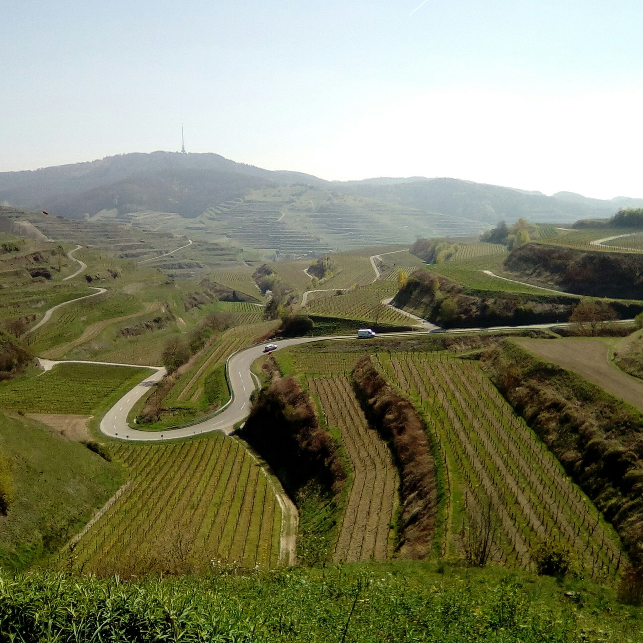
The Texas Pass connects the two towns of Oberbergen and Kiechlinsbergen in the Kaiserstuhl region. The connecting road was named Texas Pass because of its distinctive switchbacks.
0
0

just stop and enjoy
1
0

Highest point point around, worth the visit for the view!
0
0
Highest point of the Kaiserstuhl offering great views, and a perfect road to enjoy a decline on either bike.
0
0

Beautiful view, a life-affirming totem, a lounger, a bench, a table and a great view of the Kaiserstuhl and towards Freiburg.
1
0

On the way from Mondhalde to Katharinenberg you cross the road at Texaspass, also known for the cycling races that cross the ridge here.
0
0

Beautiful views over the slopes of the Kaiserstuhl. The sign explains what you can see
3
0
Frequently Asked Questions
How many mountaineering routes are available around Marckolsheim?
There are several mountaineering routes around Marckolsheim listed on komoot, primarily exploring the Kaiserstuhl hills. These include options like the Texas Pass (Texaspass) – Weinlauben Street in Oberbergen loop from Kaiserstuhl, offering diverse experiences through vineyards and forested landscapes.
Are there easy mountaineering routes suitable for beginners near Marckolsheim?
While there are no routes specifically classified as 'easy' in this selection, many of the routes are rated 'moderate' and are suitable for those with a reasonable fitness level. For instance, the Texas Pass (Texaspass) – Weinlauben Street in Oberbergen loop from Oberrotweil is a moderate path featuring scenic views.
What about more challenging mountaineering routes?
For those seeking a greater challenge, routes like the Neunlinden Tower – Totenkopf Observation Tower loop from Ohrberg are classified as 'difficult'. These routes typically involve longer distances and more significant elevation gains, providing a rewarding experience for experienced mountaineers.
Are there any circular mountaineering routes in the area?
Yes, many of the mountaineering routes around Marckolsheim are designed as circular loops, allowing you to start and end at the same point. Examples include the Vogelsang Pass Viewpoint – Neunlinden Tower loop from Kaiserstuhl, which takes you through forested hills and past viewpoints.
What kind of scenery can I expect on these mountaineering routes?
The mountaineering routes primarily explore the volcanic Kaiserstuhl hills, offering a unique blend of vineyard-clad slopes, dense forests, and panoramic viewpoints across the Rhine plain and towards the Vosges Mountains. You'll encounter diverse flora and fauna characteristic of this fertile region.
Are there any family-friendly mountaineering options?
While the listed mountaineering routes are generally moderate to difficult, the broader Grand Ried region around Marckolsheim offers numerous accessible nature trails and parks suitable for families. These include trails within the Rhenish Forest and local parks with playgrounds, perfect for a less strenuous outdoor experience.
Can I bring my dog on the mountaineering routes near Marckolsheim?
Generally, dogs are welcome on trails in the Kaiserstuhl and Vosges regions, but it's always advisable to keep them on a leash, especially in nature reserves, near livestock, or during nesting seasons. Always check local signage for specific restrictions on individual routes.
What are some interesting sights or landmarks along the mountaineering routes?
Along the routes, especially in the Kaiserstuhl area, you can enjoy panoramic views from points like the Neunlindenturm on the Totenkopf. The region also features unique geological formations such as loess hollow ways, like the Eichgasse Loess Hollow Way. Additionally, you might encounter historical sites like the Sponeck Castle nearby.
Is public transport available to access the mountaineering trails?
Access to the Kaiserstuhl region, where many of these mountaineering routes are located, is generally possible via regional train and bus services. However, specific trailheads might require a short walk from the nearest public transport stop. It's recommended to check local transport schedules in advance.
Are there parking facilities at the trailheads?
Yes, most popular trailheads in the Kaiserstuhl region, including those for the listed mountaineering routes, offer designated parking areas. These are often found near villages or key access points, making it convenient for those traveling by car.
What is the best time of year for mountaineering around Marckolsheim?
The best time for mountaineering around Marckolsheim and the Kaiserstuhl is typically from spring to autumn (April to October). During these months, the weather is generally mild, and the vineyards and forests are at their most vibrant. Winter can offer a different experience, but some trails might be slippery or less accessible due to snow or ice.
What do other mountaineers say about the routes in this area?
The mountaineering routes around Marckolsheim are highly rated by the komoot community, with an average score of 5.0 stars from over 3 reviews. Mountaineers often praise the scenic views, the unique vineyard landscapes, and the well-maintained paths that offer a rewarding outdoor experience.
Where can I find information about the unique Rhenish Forest?
The Rhenish Forest (Forêt du Rhin), a significant natural heritage site near Marckolsheim, is a wetland forest known for its rich biodiversity. You can find more information about this 'Rhineland jungle' and its marked trails for walking and cycling on the Visit Alsace website.
Most popular routes around Marckolsheim
Most popular attractions around Marckolsheim

Get inspired with the komoot mobile app


