The best road cycling routes around Springfield
5.0
(6)
99
riders
5
rides
Road cycling routes around Springfield offer a diverse landscape for cyclists. The region features a mix of greenway trails, multi-use paths, and on-street routes, often winding through natural settings. Terrain includes rolling hills, woodlands, and routes alongside creeks and rivers. The area provides options for various skill levels, from easy paved paths to moderate routes with gentle elevation changes.
Best road cycling routes around Springfield
- The most popular road cycling route is Xenia Station – Glen Helen Nature Preserve loop…
Last updated: June 29, 2026
5.0
(3)
40
riders
51.0km
02:29
170m
170m
Moderate road ride. Good fitness required. Mostly well-paved surfaces and easy to ride.
18
riders
38.6km
02:16
140m
140m
Moderate road ride. Good fitness required. Some segments of this route may be unpaved and difficult to ride.

Sign up for free
11
riders
22.4km
01:13
80m
80m
Easy road ride. Great for any fitness level. Mostly well-paved surfaces and easy to ride.
6
riders
51.6km
02:55
210m
210m
Moderate road ride. Good fitness required. Mostly well-paved surfaces and easy to ride.
5.0
(2)
5
riders
Easy road ride. Great for any fitness level. Mostly well-paved surfaces and easy to ride.
Our route recommendations are based on thousands of hikes, rides, and runs completed by other people on komoot.
Start today with a free account
Your next adventure awaits.
Login or Signup
Popular around Springfield

Other adventures around Springfield

Tips from the Community

This 700-acre preserve was created from a gift of land to Antioch College by Hugh Taylor Birch to honor his daughter, Helen Birch Bartlett. Much of it is along the two creeks that flow by, and the trails access a number of picturesque waterfalls.
0
0

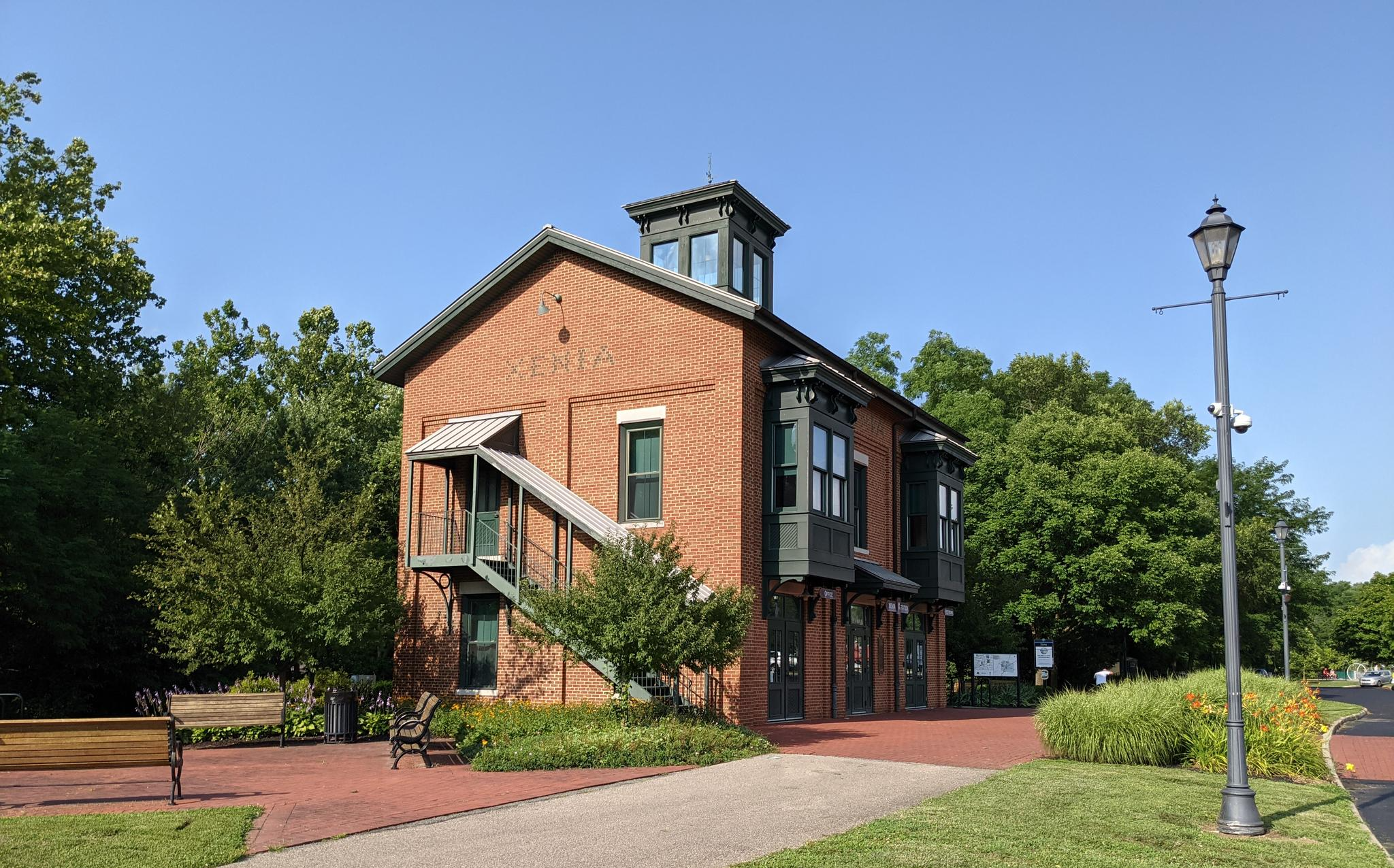
The Xenia Station is a replica of an old brick train station that used to be in the area. It now holds a museum and meeting space, and serves as a trail head for several trails that intersect at this point.
1
0
This 700-acre preserve was created from a gift of land to Antioch College by Hugh Taylor Birch to honor is daughter Helen Birch Bartlett. Much of it is along the two creeks that flow by and the trails access a number of picturesque waterfalls.
1
0
The Little Miami Scenic Trail is the 4th longest paved trail in the US, and the longest trail within the Miami Valley. It runs for just over 78 miles and gives bikers, runners, and walkers to many cities, towns, state parks, and other trails that branch off or intersect it.
0
0

Xenia Station, located at 150 Miami Avenue in Xenia, Ohio, in the United States, is a replica of Xenia's 1880s brick railroad station. Built in 1998 by the city of Xenia, Xenia Station houses a local history museum, a classroom/meeting space and an observation tower called the Hub Lookout.
2
0

Great spot to regroup, bathrooms open (during Covid) always cyclist around.
0
0
Frequently Asked Questions
What types of road cycling routes are available in Springfield?
Springfield offers a diverse range of road cycling routes, including dedicated greenway trails, multi-use paths, and scenic on-street routes. You can find everything from easy paved paths to moderate routes with gentle elevation changes, catering to various skill levels. The region features routes winding through natural settings, alongside creeks and rivers, and through parklands.
How many road cycling routes are detailed in this guide for Springfield?
This guide features 6 road cycling routes around Springfield. These include 2 easy routes and 4 moderate routes, ensuring options for different preferences and fitness levels.
What kind of terrain can I expect on road cycling routes around Springfield?
The terrain varies across Springfield. In Springfield, Missouri, routes often feature rolling hills and woodlands typical of the Ozarks region. In Springfield, Illinois, you'll find flatter sections along former railway lines like the Interurban Trail, but also some routes with more significant elevation changes, such as the Lost Bridge Trail or the 'Mount Doom' section of the Interurban Trail.
Are there any easy road cycling routes suitable for beginners in Springfield?
Yes, Springfield offers easy road cycling routes perfect for beginners. For example, the Roadbike loop from Buck Creek State Park is an easy 14.0-mile (22.5 km) trail that leads through parklands and alongside water features. Another easy option is the Little Miami Scenic Trail – Glen Helen Nature Preserve loop from Beatty, which covers 20.4 km with minimal elevation gain.
What are some scenic highlights or natural features I might encounter on a road cycling route?
Road cycling routes in Springfield offer various scenic highlights. In Springfield, Missouri, you can enjoy views of the James River Bridge along the Galloway Creek Greenway, or explore the historical sites and shaded areas along Wilson's Creek. In Springfield, Illinois, routes like the Interurban Trail cross Lake Springfield, providing beautiful water views, while the Lost Bridge Trail follows an abandoned railroad bed across several creeks, often providing shade.
Are there any routes that combine cycling with historical sites?
Yes, in Springfield, Missouri, the Wilson's Creek National Battlefield Loop offers a unique combination of natural beauty and historical significance. Cyclists can ride a paved, bicycle-friendly road within the battlefield, which highlights key historical points, making for an engaging ride.
What do other road cyclists enjoy most about road cycling in Springfield?
The road cycling routes in Springfield are highly rated by the komoot community, with an average score of 5.0 stars from over 7 reviews. Cyclists often praise the diverse terrain, the well-maintained greenway trails, and the scenic beauty of the region, from rolling hills to river views.
Are there any routes that pass by lakes or significant water bodies?
Absolutely. In Springfield, Missouri, some routes head north towards Fellows Lake and Valley Water Mill Pond. In Springfield, Illinois, the Interurban Trail crosses Lake Springfield, offering picturesque water views, and the Lost Bridge Trail crosses several creeks.
Can I find longer, more challenging road cycling routes in Springfield?
While this guide features moderate routes, the broader Springfield region, particularly the Ozarks topography in Missouri and the Sangamon River Valley in Illinois, offers options with more significant elevation changes for advanced cyclists. Routes like the Xenia Station – Glen Helen Nature Preserve loop from Beatty and the Little Miami Scenic Trail loop from Clark State Community College are moderate and cover distances over 50 km, providing a good challenge.
Are there any loop routes available for road cycling in Springfield?
Many of the road cycling routes in Springfield are designed as loops for convenience. Examples include the Little Miami Scenic Trail loop from Wittenberg University, the Roadbike loop from Buck Creek State Park, and the Xenia Station – Glen Helen Nature Preserve loop from Beatty, all offering circular paths.
What are the typical distances for road cycling routes in Springfield?
The road cycling routes in this guide for Springfield vary in distance. You can find shorter routes like the Roadbike loop from Buck Creek State Park at 22.5 km (14.0 miles), up to longer moderate routes such as the Xenia Station – Glen Helen Nature Preserve loop from Beatty, which is 51.0 km (31.7 miles) long.
Most popular routes around Springfield

Get inspired with the komoot mobile app


Explore more
Browse the best Road cycling routes in other regions.
