The best gravel rides in Holmes County
4.5
(2)
85
riders
9
rides
Gravel biking in Holmes County, Ohio, is characterized by its diverse terrain, ranging from rolling hills and extensive farmlands to dense woodlands. The region features a mix of paved surfaces and country roads with challenging, loose gravel sections. This landscape is shaped by its position at the edge of the Appalachian foothills, offering varied elevation changes and scenic vistas. The Killbuck Marsh Wildlife Area also contributes wetlands and natural features to the area's topography.
Best gravel bike trails in Holmes County
- The most popular gravel bike trail is Covered Bridge – Bridge of Dreams loop from Mohican Memorial State Forest, a 68.0 miles (109.5 km) trail that takes 9 hours 51 minutes to complete. This route features covered bridges and passes through the scenic Mohican Memorial State Forest.
- Another top favourite among local gravel bikers is Holmes County Trail – Baddow Pass History Signage loop from Glenmont, a difficult 60.2 miles (96.8 km) path. This route incorporates sections of the Holmes County Trail, offering views of farmland and historical signage.
- Local gravel bikers also love the Baddow Pass History Signage loop from Glenmont, a 64.3 miles (103.4 km) trail leading through rolling hills and rural landscapes, often completed in about 9 hours 15 minutes.
- Gravel biking in Holmes County is defined by rolling hills, farmlands, and woodlands, with varied road surfaces including paved sections and challenging gravel. The network offers options for experienced gravel cyclists seeking significant elevation gain.
- The routes in Holmes County are highly rated by the komoot community with an average score of 4.5 stars from a few reviews. More than 70 gravel bikers have used komoot to explore Holmes County's varied terrain.
Last updated: June 28, 2026
26
riders
109km
07:26
1,650m
1,650m
The Covered Bridge – Bridge of Dreams loop from Mohican Memorial State Forest offers a truly diverse gravel biking experience, blending rolling gravel roads with paved sections through the scenic Mohican River Valley. You'll navigate shaded woodlands, open farmlands, and pass through Amish country, all while tackling a difficult 68.0-mile (109.5 km) route with a substantial 5422 feet (1653 metres) of elevation gain. The iconic Bridge of Dreams serves as a memorable centerpiece, making this a challenging yet rewarding ride for those seeking a full day on the bike.
Planning your ride requires attention to detail, as this route can take around 7 hours and 26 minutes, or even longer depending on your pace and conditions. Be ready for varied terrain, including potentially muddy spots and large puddles after rain, and be mindful of shared sections with Amish buggies and horses. This is not a beginner route; its difficulty rating means you should have very good fitness and be comfortable with steep, slick gravel climbs.
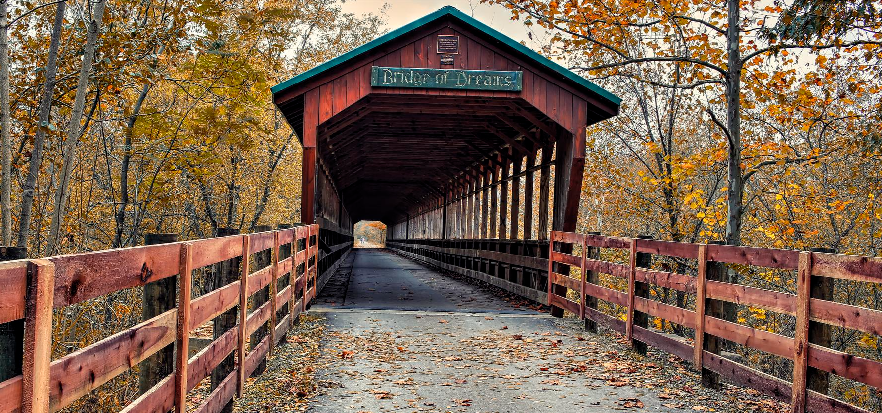
What makes this loop stand out is the historic Bridge of Dreams itself, a 370-foot covered bridge that was once a railroad bridge and is now the second-longest covered bridge in Ohio. It's a unique multi-use path, shared respectfully by cyclists, hikers, and the local Amish community. This route also forms a part of the larger Ohio to Erie Trail network, offering a glimpse into a significant regional trail system.
13
riders
44.3km
03:20
820m
820m
The Climb loop from Mohican Wilderness Campground offers a deep dive into the scenic Mohican Wilderness, where you'll navigate rolling gravel roads and hard-packed decomposed granite surfaces. This route is defined by its sustained climbs, taking you through extensive forests and river valleys, with glimpses of picturesque features like covered bridges. It's a demanding ride that rewards you with a true sense of accomplishment and immersion in nature.
Planning your ride means preparing for a difficult 27.5-mile (44.3 km) journey with 2696 feet (822 metres) of elevation gain, typically taking around 3 hours and 19 minutes. The trailhead is conveniently located at Mohican Wilderness Campground, a popular spot. Arriving early is advisable, especially on busy days, to ensure a smooth start to your adventure.
This loop is a standout for advanced gravel bikers in Ashland County, known for its emphasis on challenging ascents. The Mohican region itself is a hub for outdoor enthusiasts, boasting diverse terrain and stunning vistas, including the Clear Fork Gorge and Lyon's Falls nearby. It's a prime destination for those seeking a rigorous workout within a beautiful natural setting.

Sign up for free
9
riders
103km
06:25
1,620m
1,610m
Hard gravel ride. Very good fitness required. Mostly paved surfaces. Suitable for all skill levels.
6
riders
99.2km
06:09
1,410m
1,410m
Hard gravel ride. Very good fitness required. Mostly paved surfaces. Suitable for all skill levels.
8
riders
38.5km
02:42
560m
560m
The Baddow Pass History Signage loop from Mohican Wilderness Campground offers a demanding gravel biking experience through Ohio's scenic Ashland County. You'll navigate diverse landscapes, from dense forests to wide river valleys, with sections of the Mohican Valley Trail showcasing quiet hills and historical markers. Expect a mix of paved and unpaved surfaces, including challenging stretches of chunky gravel and steep climbs that might require you to push your bike. Keep an eye out for the impressive Bridge of Dreams, a notable landmark along the route.
This difficult 23.9-mile (38.5 km) loop features 1847 feet (563 metres) of elevation gain and typically takes around 2 hours and 42 minutes to complete. Starting from the Mohican Wilderness Campground provides convenient access to the trailhead. Given the significant elevation changes and varied terrain, ensure you have very good fitness and carry ample water, especially during warmer months. Dry conditions are ideal for tackling this advanced gravel biking route.
Beyond the physical challenge, this route is rich in history, with signage along the trail detailing its past as a Pennsylvania Railroad line. It's part of the larger Ohio to Erie Trail, blending a connection to the region's heritage with a robust workout. The Mohican Wilderness area is known for its outdoor activities, making this loop a prime example of the challenging gravel biking trails available.
4.5
(2)
7
riders
45.7km
03:03
640m
640m
The Climb loop from Camp Check-In is a demanding gravel biking route that plunges you into dense forests and offers the promise of expansive mountain vistas. You'll navigate a mix of surfaces, from smooth packed dirt to loose gravel and even some rutted sections, with former railroad beds providing a unique historical element to parts of the journey. This difficult 28.4-mile (45.7 km) loop, with its 2094 feet (638 metres) of elevation gain, is a true test of endurance, typically requiring around 3 hours and 2 minutes to complete.
To tackle this challenging route, make sure your bike is equipped with high-volume tires, ideally run at lower pressure for better traction and comfort on varied terrain. Given the significant climbing involved, appropriate gearing is essential. As this type of gravel loop often ventures into remote areas, plan for self-sufficiency by carrying plenty of water, food, and repair essentials.
Beyond the physical challenge, this climb loop offers a genuine sense of adventure, leading you through quiet forest roads where stunning views from high elevations are a recurring highlight. It's an excellent route to test your fitness and enjoy the solitude of nature, making it a favorite for those preparing for races or simply seeking a rigorous outdoor experience.
3
riders
Hard gravel ride. Very good fitness required. Mostly paved surfaces. Suitable for all skill levels.
4
riders
52.8km
03:36
690m
690m
Hard gravel ride. Very good fitness required. Mostly paved surfaces. Suitable for all skill levels.
Our route recommendations are based on thousands of hikes, rides, and runs completed by other people on komoot.
Start today with a free account
Your next adventure awaits.
Login or Signup





Other adventures in Holmes County

Tips from the Community

This small display has a short write up and a few pictures going over the history and importance of Baddow Pass.
0
0
This 370-foot covered bridge began as a railroad bridge in the 1920s. It wasn't covered until 1998, at which point it became the second longest covered bridge in Ohio, and the third longest in the USA.
1
0


The Holmes County Trail is a 23-mile paved trail that travels through Ohio's Amish country. This path was the first path in the country designed to accommodate Amish buggies.
0
0

Beautiful covered bridge built in 1969 as a tribute to the other covered bridges in Ohio. This bridge is open to car and pedestrian traffic.
0
0

Primitive Camping for Cyclists. Picnic Table, Fire ring, grass field.
1
0
Frequently Asked Questions
What kind of terrain can I expect on gravel bike trails in Holmes County?
Holmes County offers a diverse range of terrain for gravel biking. You'll encounter rolling hills, extensive farmlands, and woodlands. The road surfaces vary from paved sections, particularly on the Holmes County Trail, to challenging country roads with steep and loose gravel sections. This mix provides options for both leisurely rides and more demanding adventures.
Are there any easy gravel bike trails suitable for beginners or families?
While many of the dedicated gravel routes in Holmes County are rated as difficult, the Holmes County Trail offers a fantastic, family-friendly option. This 29-mile paved trail, built on an old railroad bed, is flat and smooth, making it accessible for all skill levels. It's a great way to experience the scenic countryside and even share the path with Amish buggies.
What natural features or landmarks can I see while gravel biking in Holmes County?
You'll be treated to picturesque views of rolling hills, open farmlands, and dense woodlands. The region is home to the Killbuck Marsh Wildlife Area, where you might spot diverse wildlife like sandhill cranes and bald eagles. Some routes, such as the Covered Bridge – Bridge of Dreams loop from Mohican Memorial State Forest, also feature charming covered bridges and pass through the scenic Mohican Memorial State Forest.
Are there challenging routes for experienced gravel bikers in Holmes County?
Absolutely. Holmes County is known for its challenging gravel routes, often featuring significant elevation gain and varied surfaces. Routes like the Climb loop from Mohican Wilderness Campground offer substantial climbs and rewarding descents, appealing to those looking for a rigorous gravel biking experience.
What unique cultural experiences can I have while biking in Holmes County?
A truly unique aspect of biking here is sharing the path with the Amish community. The Holmes County Trail is specifically designed to accommodate both cyclists and Amish buggies, offering a peaceful and immersive cultural experience as you ride alongside horse-drawn vehicles through the scenic countryside.
What do other gravel bikers enjoy most about gravel biking in Holmes County?
The area is highly rated by the komoot community, with an average score of 4.5 stars. Reviewers often praise the diverse terrain, the scenic beauty of the rolling hills and farmlands, and the unique cultural experience of sharing trails with Amish buggies. The challenging nature of many routes is also a highlight for experienced riders.
Are there loop routes available for gravel biking in Holmes County?
Yes, many of the gravel biking routes in Holmes County are designed as loops, allowing you to start and end at the same point. Examples include the Covered Bridge – Bridge of Dreams loop from Mohican Memorial State Forest and the Baddow Pass History Signage loop from Glenmont, which take you through varied landscapes.
What is the best time of year to go gravel biking in Holmes County?
Spring and fall generally offer the most pleasant conditions for gravel biking in Holmes County, with milder temperatures and beautiful scenery as the landscape changes. Summer can be enjoyable, but be prepared for warmer weather. Always check local weather forecasts before heading out.
Where can I find more information about outdoor activities and recreation in Amish Country?
For additional details on outdoor adventures and recreation opportunities in the wider Amish Country region, you can visit the official tourism website. Check out visitamishcountry.com/outdoors-adventuring or visitamishcountry.com/adventures/recreation-nature for more context.
How many gravel bike trails are available in Holmes County?
There are at least 9 distinct gravel bike trails documented in Holmes County, offering a range of experiences for riders. All of these are currently rated as difficult, providing ample challenge for experienced gravel cyclists.
Can I expect significant elevation gain on gravel bike routes in Holmes County?
Yes, many gravel bike routes in Holmes County feature significant elevation gain due to the region's rolling hills and position at the edge of the Appalachian foothills. For example, the Holmes County Trail – Baddow Pass History Signage loop from Glenmont includes over 1300 meters of ascent, making for a demanding ride.
Most popular routes in Holmes County

Get inspired with the komoot mobile app


Didn’t find what you were looking for?
Check out more Gravel rides throughout Holmes County below and find the perfect route in your destination.
Explore more
Browse the best Gravel rides in other regions.
