Attractions and Places To See in Reserva Ecológica Los Ilinizas - Top 7
Best attractions and places to see in Reserva Ecológica Los Ilinizas, located in Ecuador, is a protected area spanning approximately 149,900 hectares across three provinces. This reserve features diverse ecosystems, from cloud forests to Andean páramos. Dominant features include the twin peaks of Cerro Los Ilinizas and the emerald-green Laguna Quilotoa. The region also holds cultural significance, with an 18-kilometer stretch of the ancient Qhapaq Ñan (Inca Trail) traversing the area.
Best attractions and places to see in Reserva Ecológica…
Last updated: July 5, 2026
Quilotoa Lagoon
Highlight • Lake
Tip by

Iliniza Norte Summit
Highlight • Summit
Tip by

Sign up now to discover places like this
Get recommendations on the best single tracks, peaks, & plenty of other exciting outdoor places.
Sign up for free
Corazón Summit
Highlight • Summit
Translated by Google •
Tip by

View of Quilotoa Lagoon
Highlight • Viewpoint
Translated by Google •
Tip by

Quilotoa Lagoon Viewpoint
Highlight • Viewpoint
Translated by Google •
Tip by

Sign up for free to discover even more attractions in Reserva Ecológica Los Ilinizas.
Sign up for free
Already have an account?
Start today with a free account
Your next adventure awaits.
Login or Signup
Popular around Reserva Ecológica Los Ilinizas

Other adventures in Reserva Ecológica Los Ilinizas

Tips from the Community

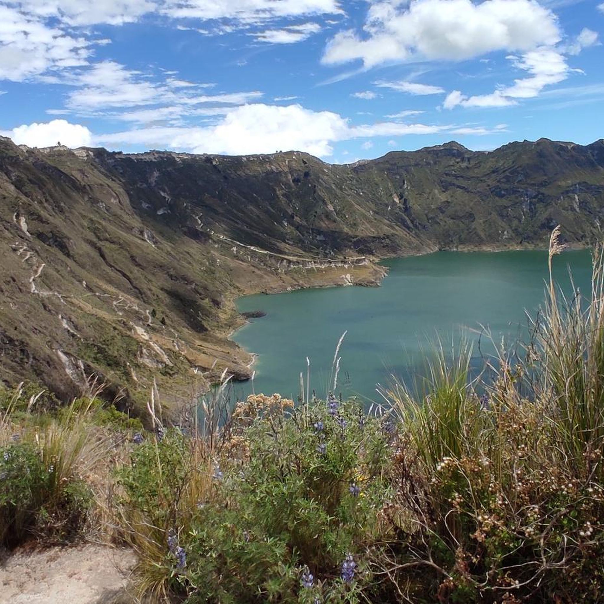
The lake is impressively colored in deep turquoise in its round bed. Jagged is the cliff edge that frames it, creating a path for the hiker to admire the beauty of the lagoon from all sides.
2
0
With luck and clear visibility, climbing this peak will reveal all the surrounding volcanoes. Antisana, Chimborazo, Iliniza Sur and Cotopaxi. The view into the vast depths is also wonderful.
0
0

Beautiful vantage point on the crater rim of Laguna Quilotoa.
1
0

Laguna Quilotoa, an incredibly beautiful place on earth! Easy to reach on foot from the parking lot. You can completely circumnavigate the lagoon on the loop. A sandy path also leads down to the lake (swimming prohibited), which you have to climb back up steeply. Those who like this (dubious) variant can also be carried up by donkey.
0
0

We went from El Chaupi to the Corazón. Our ascent began at the entrance to the Reserva, where we left the car. Then we followed the dirt road to the marked junction of the path to Corazón. From now on we went on muddy paths through the Paramo up to a ridge that led us directly to the summit. This path climbs very steeply in places. One point, a rather exposed rock transition, is a bit daring to cross, but almost everyone can master it with concentration and the use of hands. However, normal dogs have problems here. The point is about 30 minutes from the summit. After overcoming this passage, it goes on with easy scrambling to the summit. If several people are on the move, a helmet is a good idea because of the risk of stones being kicked. I have now been to the Corazón twice and unfortunately, despite the early start (ascent from 6:30 a.m.), the weather never allowed me a clear view of the summit. The photos of the Ilinizas, the Cotopaxi, Ruminahui, Sincholagua and even the Antisana were only possible at the beginning of the hike. The ascent to the summit took about 4 hours. We had taken a few breaks.
1
0
It took us 6.5 hours in total. The starting and ending point was "La Virgen". The route to the Refugio is clear and easy to do if you are fit. From the Refugio, after approx. 300 m, it goes into the rock, where a few tricky passages must be walked with caution. This last bit is also the reason why you officially need a guide for this tour.
2
0

This is an excellent peak to hike/climb. At 5,130m it is a worthy summit to tick off. It is quite easy and non technical. Quite feasible to do it with just ice axe and crampons. The views of Cotopaxi from the summit are superb. There is also a spartan unmanned hut on the col between Sur and Norte to make the summit day and easier one.
3
0

Quilotoa Lake is about 30 minutes from Latacunga and should not be missed on an Ecuador trip. The walk around the crater takes around 4-5 hours, depending on the breaks you take. For trained people, the circumnavigation is also possible in 3 - 3.5 hours. The highest point is at over 3900 meters. Right on the lake there is the possibility to rent a kayak for $ 3 (30 minutes) to admire the crater from below. Descent to the lake about 40 minutes, ascent about 1 hour. Make sure you wear good shoes. The views are amazing.
3
4
Frequently Asked Questions
What are the most prominent natural attractions in Reserva Ecológica Los Ilinizas?
The reserve is dominated by the twin peaks of Cerro Los Ilinizas, specifically Iliniza Norte Summit, which is popular for climbing. Another breathtaking natural feature is Quilotoa Lagoon, an emerald-green crater lake where you can hike or kayak. You can also find Corazón Summit, known for its heart-like shape and views of surrounding volcanoes.
Are there challenging climbs for experienced mountaineers in the reserve?
Yes, Iliniza Norte Summit (5,130m) offers a worthy climb, considered accessible yet challenging enough for those with some experience. For a more technical ascent, Iliniza South (5,263-5,265m) presents steep ice slopes and glaciers, suitable for experienced climbers with technical equipment and ice climbing skills. The Nuevo Horizontes Refuge serves as a base for climbers aiming for these peaks.
What are some easier hiking options for beginners or those seeking less technical routes?
For less technical routes, the hike around Quilotoa Lagoon is a popular choice, offering stunning views and a moderate challenge. The ascent to Corazón Summit is also considered a relatively easier climb, often used for acclimatization. You can find several moderate hiking routes in the area, such as the "Quilotoa Lagoon Viewpoint – Quilotoa Lagoon loop" or the "Quilotoa Lagoon Viewpoint – View of Quilotoa Crater Lake loop" which are available for exploration. More details on these routes can be found in the hiking guide for Reserva Ecológica Los Ilinizas.
Can I find family-friendly activities within Reserva Ecológica Los Ilinizas?
While many activities involve hiking or climbing, families can enjoy the scenic views and shorter walks around Quilotoa Lagoon. Kayaking on the lake is also an option. The reserve's diverse ecosystems offer opportunities for wildlife and bird observation, which can be engaging for children. Horseback riding is another activity available for exploring the scenic trails.
What cultural or historical sites can I explore in the area?
Reserva Ecológica Los Ilinizas is rich in cultural heritage. An 18-kilometer stretch of the ancient Qhapaq Ñan (Inca Trail), a UNESCO cultural heritage site, traverses the reserve. The region also has a history with ancient ethnic groups and features colonial haciendas that are still maintained today, contributing to local agriculture and livestock.
What kind of wildlife can I expect to see in Reserva Ecológica Los Ilinizas?
The reserve's diverse ecosystems, ranging from cloud forests to Andean páramos, support a wide array of flora and fauna. Visitors might spot spectacled bears, pumas, ocelots, and armadillos. It's also an excellent location for birdwatching, with over 300 bird species recorded in the area.
What is the best time of year to visit Reserva Ecológica Los Ilinizas?
The dry season, typically from June to September, is generally considered the best time to visit. During these months, the weather is clearer, offering better visibility for mountain views and more favorable conditions for hiking and climbing. However, even in the dry season, weather can be unpredictable at high altitudes, so it's always wise to be prepared for varying conditions.
Are there any specific permits or fees required to enter the reserve or climb the peaks?
While the general entrance to the Reserva Ecológica Los Ilinizas typically does not require a fee, specific activities like climbing certain peaks, especially Iliniza South, may require guides and specialized equipment. For Iliniza Norte Summit, while considered less technical, an official guide is recommended due to some tricky rock passages near the summit. It's advisable to check current regulations and guide requirements before your visit.
Where can I find accommodation or food near the attractions?
Accommodation options can be found in nearby towns such as El Chaupi, which also offers restaurants. Near Quilotoa Lagoon, there are cafes and small eateries. For climbers, the Nuevo Horizontes Refuge provides a modest hut with a catered kitchen, offering a place to stay at 4,700 meters above sea level.
What outdoor activities, besides climbing, are available in the reserve?
Beyond climbing, the reserve offers extensive opportunities for trekking and hiking, including the popular Quilotoa loop. You can also go kayaking on Laguna Quilotoa, enjoy horseback riding, and observe wildlife and birds. Designated camping areas are available, such as near the La Virgen parking lot, for those wishing to spend more time immersed in nature. For specific routes, refer to the hiking guide for Reserva Ecológica Los Ilinizas.
Are there options for camping within Reserva Ecológica Los Ilinizas?
Yes, designated camping areas are available within the reserve. One notable spot is near the La Virgen parking lot, which is approximately 2 kilometers from the guardhouse. Camping offers a great way to experience the natural beauty of the reserve more intimately.
Is it possible to visit Laguna Quilotoa and what activities are available there?
Absolutely, Laguna Quilotoa is one of the most famous attractions. You can hike around the crater rim, which typically takes 4-5 hours, or descend to the lake itself. Once at the lake, visitors can rent kayaks to explore its emerald-green waters. There are also viewpoints offering stunning panoramic vistas of the lake and its surroundings.
What do visitors enjoy most about Reserva Ecológica Los Ilinizas?
Visitors frequently praise the stunning natural beauty, especially the panoramic views from the summits like Iliniza Norte and Corazón Summit, which on clear days reveal surrounding volcanoes like Cotopaxi and Chimborazo. The unique emerald color of Quilotoa Lagoon is also a major highlight. Many appreciate the diverse hiking opportunities and the sense of accomplishment from reaching high-altitude viewpoints.
Most popular routes in Reserva Ecológica Los Ilinizas
Most popular attractions in Reserva Ecológica Los Ilinizas

Get inspired with the komoot mobile app


Explore more
Still not found the Highlight you’re looking for? See guides of the top attractions in other regions:
