The best walks and hikes in Tamala Park Conservation Reserve
4.5
(6)
114
hikers
6
hikes
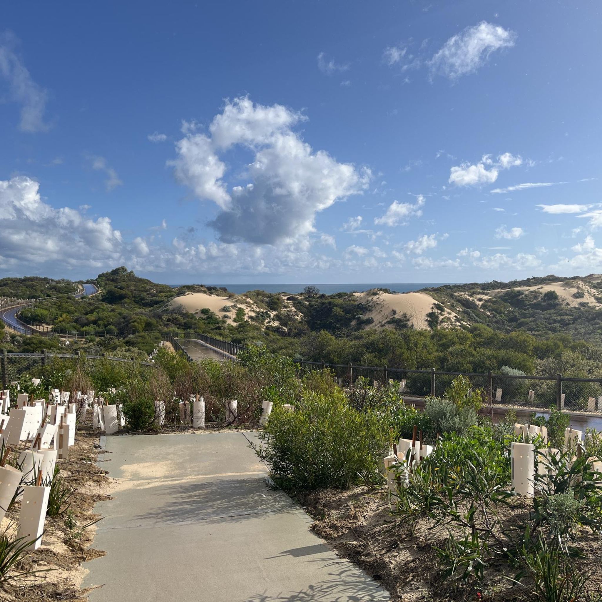
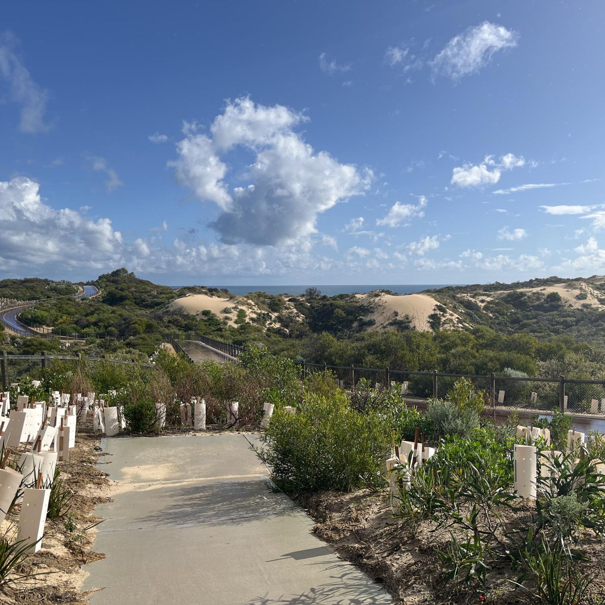
Hiking trails in Tamala Park Conservation Reserve feature a unique coastal environment with both vegetated and bare dunes, including ancient Spearwood and younger Quindalup dune systems. The landscape offers a scenic coastal path with intermittent views of the Indian Ocean and diverse coastal vegetation like Native Wisteria and Tuart trees. Hikers can explore areas characterized by these dunes and the surrounding bushland.
Best hiking trails in Tamala Park Conservation Reserve
- The most popular hiking route is Flemming Park Pond loop…
Last updated: August 27, 2026
36
hikers
2.73km
00:42
10m
10m
Easy hike. Great for any fitness level. Easily-accessible paths. Suitable for all skill levels.
14
hikers
7.02km
01:50
40m
40m
Easy hike. Great for any fitness level. Easily-accessible paths. Suitable for all skill levels.

Sign up for free
5.0
(1)
8
hikers
15.8km
04:11
160m
160m
Moderate hike. Good fitness required. Easily-accessible paths. Suitable for all skill levels.
4.0
(5)
21
hikers
17.7km
04:31
60m
60m
Moderate hike. Good fitness required. Easily-accessible paths. Suitable for all skill levels.
22
hikers
12.9km
03:17
40m
40m
Moderate hike. Good fitness required. Easily-accessible paths. Suitable for all skill levels.
Our route recommendations are based on thousands of hikes, rides, and runs completed by other people on komoot.
Start today with a free account
Your next adventure awaits.
Login or Signup
Tips from the Community

Burns Beach coastal path is a fantastic sealed shared path that follows the coastline, with uninterrupted views of the Indian Ocean, connecting Burns Beach with Mindarie and the wider Sunset Coast pathway network. The mostly level route passes along coastal heath, sandy dunes, and sheltered beaches, making it an ideal route for walking, running, and cycling in a beautiful setting.
0
0
Burns Beach is a beautiful stretch of white sand within Marmion Marine Park, popular for swimming, fishing, snorkelling, and watching spectacular Indian Ocean sunsets. Its clear water, limestone headlands, and grassy foreshore reserves create a relaxed setting that’s just as popular with families as it is with walkers exploring Perth’s Sunset Coast.
0
0
Sistas is a relaxed beachfront spot overlooking the Indian Ocean, making it a popular place to stop before or after a walk along the coast. It’s a great place to grab a coffee or a meal and enjoy the ocean views from the outdoor patio while watching the waves roll in.
0
0

Pinaroo Point is a popular beach and playground. When the wind is up you'll see kite surfers ripping across the water while the designated dog beach invites plenty of sea dogs to play. Hillary's Beach Club offers great food and drinks with plenty of seafood on the menu.
0
0
This is one of a series of shared-use paths that run along the coastline here. You'll be treated to a well-maintained paved path that passes through a number of parks and viewpoints and also various points that allow access to the beaches below.
0
0
This small park is perched on the cliffs above the beach, giving it a dramatic backdrop which has made it popular for weddings and photographers. The park also has access to the beach below, which opens up a world of recreational opportunities.
0
0
This shared-use path runs along the coastline, connecting beaches, parks, and communities along the way. Its popular for walking, jogging, and cycling and its west facing aspect making it especially scenic around sunset.
0
0
This beach is known for being a great option for long walks and stunning sunsets. You'll also the the Jindalee Beach Shack here, which serves a wide range of great food and drinks. Come for the beach and stay for the food, or vice versa as the case may be.
0
0
Frequently Asked Questions
How many hiking trails are available in Tamala Park Conservation Reserve?
Tamala Park Conservation Reserve offers a selection of 6 hiking routes, catering to various preferences. These include 2 easy trails and 4 moderate trails, ensuring options for different fitness levels.
What kind of terrain can I expect on the trails in Tamala Park Conservation Reserve?
The reserve features a unique coastal environment with both vegetated and bare dunes, including ancient Spearwood and younger Quindalup dune systems. You'll find a scenic coastal path with intermittent views of the Indian Ocean, as well as diverse coastal vegetation and bushland with resilient Tuart trees. The terrain generally involves gentle elevation changes, typical of coastal dune systems.
Are there any easy hiking options suitable for beginners or families?
Yes, there are easy options. For instance, the Flemming Park Pond loop from Clarkson is an easy 3.3-mile (5.3 km) trail that takes about 1 hour 22 minutes to complete, offering views of the local pond and parkland. Another easy 1.1-mile path with minimal elevation is also available within the reserve.
What are the notable natural features or viewpoints I can see while hiking?
Hikers can explore ancient Spearwood and younger Quindalup Dune systems, which formed between 2,000 and 10,000 years ago. A large parabolic dune is a notable feature. From vantage points like Stop 7 on the South Mindarie Foreshore Trail, you can enjoy extensive views of Tamala Conservation Park and surrounding bushland. You'll also see diverse coastal vegetation, including purple Native Wisteria, white-flowering Basket Bush, and stands of Tuart trees. Burns Rocks, marking the northern boundary of the Marmion Marine Park, can also be viewed.
What wildlife might I encounter during a hike in Tamala Park Conservation Reserve?
The reserve and its adjacent areas are home to a variety of wildlife. You might spot Western Grey Kangaroos, quendas, and Southwestern snake-necked turtles. Birdlife is also rich, with approximately 120 species inhabiting the nearby Lake Joondalup, and Galahs and New Holland Honeyeaters observed within the reserve itself.
Are there any circular hiking routes in the reserve?
Yes, there are circular routes available. The Flemming Park Pond loop from Clarkson is an easy circular trail. For a longer option, the Lake Joondalup Circuit, while adjacent to the reserve, is a popular 11.0-mile (17.7 km) loop that takes about 4 hours 31 minutes.
What is the best time of year to go hiking in Tamala Park Conservation Reserve?
While specific seasonal advice isn't provided, the coastal nature of the reserve suggests that spring and autumn would likely offer the most pleasant hiking conditions, avoiding the intense heat of summer and potential winter rains. Always check local weather forecasts before heading out.
Where can I park when visiting Tamala Park Conservation Reserve for a hike?
Specific parking locations within Tamala Park Conservation Reserve are not detailed, but access points to trails like the South Mindarie Foreshore Trail would likely have designated parking areas. It is advisable to check local signage upon arrival or consult maps for official parking facilities near trailheads.
Are there public transport options to reach the hiking trails?
Information on direct public transport to the trailheads within Tamala Park Conservation Reserve is limited. However, the reserve is integrated into a broader trail network, and areas like Clarkson, from which the Flemming Park Pond loop starts, are typically accessible by public transport. For detailed public transport routes, it's best to consult local transport authority websites.
What do other hikers say about their experience in Tamala Park Conservation Reserve?
The routes in Tamala Park Conservation Reserve are highly rated by the komoot community, with an average score of 4.25 stars from more than 5 reviews. Hikers often praise the unique coastal environment, the variety of dune systems, and the diverse bushland, making for an engaging outdoor experience.
Are there any amenities or places to eat near the reserve?
While the reserve itself is largely natural, nearby Neil Hawkins Park and Studmaster Park offer amenities such as playgrounds, picnic areas, and barbecues. For cafes, pubs, or accommodation, you would need to look to the surrounding suburbs like Clarkson or Joondalup.
What are the typical durations for hikes in the reserve?
Hike durations vary depending on the trail's length and difficulty. Easy routes, such as the Flemming Park Pond loop, can be completed in about 1 hour 22 minutes. Longer, moderate trails like the Lake Joondalup Circuit can take around 4 hours 31 minutes, and the Yaberoo Budjara Heritage Trail section 2 takes approximately 4 hours 11 minutes.
Are there longer, more challenging hikes available in or near the reserve?
Yes, for those seeking longer excursions, the Yaberoo Budjara Heritage Trail section 2: Burns Beach Road to Hester Road is a moderate 9.8-mile (15.8 km) path that traverses coastal bushland. Another substantial option is the Lake Joondalup Circuit, an 11.0-mile (17.7 km) moderate trail adjacent to the reserve.
Most popular routes in Tamala Park Conservation Reserve

Get inspired with the komoot mobile app


Explore more
Browse the best Hikes in other regions.
