Attractions and Places To See around Mastershausen - Top 20
Best attractions and places to see around Mastershausen, a municipality in the Hunsrück region of Germany, offers a diverse range of attractions. The area is characterized by dense forests, picturesque valleys, and historical landmarks. It is well-suited for outdoor enthusiasts, providing numerous opportunities for hiking and cycling. Visitors can explore natural features, cultural sites, and traditional architecture.
Best attractions and places to see around Mastershausen
- The most popular attractions is Geierlay suspension rope bridge, a bridge that is one of Europe's longest suspended rope bridges. It stretches 360 meters and reaches a maximum height of almost 100 meters above the ground.
- Another must-see spot is Beilstein, a settlement with one of the best-preserved historic sites on the Moselle. Visitors can expect a village with half-timbered houses and a castle ruin, often referred to as the "Sleeping Beauty of the Moselle."
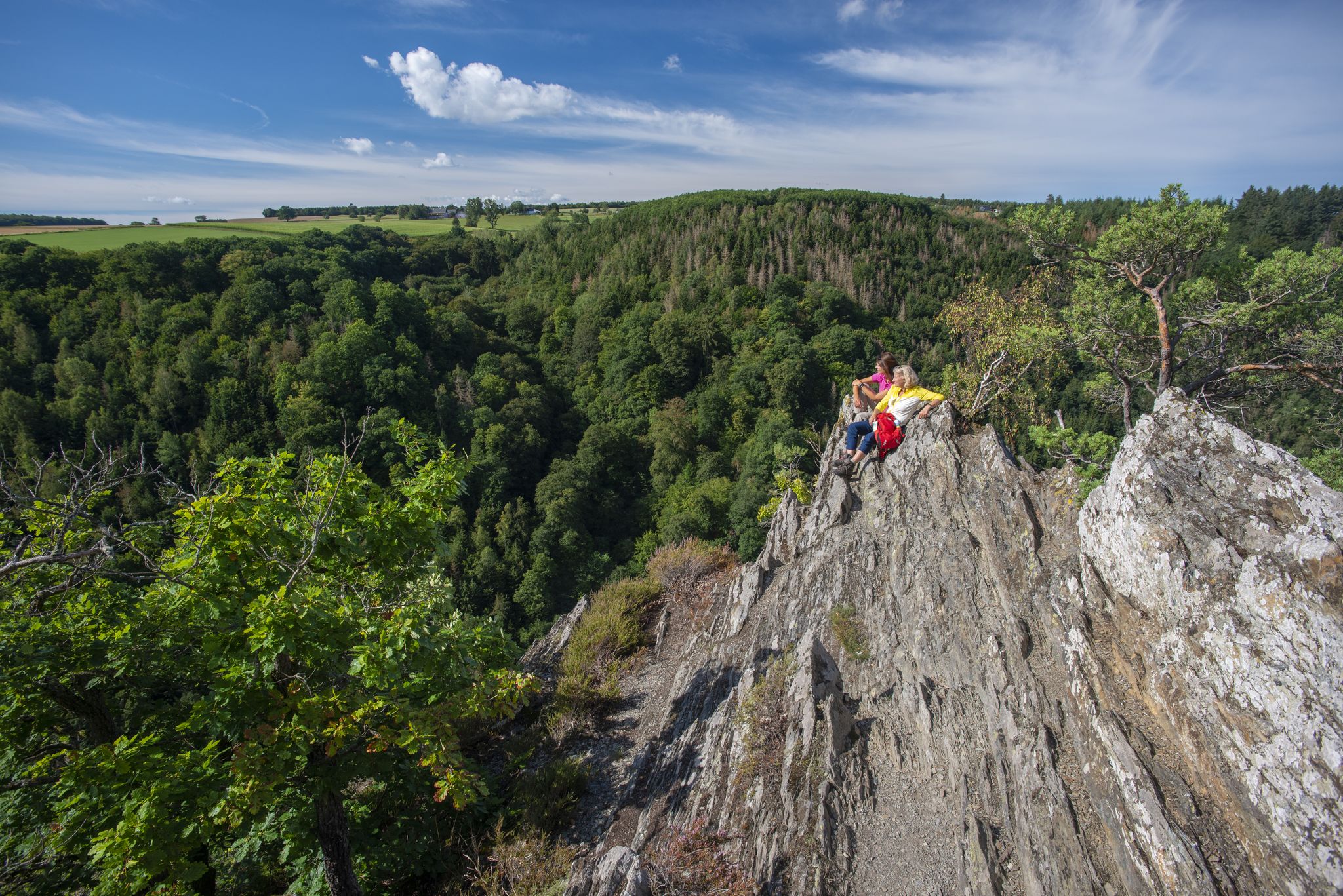
- Visitors also love View of Beilstein and Metternich Castle, a viewpoint offering historical insights into the region. This spot provides views of a village full of romance, with old houses, a monastery, and ancient castle ruins.
- Mastershausen is known for bridges, historical sites, and viewpoints. The region offers a variety of attractions to see and explore, from natural landscapes to cultural landmarks.
- The attractions around Mastershausen are appreciated by the komoot community, with more than 5800 upvotes and over 6600 photos shared by visitors.
Last updated: May 26, 2026
Geierlay suspension rope bridge
Highlight (Segment) • Bridge
The name of the bridge is taken from the field name of the district on which the bridge is located: A rocky slope called Geierslay, which probably got this name, because in the vicinity of the rock (see also Ley) numerous birds of prey live. The word "vulture", derived from the Middle High German "gir" as a noun of "greedy", is still a trivial term for a number of different species of birds of prey.
The overall concept of the Geierlay includes a visitor center with a large pay parking, also for coaches. In the visitor center there is a bistro. The bridge itself can only be reached on foot or by bike over 1.8 km of well-paved path. For the way back I do not recommend the same way over the bridge, but through the valley below, which is very nice.
Translated by Google •
Tip by

Beilstein
Highlight • Settlement
Translated by Google •
Tip by

Sign up now to discover places like this
Get recommendations on the best single tracks, peaks, & plenty of other exciting outdoor places.
Sign up for free
View of Beilstein and Metternich Castle
Highlight • Viewpoint
Franconian grave finds show Beilstein's settlement around 800 AD. The place had been a feudal possession of the Lords of Braunshorn since 1268. Under Johann von Braunshorn (1299–1346), Beilstein received city privileges from King Henry VII in 1309 and was fortified. A Jewish community has been documented since 1309, and its Jewish cemetery above the castle still exists today. The former parish church was founded in 1310. After the von Braunshorn family died out, the fief passed to the von Winneburg family in 1360. After Kurtrier took possession of Beilstein in 1488, the Imperial Counts of Metternich enfeoffed the rule of Winneburg and Beilstein in 1652. In 1689, Metternich Castle (“The Proud Walls”) was destroyed by French troops. A Carmelite monastery was founded in 1636 (abolished in 1803), and the foundation stone of the Carmelite monastery church was laid in 1691, which was completed in 1783. The townscape was created in the 17th and 18th centuries and has largely been preserved to this day. The rule of the Imperial Counts of Metternich ended in 1794 with the occupation by French revolutionary troops. From 1798 to 1814 the place belonged to the canton of Zell in the Rhine-Moselle department and was the main town of a Mairie. In 1815 the place was assigned to the Kingdom of Prussia at the Congress of Vienna and belonged to the Senheim mayor's office in the Zell district. It has been part of the state of Rhineland-Palatinate since 1946.
Source: wikipedia
Translated by Google •
Tip by

Mörsdorfer Bach Bridge Crossing
Highlight • Bridge
Translated by Google •
Tip by

View from beneath the Geierlay Suspension Bridge
Highlight • Bridge
Translated by Google •
Tip by

Sign up for free to discover even more attractions around Mastershausen.
Sign up for free
Already have an account?
Start today with a free account
Your next adventure awaits.
Login or Signup
Other adventures around Mastershausen

Tips from the Community

Beilstein "The Sleeping Beauty of the Moselle" One of the most beautiful towns on the Moselle, also known as the Sleeping Beauty of the Moselle. We Beilsteiners always strive to treat our guests warmly and kindly and to welcome them as friends when they return to visit us again and again, often for decades. Text / Source: Beilstein Mosel, Bachstr. 47, 56814 Beilstein https://beilstein-mosel.de/
15
1

From pretty stream to over there stream… without getting your feet wet… in some places there is even a ford
9
0
Beautiful views of the bridges from the side... here you can see how much it sags
12
0

If you want to avoid the many visitors who cross the bridge in procession, especially when the weather is nice, you should be at the bridge by 10:00 a.m. at the latest. The bridge can be accessed from both directions and there are several wooden benches and wooden loungers at the entrance points so you can enjoy this impressive masterpiece of engineering.
37
6

That's pretty high if you look from the bottom up. :-)
10
0

Good view of the suspension bridge.
11
0
Great view of the Geierley.
12
0

History (for those who are interested :-) Franconian grave finds show Beilstein's settlement around 800 AD. The place had been a feudal possession of the Lords of Braunshorn since 1268. Under Johann von Braunshorn (1299–1346), Beilstein received city privileges from King Henry VII in 1309 and was fortified. A Jewish community has been documented since 1309, and its Jewish cemetery above the castle still exists today. The former parish church was founded in 1310. After the von Braunshorn family died out, the fief passed to the von Winneburg family in 1360. After Kurtrier took possession of Beilstein in 1488, the Imperial Counts of Metternich enfeoffed the rule of Winneburg and Beilstein in 1652. In 1689, Metternich Castle (“The Proud Walls”) was destroyed by French troops. A Carmelite monastery was founded in 1636 (abolished in 1803), and the foundation stone of the Carmelite monastery church was laid in 1691, which was completed in 1783. The townscape was created in the 17th and 18th centuries and has largely been preserved to this day. The rule of the Imperial Counts of Metternich ended in 1794 with the occupation by French revolutionary troops. From 1798 to 1814 the place belonged to the canton of Zell in the Rhine-Moselle department and was the main town of a Mairie. In 1815 the place was assigned to the Kingdom of Prussia at the Congress of Vienna and belonged to the Senheim mayor's office in the Zell district. It has been part of the state of Rhineland-Palatinate since 1946. Source: wikipedia
14
1
Frequently Asked Questions
What natural features can I explore around Mastershausen?
Mastershausen is nestled in the Hunsrück region, offering a diverse landscape of dense forests and picturesque valleys. You can explore the deeply cut narrow valley of the Mastershausen stream, which is part of the Masdascher Burgherrenweg premium hiking trail. The Simmerbach Valley is another impressive natural highlight, featuring waterfalls and small lakes, ideal for enjoying tranquility and discovering local flora and fauna.
Are there any historical sites or cultural landmarks in Mastershausen?
Yes, Mastershausen offers several historical and cultural points of interest. You can visit the ruins of Burg Balduinseck, a 14th-century castle. The St. Lucy's Catholic Parish Church with its Romanesque west tower and 1965 new building is also notable. The village center itself features traditional timber-frame buildings, and you can find historic wayside crosses and boundary stones in the surrounding area, such as the 19th-century Kaspersmühle with its waterwheel.
What outdoor activities are available near Mastershausen?
The region around Mastershausen is excellent for outdoor enthusiasts. You can enjoy extensive hiking and cycling tours through the Hunsrück Mountains and Rhine Valley. For specific routes, consider exploring the running trails, MTB trails, or cycling routes available, which include paths leading to the Geierlay Suspension Bridge and other scenic spots.
Are there family-friendly attractions or activities in the area?
Many attractions around Mastershausen are suitable for families. The Geierlay suspension rope bridge offers an exciting experience for all ages, with a well-paved path leading to it. The nearby settlement of Beilstein, known as the 'Sleeping Beauty of the Moselle,' provides a charming village atmosphere with half-timbered houses and castle ruins that families can explore. Many hiking trails, such as the Mörsdorfer Bach Bridge Crossing, are also suitable for family walks.
Where can I find impressive viewpoints around Mastershausen?
The region boasts several stunning viewpoints. The Geierlay suspension rope bridge itself offers breathtaking views from its height of almost 100 meters. For a unique perspective, you can also experience the View from beneath the Geierlay Suspension Bridge. Additionally, the View of Beilstein and Metternich Castle provides picturesque vistas of the historic village and its castle ruins along the Moselle.
What are some popular hiking trails near Mastershausen?
One of the most popular trails is the Masdascher Burgherrenweg, a 13.9 km premium circular hiking trail voted Germany's 'Most Beautiful Hiking Trail' in 2018. This trail offers impressive views and cultural highlights through the Mastershausen stream valley. Many routes also incorporate the Geierlay suspension rope bridge, allowing you to cross it and explore the valley below.
Is the Geierlay Suspension Bridge accessible, and what should I know before visiting?
The Geierlay suspension rope bridge is freely accessible year-round, except during storms. It stretches 360 meters and is nearly 100 meters high. There is a visitor center with paid parking and a bistro. The bridge itself can only be reached on foot or by bike via a 1.8 km well-paved path. Many visitors recommend taking a circular route, crossing the bridge and then returning through the valley below for varied perspectives.
Are there any dog-friendly trails or attractions?
Many of the outdoor trails and natural areas around Mastershausen are dog-friendly, allowing you to explore with your canine companion. The village of Beilstein is also noted as dog-friendly, making it a pleasant stop for you and your pet. Always ensure dogs are kept on a leash where required and respect local regulations.
What is the best time of year to visit Mastershausen for outdoor activities?
The Hunsrück region, including Mastershausen, is ideal for outdoor activities from spring through autumn. Spring brings blooming landscapes, while summer offers pleasant temperatures for hiking and cycling. Autumn is particularly scenic with vibrant fall foliage. The Geierlay suspension rope bridge is open year-round, making it a destination even in milder winter conditions, though always check weather conditions.
What kind of traditional architecture can I see in Mastershausen?
Mastershausen has preserved several historic timber-frame buildings that showcase the traditional architecture of the Hunsrück region. The village center itself offers a timeless charm with quaint streets and traditional half-timbered houses. The Kaspersmühle, a one-floor timber-frame building from the 19th century, is another excellent example of the area's historical structures.
Are there options for public transport to reach trailheads or attractions?
While Mastershausen is best explored by car or bike, some public transport options may connect to nearby towns. For specific trailheads or attractions, it's advisable to check local bus schedules or regional transport services. The visitor center for the Geierlay suspension rope bridge, for instance, is a key hub with parking, and the bridge itself is accessible via a 1.8 km path.
What are some unique or 'hidden gem' attractions in the Hunsrück region near Mastershausen?
Beyond the well-known sites, the Hunsrück region around Mastershausen holds charming discoveries. The tranquil Simmerbach Valley with its waterfalls and small lakes offers a peaceful escape. Exploring the quaint streets of Mastershausen village center itself, with its traditional half-timbered houses and blooming flower gardens, can feel like stepping back in time. The historic Kaspersmühle, a 19th-century timber-frame mill with a waterwheel, is another delightful find.
Most popular routes around Mastershausen
Most popular attractions around Mastershausen

Get inspired with the komoot mobile app


Explore more
Still not found the Highlight you’re looking for? See guides of the top attractions in other regions:
