The best cycling routes in Atlautla
4.8
(8)
74
riders
9
rides
Touring cycling routes in Atlautla, Mexico, traverse a region characterized by dramatic mountainous landscapes and significant natural features. The area is defined by its impressive terrain, including the prominent Popocatépetl volcano and 14 named mountains. Coniferous forests and high mountain passes contribute to the diverse scenery. Elevation changes are significant, providing varied experiences for touring cyclists.
Best touring cycling routes in Atlautla
- The most popular touring cycling route is Route of the Volcanoes – Paso de Cortés loop from Amecameca…
Last updated: July 2, 2026
4.0
(3)
30
riders
50.2km
03:53
1,330m
1,330m
Hard bike ride. Very good fitness required. Mostly paved surfaces. Suitable for all skill levels.
5.0
(2)
29
riders
35.9km
02:57
1,150m
1,150m
Hard bike ride. Very good fitness required. Mostly paved surfaces. Suitable for all skill levels.

Sign up for free
3
riders
10.4km
01:07
230m
230m
Moderate bike ride. Good fitness required. Mostly paved surfaces. Suitable for all skill levels.
3
riders
17.6km
01:38
440m
440m
Moderate bike ride. Good fitness required. Mostly paved surfaces. Suitable for all skill levels.
2
riders
17.0km
01:04
80m
80m
Easy bike ride. Great for any fitness level. Mostly paved surfaces. Suitable for all skill levels.
Get access to more routes and recommendations from other explorers.
Sign up for free
Already have an account?
Our route recommendations are based on thousands of hikes, rides, and runs completed by other people on komoot.
Start today with a free account
Your next adventure awaits.
Login or Signup
Popular around Atlautla
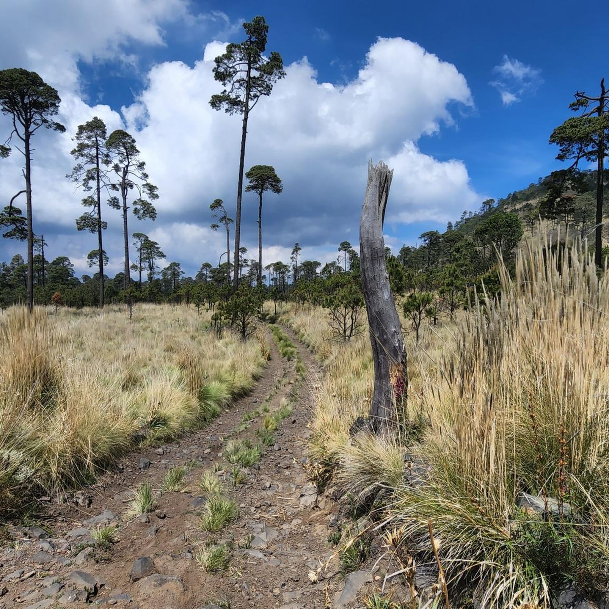
Tips from the Community


The air is getting quite thin once you get closer to the top. Allow yourself enough time to get up there. We had to take a lot of breaks and needed around 4 to 5 hours to get there!
1
0

Starting point for hikes on the volcanoes. Located at 3,600 meters, the air is much thinner.
2
0

From here you will be able to appreciate, if the weather allows it, our famous active volcano, Popocatépetl, which is majestic at all times of the year. Of course there are more points where you can appreciate it, but riding a bike and being able to enjoy it on the move is the best.
2
0
Frequently Asked Questions
What are the typical elevation changes I can expect on touring cycling routes in Atlautla?
Atlautla is characterized by its impressive mountainous terrain, including the prominent Popocatépetl volcano. Touring cycling routes here feature significant elevation changes, offering a challenging yet rewarding experience. For example, the Route of the Volcanoes – Paso de Cortés loop from Amecameca involves over 1,300 meters of ascent, while easier routes like the Parque Amecameca loop from Amecameca have more modest climbs of around 80 meters.
Are there any family-friendly touring cycling routes in Atlautla?
Yes, Atlautla offers routes suitable for various ability levels, including easier options that can be enjoyed with family. The Parque Amecameca loop from Amecameca is an easy 17 km path that provides an accessible experience through the lower elevations of the park, making it a good choice for families.
What natural features or landmarks can I expect to see while cycling in Atlautla?
While touring cycling in Atlautla, you'll encounter dramatic mountainous landscapes, including views of the iconic Popocatépetl volcano and other peaks. The routes often traverse coniferous forests and high mountain passes within the Parque Nacional Iztaccíhuatl-Popocatépetl. You might also spot diverse wildlife such as the volcano rabbit, Mexican bobcat, and white-tailed deer in forested and meadow areas.
When is the best time of year for touring cycling in Atlautla?
Given Atlautla's mountainous terrain and significant elevation, the best time for touring cycling is typically during the dry season, which generally runs from November to May. This period offers more stable weather conditions and clearer views of the volcanoes, avoiding the heavier rains that can occur during the summer months.
Are there many circular touring cycling routes available in Atlautla?
Yes, many of the touring cycling routes in Atlautla are designed as loops, allowing you to start and end at the same point. Examples include the popular Route of the Volcanoes – Paso de Cortés loop from Amecameca and the Summit of Popocatépetl – Paso de Cortés loop from Paso de Cortés, which offer varied experiences through volcanic landscapes and forests.
What is the overall difficulty range of touring cycling routes in Atlautla?
Atlautla offers a diverse range of touring cycling routes catering to different skill levels. You'll find easy loops, such as the Parque Amecameca loop from Amecameca, as well as moderate and demanding climbs like the Route of the Volcanoes – Paso de Cortés loop from San Pedro Nexapa, which features significant elevation gain over its 36 km.
What do other touring cyclists enjoy the most about touring cycling in Atlautla?
The touring cycling routes in Atlautla are highly rated by the komoot community, with an average score of 4.75 stars from over 8 reviews. Cyclists often praise the dramatic mountainous landscapes, the scenic views of the Popocatépetl volcano, and the diverse experience offered by routes traversing coniferous forests and high mountain passes.
Are there any shorter touring cycling routes for a quick ride?
Yes, if you're looking for a shorter ride, the Summit of Popocatépetl – Paso de Cortés loop from Paso de Cortés is a moderate 10.4 km trail that can typically be completed in about 1 hour and 7 minutes, offering a taste of the volcanic landscapes.
What kind of terrain can I expect on Atlautla's touring cycling routes?
The terrain in Atlautla is varied, reflecting its mountainous nature. You can expect a mix of paved sections and potentially unpaved segments, especially on more challenging routes that delve deeper into the natural park. The routes often wind through coniferous forests and volcanic landscapes, providing a diverse and engaging cycling experience.
How many touring cycling routes are available in Atlautla?
There are approximately 9 touring cycling routes available in Atlautla, offering a good selection for different preferences and skill levels. These include 2 easy, 3 moderate, and 4 difficult routes, ensuring options for everyone from casual riders to experienced cyclists.
Are there any longer, more challenging touring cycling routes in the region?
For experienced touring cyclists seeking a challenge, Atlautla offers several demanding routes. The Route of the Volcanoes – Parque Amecameca loop from Parque Nacional Sacromonte is a difficult 30 km route with over 660 meters of ascent, providing a strenuous yet rewarding ride through the region's volcanic landscapes.
Can I find routes that explore the Parque Nacional Iztaccíhuatl-Popocatépetl?
Many touring cycling routes in Atlautla are situated within or offer access to the Parque Nacional Iztaccíhuatl-Popocatépetl, allowing you to explore its natural beauty. Routes like the Parque Amecameca loop from Parque Nacional Sacromonte provide an excellent way to experience the park's diverse terrain and scenic views.

Get inspired with the komoot mobile app


Explore more
Browse the best Cycling routes in other regions.
