The best walks and hikes around Hutton And Paxton
4.6
(134)
1,487
hikers
85
hikes
Hiking around Hutton And Paxton offers diverse routes through the Scottish Borders, characterized by traditional country villages, farmlands, and woodlands. The region is prominently shaped by the River Tweed, which forms part of the border between England and Scotland. Hikers can explore a blend of riverine scenery, historical landmarks, and pastoral landscapes. The terrain includes gentle riverside paths and more varied trails connecting villages and natural features.
Best hiking trails around Hutton And Paxton
- The most popular hiking route is…
Last updated: August 4, 2026
4.5
(4)
27
hikers
4.21km
01:07
40m
40m
Easy hike. Great for any fitness level. Easily-accessible paths. Suitable for all skill levels.
5.0
(1)
22
hikers
19.9km
05:08
110m
110m
Hard hike. Very good fitness required. Easily-accessible paths. Suitable for all skill levels.

Sign up for free
4.3
(3)
22
hikers
4.00km
01:04
40m
40m
Easy hike. Great for any fitness level. Easily-accessible paths. Suitable for all skill levels.
5.0
(1)
18
hikers
Easy hike. Great for any fitness level. Easily-accessible paths. Suitable for all skill levels.
4.0
(2)
10
hikers
14.8km
03:54
130m
130m
Moderate hike. Good fitness required. Easily-accessible paths. Suitable for all skill levels.
Get access to more routes and recommendations from other explorers.
Sign up for free
Already have an account?
Our route recommendations are based on thousands of hikes, rides, and runs completed by other people on komoot.
Start today with a free account
Your next adventure awaits.
Login or Signup
Tips from the Community

Prior to the stone structure, wooden bridges served the crossing but were destroyed by floods and conflict. James Burrell, Surveyor of Works, recommended a stone bridge after ice destroyed the wooden one in 1608. Despite funding issues and changing designs, construction of the stone bridge began in 1611. It faced challenges, including a flood in 1621, but was completed and opened by 1624. The bridge's importance for main road traffic later declined with the construction of newer crossings. It is now a Grade I listed building and scheduled monument.
0
0

As seen on ‘Whatever Happened to the Likely Lads' and latterly 'Vera'
0
0
Norham Cross is a historic market cross located near Norham Castle and St Cuthbert's Church. It dates back to the 12th or 13th century, making it an important part of the area's medieval heritage. The cross, constructed from sandstone, features a clustered shaft with a moulded base and plain plinth. While the upper part of the shaft and the weather vane were added in the 19th century, the core structure remains largely intact
0
0

This is a great location to view the large railway bridge from. It is an impressive sight to see from this anlge
1
0


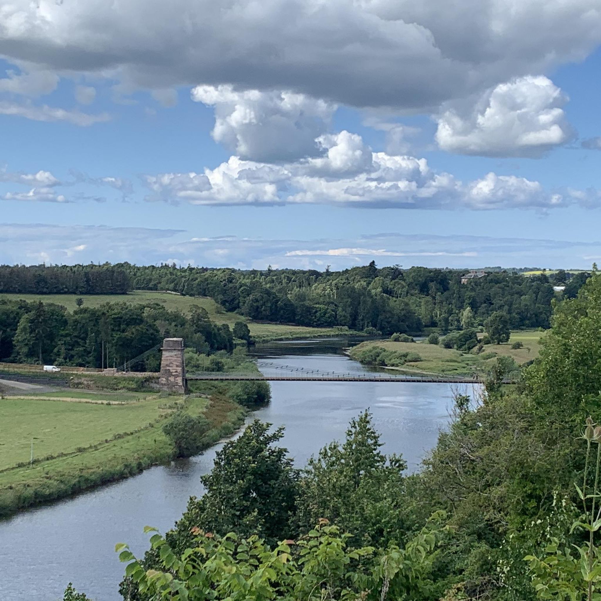
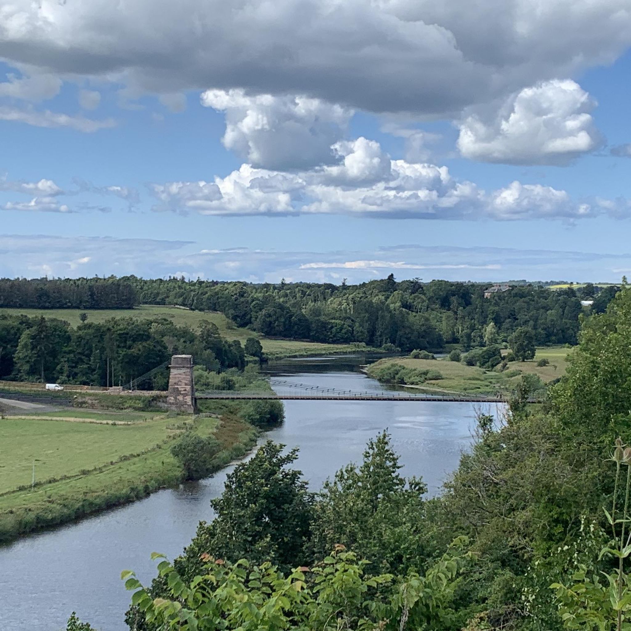
This spot is an excellent viewpoint over the River Tweed and it's impressive chain bridge. The Union Chain Bridge, also known as the Union Bridge, is a historic suspension bridge that crosses the River Tweed, connecting Horncliffe in Northumberland, England, to Fishwick in Berwickshire, Scotland. This structure, inaugurated in 1820, held the distinction of being the world's longest wrought iron suspension bridge at the time, boasting a remarkable span of 449 feet (137 m).
0
0
Norham stands as one of the most captivating sights in the border region. Perched atop a lush hillock, it commands a crucial ford over the River Tweed, having held immense significance as a formidable stronghold in this historically turbulent area. It endured frequent assaults from the Scots, facing no less than 13 sieges, including a nearly year-long encirclement led by Robert Bruce. Despite the strength of its robust 12th-century keep and imposing towered bailey walls, it ultimately succumbed to the might of James IV's formidable cannons in 1513, just prior to his fateful defeat at Flodden Field. The extensive reconstruction during the 16th century, tailored to accommodate artillery, still bears evident marks, showcasing the fortress's adaptation to changing times.
0
0
Frequently Asked Questions
How many hiking trails are available in Hutton And Paxton?
There are over 80 hiking trails around Hutton And Paxton, offering a wide variety of experiences. These routes traverse traditional country villages, farmlands, and woodlands, with many following the scenic River Tweed.
What kind of terrain can I expect on hikes around Hutton And Paxton?
The terrain around Hutton And Paxton is diverse, featuring a blend of traditional country villages, expansive farmlands, and thriving woodlands. Many routes follow the River Tweed, offering picturesque riverine scenery. You'll find paths ranging from gentle riverside strolls to more varied trails connecting villages and natural features.
Are there hiking options for all skill levels in Hutton And Paxton?
Yes, the area caters to various fitness levels. Out of 86 available routes, 55 are rated as easy, 30 as moderate, and there is 1 difficult trail. This ensures that both casual walkers and experienced hikers can find suitable paths.
What historical landmarks or natural features can I see while hiking?
The region is rich in historical and natural attractions. You can explore the historic Norham Castle Ruins, walk along the Berwick Town Walls, or admire the impressive Union Bridge (Tweed). The River Tweed itself is a prominent natural feature, offering beautiful views and opportunities for riverside walks.
Can I combine hiking with a visit to a historic estate?
Yes, the area features Paxton House, an 18th-century neo-Palladian mansion with expansive grounds that include family outdoor trails. Circular walks, such as the "Paxton House to Union Chain Bridge Circular," often integrate this historical estate with the natural beauty of the area, providing a cultural and scenic experience.
Are there many circular walking routes in the area?
Yes, Hutton And Paxton offer numerous circular walking routes. For example, the Union Chain Bridge – Statue of Captain Samuel Brown loop from Horncliffe is an easy 4 km circular trail. Many routes are designed as loops, allowing you to start and end at the same point.
Are the trails around Hutton And Paxton suitable for families?
Many trails in Hutton And Paxton are suitable for families, especially the easier routes. The area's blend of woodlands and farmlands provides engaging scenery for children. Paxton House also offers specific family outdoor trails within its grounds. Look for routes marked as 'easy' for the most family-friendly options.
Can I bring my dog on the hiking trails?
Generally, dogs are welcome on many trails in the Scottish Borders, including those around Hutton And Paxton. However, it's always advisable to keep dogs on a lead, especially when passing through farmland with livestock or in areas with ground-nesting birds. Please respect local signage and clean up after your pet.
What is the best time of year to go hiking in Hutton And Paxton?
The region offers pleasant hiking experiences throughout much of the year. Spring and summer bring lush greenery and longer daylight hours, ideal for exploring. Autumn provides beautiful fall colors in the woodlands. While winter hikes are possible, be prepared for colder, potentially wetter conditions and shorter daylight.
What do other hikers enjoy the most about hiking in Hutton And Paxton?
The area is highly rated by the komoot community, with an average score of 4.6 stars from over 100 reviews. Hikers often praise the picturesque riverine scenery, the historical landmarks like the Union Chain Bridge, and the peaceful blend of farmlands and woodlands that define the region.
Are there any challenging long-distance hikes available?
Yes, for those seeking a more challenging experience, there is at least one difficult route. The Berwick Bridge (Old Bridge) – Royal Border Bridge loop from Horncliffe is a difficult 20 km path that offers extensive views along the River Tweed and its iconic bridges, providing a full day's adventure.
Where can I find more information about local paths and walking routes?
For additional information on local paths and walking routes, particularly around Chirnside and Paxton, you can consult resources provided by the local council. The Scottish Borders Council offers details on various paths in the area, which can be found on their website: scotborders.gov.uk.
Most popular routes around Hutton And Paxton
Most popular attractions around Hutton And Paxton

Get inspired with the komoot mobile app


Explore more
Browse the best Hikes in other regions.
