The best walks and hikes around Vilarinho Das Cambas
4.3
(15)
92
hikers
15
hikes
Hiking around Vilarinho Das Cambas, a parish within Vila Nova de Famalicão, offers a varied landscape for outdoor activities. The region is characterized by a blend of rural and agricultural areas, forested sections, and proximity to the Ave River. Trails often traverse serene countryside and provide access to historical sites such as ancient hillforts and medieval bridges. This environment provides diverse experiences for different fitness levels.
Best hiking trails around Vilarinho Das Cambas
- The most popular hiking route is Parque…
Last updated: June 26, 2026
3.8
(4)
22
hikers
7.53km
01:59
70m
70m
Easy hike. Great for any fitness level. Easily-accessible paths. Suitable for all skill levels.
4.5
(2)
10
hikers
16.2km
04:51
530m
530m
Moderate hike. Good fitness required. Easily-accessible paths. Suitable for all skill levels.

Sign up for free
5.0
(2)
6
hikers
15.1km
04:06
220m
220m
Moderate hike. Good fitness required. Easily-accessible paths. Suitable for all skill levels.
5.0
(1)
4
hikers
9.98km
02:49
200m
200m
Moderate hike. Good fitness required. Easily-accessible paths. Suitable for all skill levels.
2
hikers
10.1km
02:44
130m
140m
Moderate hike. Good fitness required. Easily-accessible paths. Suitable for all skill levels.
Get access to more routes and recommendations from other explorers.
Sign up for free
Already have an account?
Our route recommendations are based on thousands of hikes, rides, and runs completed by other people on komoot.
Start today with a free account
Your next adventure awaits.
Login or Signup
Tips from the Community

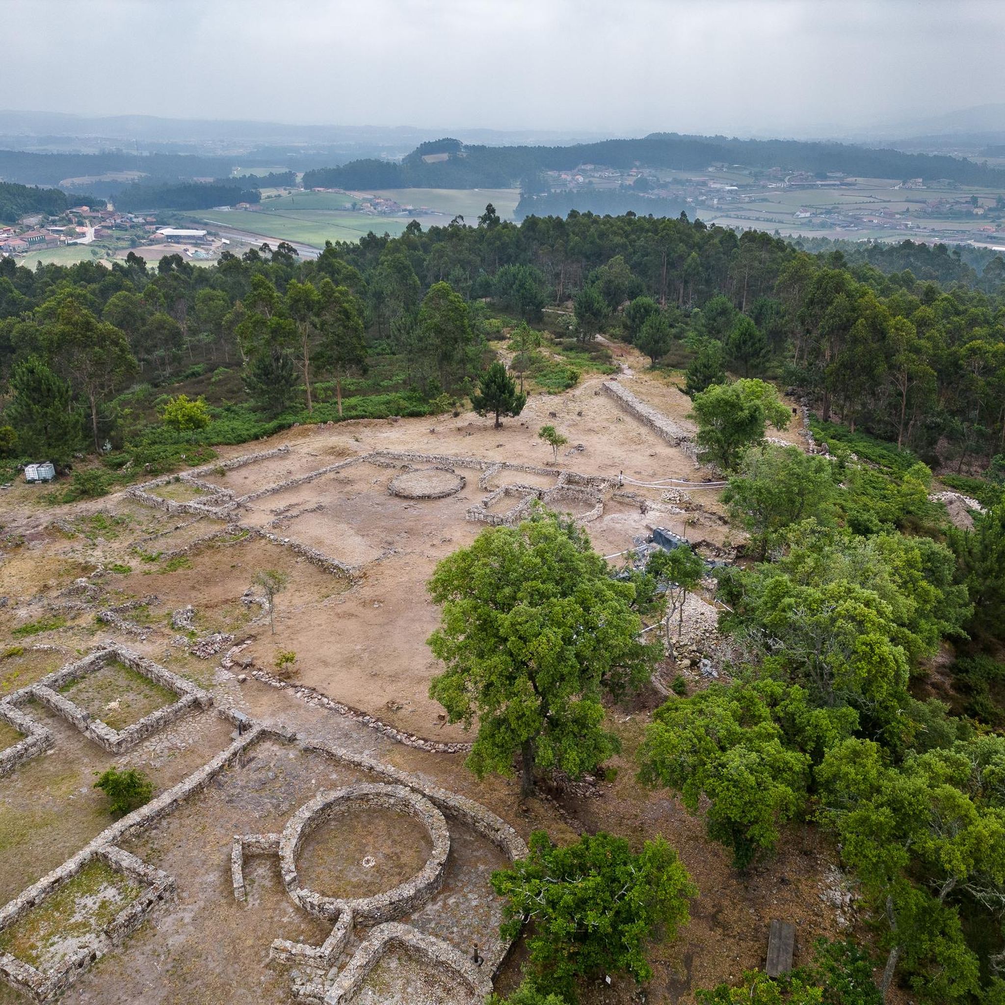
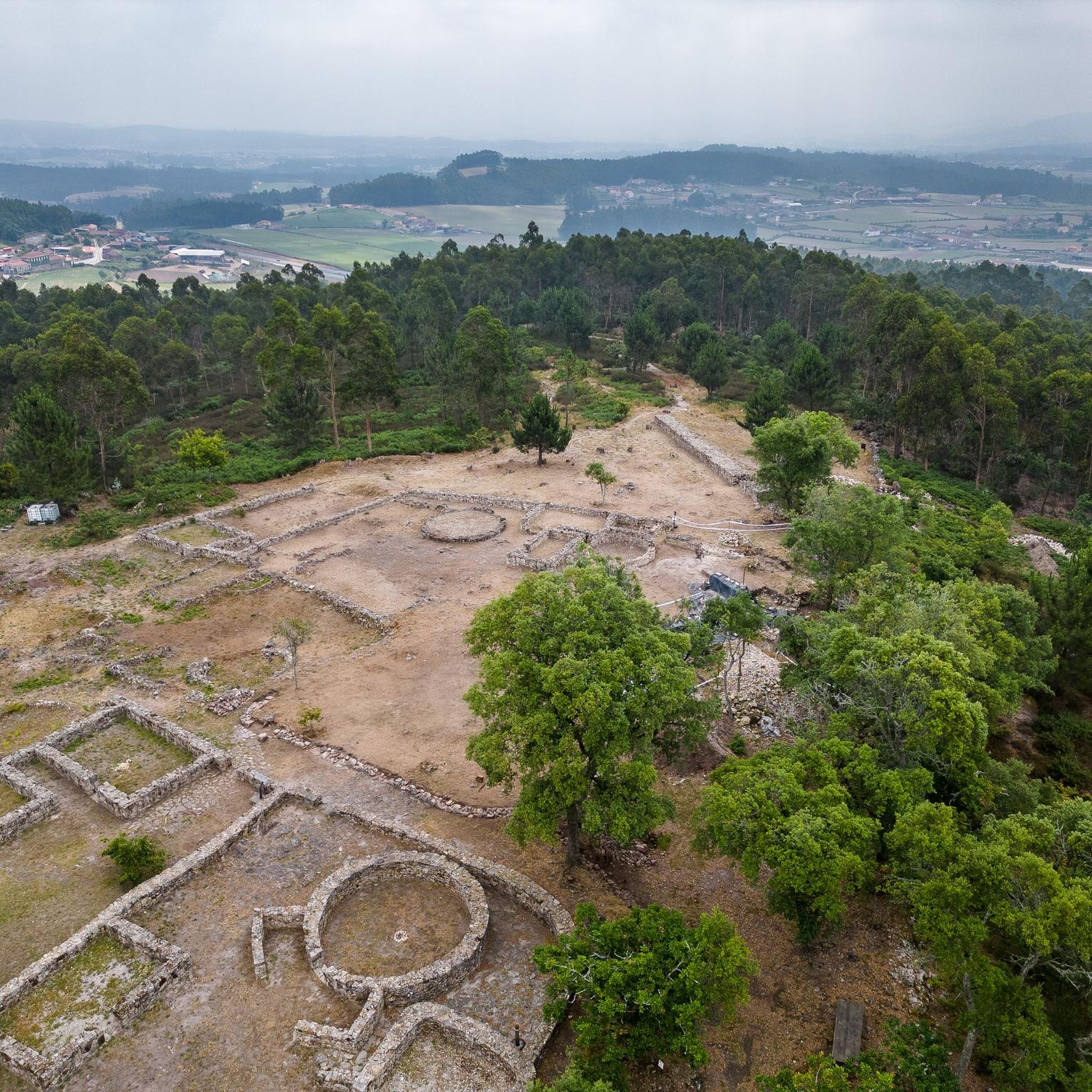
Nearby Tourist Attractions Ave Riverbank Promenade: A riverside walkway, ideal for relaxing strolls. Monte Padrão Hillfort: Ancient ruins for those interested in history and archaeology.
1
0
Highlights and Architecture Main Church: Built between 1659 and 1679, the monastery church is an imposing example of local religious architecture. Cloisters: The monastery has serene cloisters, one of which still displays a Gothic sculpture of the Virgin and Child in one of the corners. Cloister Fountain: In the center of the cloister stands a slender granite fountain with a polylobed basin, dating from 1649. Style: Over the centuries, the monastery has been rebuilt, combining Baroque and Neoclassical elements.
1
0
Opening Hours and Visits The monastery is open for visits, but guided tours of the cloisters and other areas (besides the church) generally require prior booking by telephone with the Santo Tirso City Hall office. General Hours (Church): Daily (Monday to Sunday): 08:00–12:00 and 15:00–19:00. Accessibility: The entrance and parking are wheelchair accessible.
1
0
The Monastery of São Bento, also known as the Monastery of Santo Tirso, is located on the left bank of the Ave River, in the city of Santo Tirso, Portugal. Founded in 978, it belonged to the Benedictine Order and was one of the most powerful monasteries in Portugal. Currently, it is classified as a National Monument.
1
0

In Arcos, the highlight is its charming Romanesque bridge: the Ponte de São Miguel de Arcos, or simply Ponte de Arcos. It's estimated that this medieval bridge's origins date back to the 12th century. After years of supporting road traffic, it was freed from that burden in 2018 and is now pedestrian-only. A peaceful crossing with centuries of history beneath your feet.
1
0

Santo Tirso is situated in the heart of the famous Vinho Verde wine region. Every summer, an international guitar festival takes place here.
0
0

In the parish of Santa Eulália de Arnoso, municipality of Vila Nova de Famalicão, at the foot of the hill commonly known as Santa Baia. near the Ponte do Olhoiro bridge, which crosses a rocky stream, there is a cave that the people, since ancient times, have named - Buraco do Scout. The Hole of the Looker is a subterranean path that is approximately a quarter of a league up to the Palhares hill, where there used to be a Moorish castle, and by the way, stones and bricks from the castle can still be found there. "But Jesus! It was a long time ago: I heard him tell my mother (may God speak in his soul) that her father already told him Now, as I was saying, there lived in this parish, in the times of the pagans and the Moors, a farmer who had a herd of oxen that he sent to graze there at the foot of the Hole of the Lookout. One of the cows came from the hill, always fuller than the others, but what he admired was that the cow had a calf, and when she went to court she never brought milk. The farmer suspected that they were taking him out that way, and, after that, he went to look out and saw that the cow had entered the Hole in the Hole, and when she was already far away, he ran after her and even grabbed her tail. . The cow went and went, going under the subterranean, and when it got there to the foot of the hill Palhares, began to graze in a meadow of rich grass. Meanwhile, the Moors and many Moors appeared, who said nothing to the farmer, who was blessed by what he saw... One of the Moors went to milk the cow, but the farmer never untied himself from the tail, if he wasn't enchanted there. The cow, after grazing until it was satisfied, left and the farmer followed her, still tied up, and when he got home he told his wife everything, but he was so haggard that after three days he died. That's how it became known that there are Moorish and enchanted Moorish people in the Hole of the Lookout; much wealth and even golden bells, which the little man (God rest his soul) saw inside. Even today, no young man, even if he is a bully, dares to spend the night near the Hole of the Lookout because bad things and sorcery stop there. Source: Abílio de Magalhães Brandão
2
0
Protohistoric settlement with Roman and Medieval occupation. It has an elongated shape Northeast-Southwest, with a central enclosure delimited by a wall and, in connection with the spur, a defensive reinforcement consisting of two ditches and a slope. Towards the Northwest and Southeast, there are some platforms. Archaeological excavations carried out between 1983 and 1987 reveal a continuous occupation between the 19th and 19th centuries. 5 . IV BC. and the sec. I of our Era. The walls and the various excavated domestic structures, as well as the abundant ceramic and metal loot attributable to the end of the 17th century. I BC / beginning of the century. I AD are revealing of the great dynamism that Castro das Ermidas achieved in the final phase of Castro culture. (Other names: Palhares, Ermidas, Monte de Palhares, Hermitages)
1
0
Frequently Asked Questions
What types of landscapes can I expect to see while hiking in Vilarinho Das Cambas?
The region offers a diverse hiking experience, traversing serene rural and agricultural areas, shaded forested sections, and paths along the Ave River. You'll encounter a blend of natural beauty and historical sites.
Are there easy hiking options suitable for beginners or families in Vilarinho Das Cambas?
Yes, Vilarinho Das Cambas has several easy routes. For instance, the Parque da Cidade de Famalicão loop from Santo Tirso is an easy 4.7-mile trail with minimal elevation, perfect for a relaxed walk. Another easy option is the Parque da Cidade de Famalicão loop from Areias.
What are some historical or cultural landmarks I can visit while hiking?
The area is rich in history. You can explore ancient sites like the Monte Padrão Hillfort (Castro da Ermida), a protohistoric settlement. Other notable points include the impressive Monastery of Saint Benedict in Santo Tirso, the 12th-century Ponte de São Miguel de Arcos, and the medieval Dom Zameiro Bridge over the Ave River.
Are there any challenging hikes for experienced trekkers?
While there are no routes classified as 'difficult' in Vilarinho Das Cambas, several moderate trails offer significant elevation gain and longer distances. The Lago da Assunção – Monte da Senhora da Assunção loop from Santo Tirso is a moderate 10.1-mile path featuring substantial climbs and panoramic views, requiring good fitness.
Can I find circular hiking routes in the Vilarinho Das Cambas area?
Yes, many of the popular trails in Vilarinho Das Cambas are circular, allowing you to start and end at the same point. Examples include the Parque da Cidade de Famalicão loop and the Arnoso Monastery – Castro da Ermida loop.
What is the best time of year to go hiking in Vilarinho Das Cambas?
The region offers pleasant hiking conditions for much of the year. Spring and autumn generally provide mild temperatures and beautiful scenery. Summers can be warm, so early mornings or late afternoons are preferable, while winters are typically mild but can bring rain, potentially leading to muddy trails.
Are the hiking trails in Vilarinho Das Cambas dog-friendly?
Many trails in Vilarinho Das Cambas are suitable for dogs, especially those traversing rural and forested areas. It's always recommended to keep dogs on a leash, particularly near agricultural fields or in areas with livestock, and to carry waste bags to maintain the cleanliness of the paths.
What do other hikers say about the trails in Vilarinho Das Cambas?
The hiking routes in Vilarinho Das Cambas are highly regarded by the komoot community, with an average rating of 4.4 out of 5 stars from over 17 reviews. Hikers often praise the varied terrain, the blend of natural beauty with historical sites, and the well-maintained paths.
Are there any trails that combine natural beauty with historical exploration?
Absolutely. The Arnoso Monastery – Castro da Ermida loop from Nine is an excellent example, leading you through rural landscapes to both the ancient Monte Padrão Hillfort and the historic Arnoso Monastery.
Is parking available at the trailheads in Vilarinho Das Cambas?
Parking availability varies by trailhead. For routes like those around Parque da Cidade de Famalicão, you can typically find parking facilities nearby. For more rural starting points, roadside parking might be an option, but it's always advisable to check specific route details or local signage.
How many hiking routes are available in Vilarinho Das Cambas?
There are around 15 hiking routes available in Vilarinho Das Cambas, catering to various fitness levels. This includes 4 easy routes and 11 moderate routes, ensuring options for everyone from casual walkers to more experienced hikers.
Most popular attractions around Vilarinho Das Cambas

Get inspired with the komoot mobile app


Explore more
Browse the best Hikes in other regions.
