The best walks and hikes around Benfeita
4.6
(111)
422
hikers
10
hikes
Hiking around Benfeita offers routes through the Serra do Açor Protected Landscape, characterized by varied relief and rich biodiversity. The region features schist villages, deep river valleys, and dense native forests like Mata da Margaraça. Trails often follow streams, leading to natural features such as the Fraga da Pena waterfall and other cascades. The landscape is defined by its unique geological formations and well-preserved natural environment.
Best hiking trails around Benfeita
- The most popular hiking route is Picnic Area –…
Last updated: August 18, 2026
4.7
(19)
73
hikers
Moderate hike. Good fitness required. Easily-accessible paths. Suitable for all skill levels.
4.1
(11)
24
hikers
9.08km
02:54
370m
370m
Moderate hike. Good fitness required. Easily-accessible paths. Suitable for all skill levels.

Sign up for free
4.6
(5)
17
hikers
9.60km
03:07
420m
410m
Moderate hike. Good fitness required. Easily-accessible paths. Suitable for all skill levels.
5.0
(1)
8
hikers
Easy hike. Great for any fitness level. Easily-accessible paths. Suitable for all skill levels.
4.0
(2)
9
hikers
6.63km
02:06
280m
280m
Moderate hike. Good fitness required. Easily-accessible paths. Suitable for all skill levels.
Get access to more routes and recommendations from other explorers.
Sign up for free
Already have an account?
Our route recommendations are based on thousands of hikes, rides, and runs completed by other people on komoot.
Start today with a free account
Your next adventure awaits.
Login or Signup

Tips from the Community

Both Piódão and Foz d'Égua are accessible by car. But it's worth hiking the trail that connects them. It takes about 45 minutes, downhill from Piódão to Foz d'Égua (remember that the return is a slight climb). It's worth crossing the restored suspension bridge in Foz d'Égua before returning to Piódão. The Foz d'Égua pool is a popular spot for a dip in its very cold waters. Dipping your feet in the icy water of the stream is always very pleasant after a hike, immersing yourself in nature. I did it and recommend it. 👍🥾
1
0
The Fraga da Pena Waterfall, located in the Serra do Açor Protected Landscape, is a geological feature crossed by the Barroca de Degraínhos, creating a series of successive waterfalls. The waterfall is 19 meters high. Along its banks are some ancient specimens of the Portuguese oak (Quercus robur) and the chestnut tree (Castanea sativa), as well as the strawberry tree (Arbutus unedo), the thorny Daphne gnidium, and the adernos (Phillyrea latifolia and P. angustifolia).
2
0
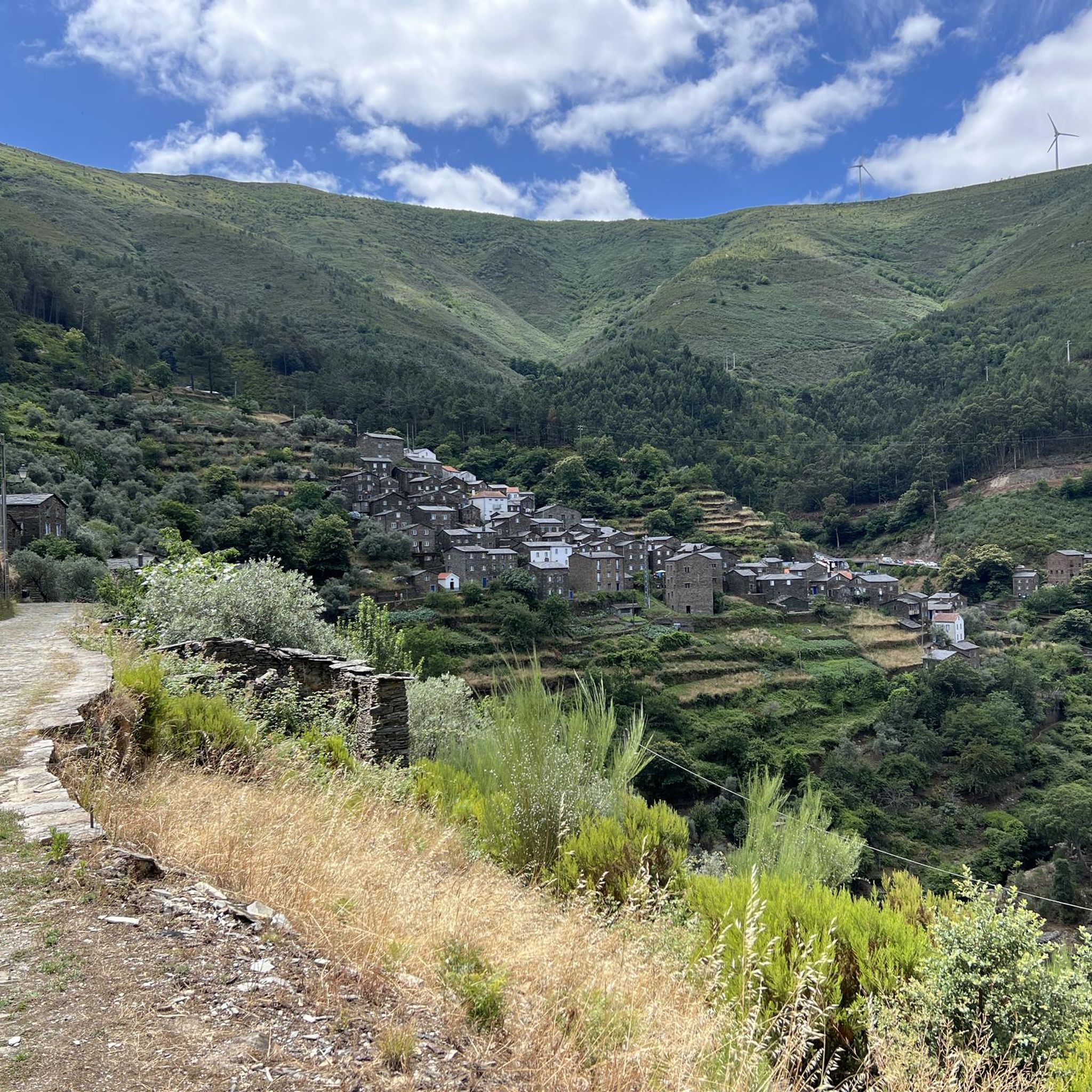
Piódão belongs to the network of Historic Villages of Portugal. The town (village) of Piódão, the urban center and the parish headquarters, has been classified as a Property of Public Interest since 1978.[3] Pedestrian trails of extraordinary beauty.👍🥾🦯
4
0

This area has been hit by a serious forest fire in recent weeks.
2
2

The church stands out in the village due to its contrast with the traditional houses. The interior altar is carved from gilded wood, and the walls are tiled. The mother church, dedicated to the Immaculate Conception, stands out from the small, two-story houses. Completely whitewashed and with its unique cylindrical buttresses, it was built by the locals in the 19th century using their own financial resources.
5
0
Piódão is a particularly well-preserved, historic village worth a visit. If you're looking for peace and quiet and enjoy hiking, you've come to the right place. Although the historic village of Piódão doesn't hold any particular significance in Portugal's history, it has recently become an increasingly popular tourist attraction, perhaps due to its beautiful location in the Serra do Açor.
5
2
It's not really a parking lot; parking is free along the street, but on some days it's hard to find a spot.
2
1
Nestled in the Serra do Açor Mountains, just 300 meters from Piódão, the hotel is integrated into the landscape of this slate village. The INATEL Piódão features 27 fully equipped rooms, a bar, a restaurant, a meeting room, a heated pool, a games room, Wi-Fi, and private parking. It offers stunning views of the historic village.
1
1
Frequently Asked Questions
How many hiking trails are available around Benfeita?
There are over 10 hiking trails around Benfeita, offering a range of experiences from easy strolls to more moderate adventures. The komoot community has explored these routes nearly 400 times, rating them highly for their natural beauty.
Are there easy hiking trails suitable for beginners in Benfeita?
Yes, Benfeita offers easy trails. For example, the Fraga da Pena Waterfall – Pardieiros Village loop from Serra do Açor Protected Landscape is an easy 2.5 km route that takes just under an hour to complete, perfect for a gentle introduction to the area's natural beauty.
Are there any trails that feature waterfalls in Benfeita?
Absolutely. The region is known for its waterfalls. The spectacular Fraga da Pena Waterfall is a must-see natural wonder, and you can explore it via the Fraga da Pena Waterfall – Pardieiros Village loop from Serra do Açor Protected Landscape. Many trails, including the local Benfeita Schist Trail, also follow streams with smaller cascades.
What kind of natural landscapes can I expect to see while hiking in Benfeita?
Benfeita is nestled within the Serra do Açor Protected Landscape, offering diverse natural beauty. You'll encounter deep river valleys, dense native forests like Mata da Margaraça (known as 'The Forest of Time'), and unique geological features. The trails often follow streams, leading to picturesque waterfalls and lush vegetation.
Are there any family-friendly hiking options in Benfeita?
Yes, several trails are suitable for families. The area features routes with moderate distances and elevation gains, allowing for enjoyable outings with children. The presence of river beaches and picnic spots, especially near waterfalls, adds to the family appeal.
Can I bring my dog on the hiking trails in Benfeita?
Most hiking trails in the Benfeita region are dog-friendly, allowing you to enjoy the natural surroundings with your canine companion. However, it's always advisable to keep dogs on a leash, especially in protected areas or near wildlife, and to respect local regulations.
Are there circular hiking routes available in Benfeita?
Yes, many of the trails around Benfeita are circular, allowing you to start and end your hike in the same location. An example is the Picnic Area – Eucalyptus Forest Trail loop from Serra do Açor Protected Landscape, which offers a comprehensive exploration of the protected area.
What interesting landmarks or attractions can I see near the hiking trails?
Beyond the natural beauty, you can explore several unique landmarks. The village of Benfeita itself is a charming 'schist village' with traditional architecture. Nearby, you can visit the Historical Village of Piódão, the river beach at Foz d'Égua, or the Chãs d'Égua Historical Village, all offering a glimpse into the region's heritage.
What is the best time of year to go hiking in Benfeita?
The Benfeita region is beautiful year-round, but spring (April-June) and autumn (September-October) are particularly pleasant for hiking. During these seasons, the weather is generally mild, and the landscapes are vibrant with spring blooms or autumn colors. Summers can be hot, making early morning or late afternoon hikes preferable, especially if you plan to cool off in the river beaches.
Is there parking available near the hiking trailheads in Benfeita?
Yes, parking is generally available in or near Benfeita village, as well as at popular trailheads and points of interest like the Fraga da Pena Waterfall. Look for designated parking areas, especially when starting a longer route.
What do other hikers enjoy most about hiking in Benfeita?
The area is highly rated by the komoot community, with an average score of 4.7 stars. Reviewers often praise the stunning natural beauty, the tranquility of the forests, the refreshing waterfalls, and the charm of the schist villages. Many appreciate the well-maintained paths and the diverse terrain that offers something for every hiker.
Are there any trails that lead to a secret waterfall or lagoon?
Yes, there is a trail specifically named for such a feature. The Picnic Area – Secret Waterfall and Lagoon loop from Benfeita is a moderate 6.6 km trail that takes you through riverine landscapes to discover hidden water features, typically completed in about 2 hours.
Most popular attractions around Benfeita

Get inspired with the komoot mobile app


Explore more
Browse the best Hikes in other regions.
