The best walks and hikes around Jeffersonville
4.6
(13)
275
hikers
11
hikes
Hiking around Jeffersonville, Indiana, offers diverse outdoor activities along the Ohio River and in nearby state parks. The region is characterized by its unique geographical location, featuring the Ohio River, exposed Devonian fossil beds, and varied habitats including wetlands and woodlands. Further afield, rugged hills, deep ravines, and karst sinkhole topography define areas like Charlestown State Park. Within the city, green spaces like Chapel Lake Park provide additional walking trails.
Best hiking trails around Jeffersonville
- The most popular hiking route…
Last updated: October 11, 2026
1
hikers
5.32km
01:50
400m
70m
Embark on the Long Trail to Round Top Shelter, a moderate hike that spans 3.3 miles (5.3 km) and climbs 1299 feet (396 metres). You can expect to complete this…
28.6km
07:22
150m
90m
Embark on a difficult hike along the Lamoille Valley Rail Trail from Jeffersonville to Morrisville, a substantial 17.8 miles (28.6 km) journey. You will gain 494 feet (151 metres) in…

1.01km
00:17
30m
10m
The Alden Bryan Brewster River Trail offers an easy hike through a peaceful hemlock forest, following the tranquil Brewster River. You will find beautiful views of the river as it…
1.59km
00:35
150m
0m
Embark on the Prospect Rock Trail, an easy hiking route that covers 1.0 miles (1.6 km) with a manageable elevation gain of 488 feet (149 metres). You can expect to…
10
hikers
4.72km
01:30
190m
190m
Embark on an easy hiking adventure to Prospect Rock via the Long Trail, a rewarding route that spans 2.9 miles (4.7 km) with a total elevation gain of 626 feet…
Get access to more routes and recommendations from other explorers.
Already have an account?
Our route recommendations are based on thousands of hikes, rides, and runs completed by other people on komoot.
Start today with a free account
Your next adventure awaits.

Tips from the Community

Great way to get up the Notch and avoid most of Route 107
0
0

Although the old railroad that the Lamoille Valley Rail Trail follows the path of is long gone, remnants like this old railroad bridge remain. It's a neat piece of history that you can ride over as you bike around the area.
0
0
Dog’s Head Falls is an attractive waterfall viewable from the Lamoille Valley Rail Trail near Johnson, Vermont. This is a great spot to ride to near the center of town or if exploring on the rail trail.
0
0
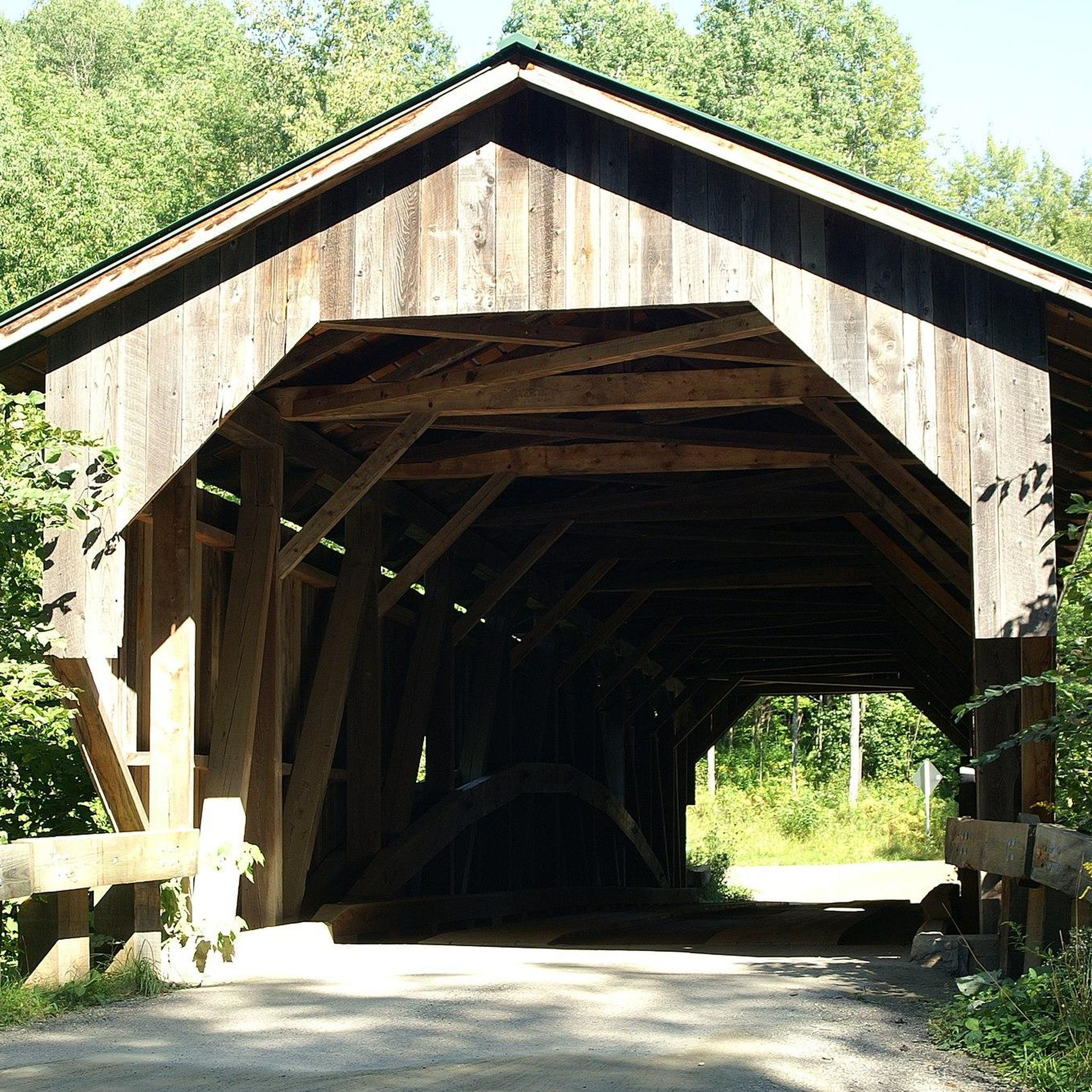
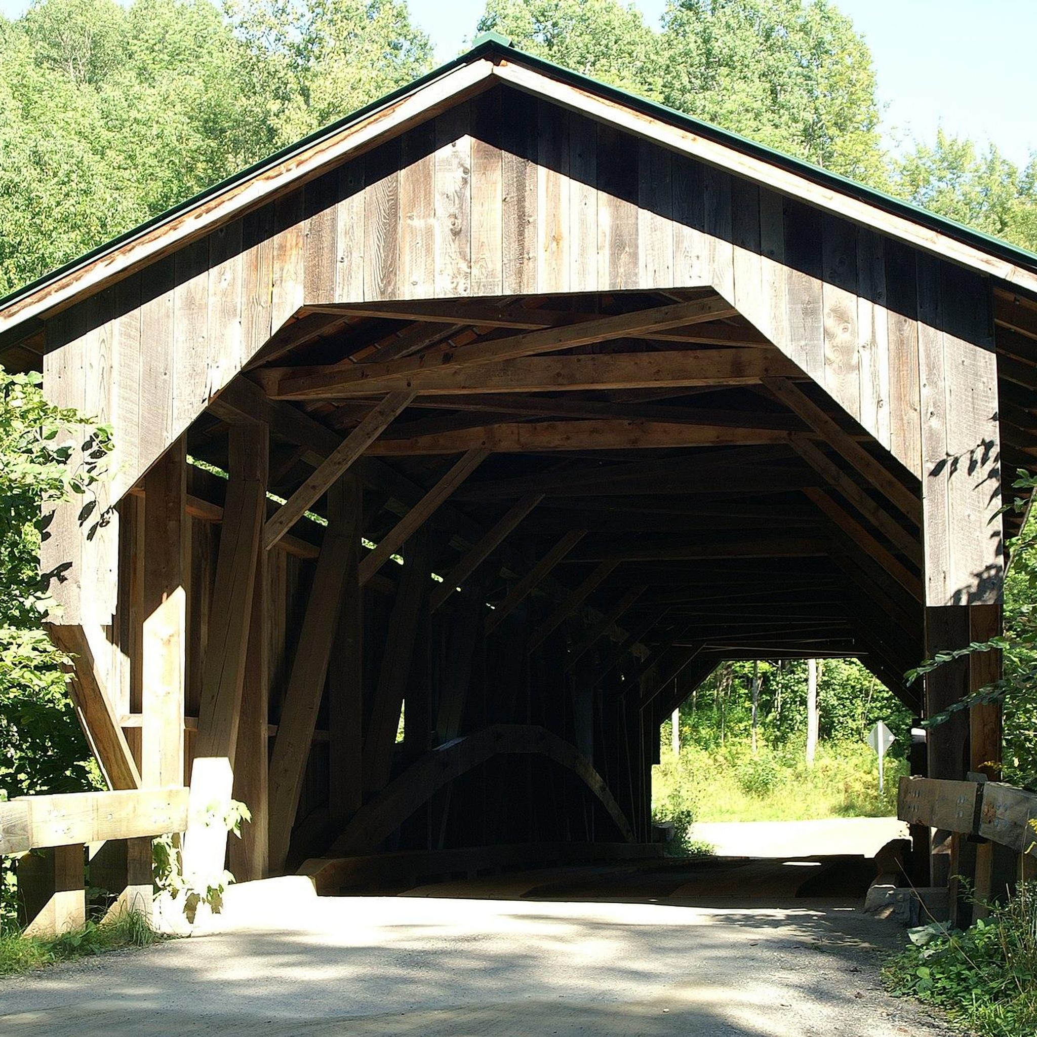
The Grist Mill Covered Bridge, which is also known as the Scott Covered Bridge, the Bryant Covered Bridge, or the Canyon Covered Bridge, spans the Brewster River near the beautiful Brewster River Gorge and falls. This bridge is one of a small number of surviving Burr arch truss bridges in the state and was built in the 19th century. In 1974 it was listed on the National Register of Historic Places. There is a nice overlook for the Brewster Falls not far from here, down a short trail if you wanted to leave your bikes and go on a short walk.
0
0
Down a short spur trail are the Brewster River Falls in Brewster River Gorge. This is a great spot to grab your camera and snap a few photographs of these beautiful falls before continuing on your hike.
0
0
From the main parking area, you must walk back on the road and through the Grist Mill Covered Bridge. Also known as the Scott Covered Bridge, the Bryant Covered Bridge,or the Canyon Covered Bridge, this bridge is one of a small number of surviving Burr arch truss bridges in the state and was built in the 19th century. In 1974 it was listed on the National Register of Historic Places.
0
0
Prospect Rock is a short, but steep, popular, family-friendly hike in the Lamoille Valley just north of Johnson, Vermont. One added benefit of this hike is that you travel along the famous Long Trail, a thru-hike that traverses the state of Vermont. This 2.6-mile round-trip hike begins by a short descent to a marsh before crossing a suspension bridge over the Lamoille River near Ithiel Falls before entering the woods. Once in the forest, you climb at a moderate grade until you hit a rock headwall. The trail begins to switchback steeply up the hillside before finally leveling off near the summit of Prospect Rock. From the flat bedrock overlook at the top, you get fantastic views of Lamoille River and the Sterling Range, making it a great spot to snap some photos and eat lunch.
0
0
Dog’s Head Falls is an attractive waterfall viewable from the Lamoille Valley Rail Trail near Johnson, Vermont. This is a great spot to walk to near the center of town or if exploring on the rail trail.
0
0
Frequently Asked Questions
What types of hiking trails can I expect to find around Jeffersonville?
Jeffersonville offers a diverse range of hiking experiences, from paved multi-use paths along the Ohio River to more rugged trails in state parks. You'll find riverfront paths, forested trails, and routes with scenic views of the surrounding hills and valleys. Options range from easy strolls to challenging long-distance hikes.
Are there any easy or family-friendly hiking options in Jeffersonville?
Yes, there are several easy and family-friendly options. The Alden Bryan Brewster River Trail is a short, easy walk through riverside landscapes. The Ohio River Greenway is a 7.5-mile paved path perfect for leisurely walks with continuous river access and views. Chapel Lake Park also features a 1.75-mile paved walking trail and additional grass trails suitable for families.
Where can I find trails with scenic river views?
For stunning river views, the Ohio River Greenway is an excellent choice, running along the banks of the Ohio River and offering continuous vistas. Additionally, within Charlestown State Park, Trail 6 (Riverview Overlook) provides rugged terrain with overlooks of the Ohio River and Twelvemile Island.
Are there any trails with waterfalls near Jeffersonville?
Yes, Charlestown State Park is known for its waterfalls. Trail 6 (Riverview Overlook) features a scenic waterfall, and Trail 2 leads to a seasonal waterfall. These are particularly impressive after rainfall.
What are some notable natural features or landmarks to look out for while hiking?
The region is rich in natural and historical landmarks. The Falls of the Ohio State Park features the world's largest exposed Devonian fossil beds. The Big Four Bridge offers panoramic views of the Ohio River and Louisville skyline. Charlestown State Park showcases rugged hills, deep ravines, and karst sinkhole topography.
Can I bring my dog on the hiking trails around Jeffersonville?
Many trails in the Jeffersonville area are dog-friendly, especially those in state parks and multi-use paths like the Ohio River Greenway. However, it's always best to check specific park regulations before you go, and ensure your dog is on a leash and you clean up after them.
What is the best time of year to go hiking in Jeffersonville?
The spring and fall seasons are generally ideal for hiking in Jeffersonville. Spring brings blooming wildflowers and comfortable temperatures, while fall offers vibrant foliage. Summer can be warm and humid, but shaded trails are still enjoyable. Winter hiking is possible, but some trails may be slick or muddy.
Are there any longer or more challenging hikes available?
For a more challenging experience, consider the Lamoille Valley Rail Trail: Jeffersonville to Morrisville, a difficult 17.8-mile path following a former railway line. Charlestown State Park also offers over 13 miles of marked trails, with options ranging from moderate to rugged, allowing for longer treks by combining routes.
What do other hikers say about the trails in Jeffersonville?
The hiking routes in Jeffersonville are highly rated by the komoot community, with an average score of 4.3 stars from over 10 reviews. Hikers often praise the varied terrain, from riverfront paths to forested climbs, and the opportunities for scenic views.
Are there any trails that offer a good workout with elevation gain?
Yes, for a good workout, the Long Trail to Round Top Shelter is a moderate 3.3-mile trail that features a steady climb through varied terrain, offering a noticeable elevation gain.
Where can I find trails for birdwatching or wildlife spotting?
The Falls of the Ohio State Park, with its diverse habitats including wetlands and woodlands, is an excellent spot for birdwatching. Charlestown State Park also provides opportunities for observing diverse bird species and other wildlife due to its rugged and varied landscape.
Are there any paved walking trails suitable for strollers or wheelchairs?
The Ohio River Greenway is a 7.5-mile multi-use paved path that is generally suitable for strollers and wheelchairs, offering continuous river access. Chapel Lake Park also features a 1.75-mile paved walking trail that is accessible.
Most popular routes around Jeffersonville
Most popular attractions around Jeffersonville

Get inspired with the komoot mobile app


Explore more
Browse the best Hikes in other regions.
