The best road cycling routes around Marble Cliff
4.8
(67)
1,233
riders
50
rides
Road cycling routes around Marble Cliff primarily follow the Olentangy and Scioto River corridors, offering generally flat to gently undulating terrain. The area features established multi-use paths and roads that connect urban green spaces and natural riverine landscapes. Elevation gains are typically low, making the region suitable for various fitness levels. These routes often provide views of the rivers and access to local parks.
Best road cycling routes around Marble Cliff
- The most popular road cycling route is Olentangy River…
Last updated: July 2, 2026
4.8
(12)
160
riders
Easy road ride. Great for any fitness level. Mostly well-paved surfaces and easy to ride.
4.0
(2)
74
riders
53.6km
02:13
180m
180m
Moderate road ride. Good fitness required. Mostly well-paved surfaces and easy to ride.

Sign up for free
5.0
(1)
65
riders
Moderate road ride. Good fitness required. Mostly well-paved surfaces and easy to ride.
4.0
(2)
40
riders
60.5km
02:24
190m
190m
Moderate road ride. Good fitness required. Mostly well-paved surfaces and easy to ride.
5.0
(12)
40
riders
Easy road ride. Great for any fitness level. Mostly well-paved surfaces and easy to ride.
Get access to more routes and recommendations from other explorers.
Sign up for free
Already have an account?
Our route recommendations are based on thousands of hikes, rides, and runs completed by other people on komoot.
Start today with a free account
Your next adventure awaits.
Login or Signup
Popular around Marble Cliff


Tips from the Community

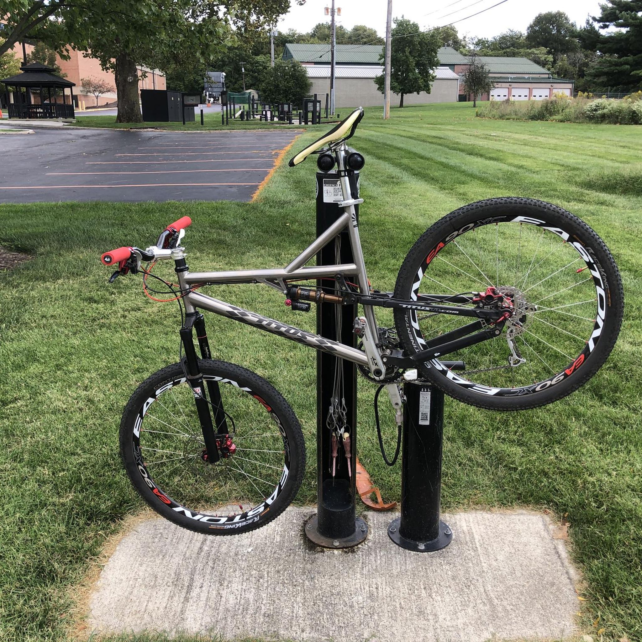
You’ll find this convenient bike repair station along the Scioto Trail, with a pump and tools available.
1
0

The Olentangy Trail extends from Worthington to the heart of Columbus, tracing the scenic route along the Olentangy River. This trail meanders through popular parks, recreational facilities, and preserved natural spaces.
0
0

With the sparkling water in front of you and the city skyline in the background, this is a great place to stop and take in the view. It's especially great on calm, clear nights when the city lights reflect of the water.
0
0

Big Darby Creek, not to be confused with Little Darby Creek, is a scenic river. It is one of the most biologically diverse rivers in the Midwest. It is 84 miles long and empties into the Scioto River.
0
0

Wilson Road Park, a 47.5-acre regional park in the Hilltop community, offers an easy access point to the Camp Chase Trail and over 125 miles of regional trails, including the Ohio to Erie Trail. Built in 2017, the park features athletic fields, a paved path, an open-air shelter with picnic tables, bike racks, a water fountain, and a bike-repair station, making it a popular stop for cyclists, walkers, and runners.
0
0
The Olentangy River reaches 97 miles from Morrow County through Delaware County to Columbus, where it meets the Scioto at Confluence Park. Originally called "Keenhongsheconsepung," meaning "sharp tool river," settlers renamed it "Whetstone River" before a legislative mix-up in 1833 assigned it the name "Olentangy." The river serves as a drinking water source for Delaware County, while the Delaware State Park Reservoir is used for flood control. Restoration efforts, including dam removals, have reduced the river’s width and improved ecology.
0
0
The Camp Chase Trail is a 16-mile rail trail connecting Madison County to Columbus, Ohio, and forms part of the Ohio to Erie Trail and U.S. Bicycle Route 50. Starting at the Wilson Road SE trailhead, it changes from rural farmlands and prairies to urban landscapes, with highlights like Battelle Darby Creek Metro Park with its bison herd and the historical Fort Ancient mound. This ADA-compliant trail provides opportunities for walking, biking, and cross-country skiing in winter.
0
0

This 22-mile trail is one of the most important cycling routes in Columbus, connecting neighborhoods and Ohio State University to some of the city's best attractions: Natural areas, historical sites, cultural areas, and more.
0
0
Frequently Asked Questions
How many road cycling routes are available around Marble Cliff?
There are over 45 road cycling routes around Marble Cliff, offering a variety of options for different skill levels and preferences. The komoot community has explored these routes extensively, with over 600 road cyclists using komoot to navigate the area.
What is the general terrain like for road cycling in Marble Cliff?
Road cycling routes around Marble Cliff primarily follow the Olentangy and Scioto River corridors. The terrain is generally flat to gently undulating, with low elevation gains. This makes the region suitable for a wide range of fitness levels, from casual riders to those looking for longer, moderate distances.
Are there easy or beginner-friendly road cycling routes in Marble Cliff?
Yes, Marble Cliff offers many easy road cycling routes. Approximately 29 of the routes are classified as easy, making them ideal for beginners or those seeking a relaxed ride. An excellent option is the Olentangy River Trail – Antrim Lake Deck loop from The Ohio State University, an easy 25.3-mile route.
Are there options for longer distance road cycling in the Marble Cliff area?
Absolutely. For those looking for longer rides, Marble Cliff offers several moderate routes that connect major river trails. The Scioto River Bridge – Camp Chase Trail loop from The Ohio State University is a notable option, covering 48.6 miles and leading through riverfront areas.
What kind of scenic views can I expect while road cycling in Marble Cliff?
The routes in Marble Cliff often provide scenic views of the Olentangy and Scioto Rivers. You'll also encounter urban green spaces and natural riverine landscapes. Notable attractions along the way include the Olentangy River itself, the Scioto River Bridge, and the Scioto Audubon Metro Park.
Are there any interesting landmarks or points of interest along the road cycling routes?
Yes, several interesting landmarks are accessible from the road cycling routes. You might pass by the iconic Ohio Stadium, the Scioto River Bridge, and the Historic Columbus Union Station Arch. These routes often connect urban parks and historical sites.
What do other road cyclists enjoy most about cycling in Marble Cliff?
The road cycling experience in Marble Cliff is highly rated by the komoot community, with an average score of 4.5 stars from over 29 reviews. Cyclists often praise the well-maintained multi-use paths, the scenic river corridors, and the accessibility of routes that connect urban green spaces.
Are there circular road cycling routes available?
Many of the road cycling routes around Marble Cliff are designed as loops, offering convenient circular journeys. Examples include the Olentangy River – Scioto River Bridge loop from The Ohio State University and the Scioto Audubon Metro Park – Olentangy River loop from Upper Arlington, allowing you to start and finish at the same point.
Is Marble Cliff suitable for family-friendly road cycling?
Given the generally flat terrain and the prevalence of established multi-use paths along the river corridors, Marble Cliff is well-suited for family-friendly road cycling. The numerous easy routes, such as the Olentangy Trail – Olentangy River loop from Upper Arlington, provide a safe and enjoyable environment for riders of all ages.
When is the best time of year for road biking in Marble Cliff?
While specific data isn't available, the best time for road biking in Marble Cliff generally aligns with typical cycling seasons. Spring and fall offer pleasant temperatures and vibrant scenery. Summer can also be enjoyable, especially along the shaded river trails, though it's advisable to ride earlier in the morning or later in the afternoon to avoid peak heat.
Are there any challenging road cycling routes in the Marble Cliff area?
The road cycling routes around Marble Cliff are generally characterized by low elevation gains and flat to gently undulating terrain. While there are longer, moderate routes that require more endurance, there are no routes classified as 'difficult' in terms of significant climbs or technical challenges. The focus is more on scenic, accessible rides.
Most popular routes around Marble Cliff
Most popular attractions around Marble Cliff

Get inspired with the komoot mobile app


Explore more
Browse the best Road cycling routes in other regions.
