The best walks and hikes around Furnace Creek
4.8
(198)
2,553
hikers
31
hikes
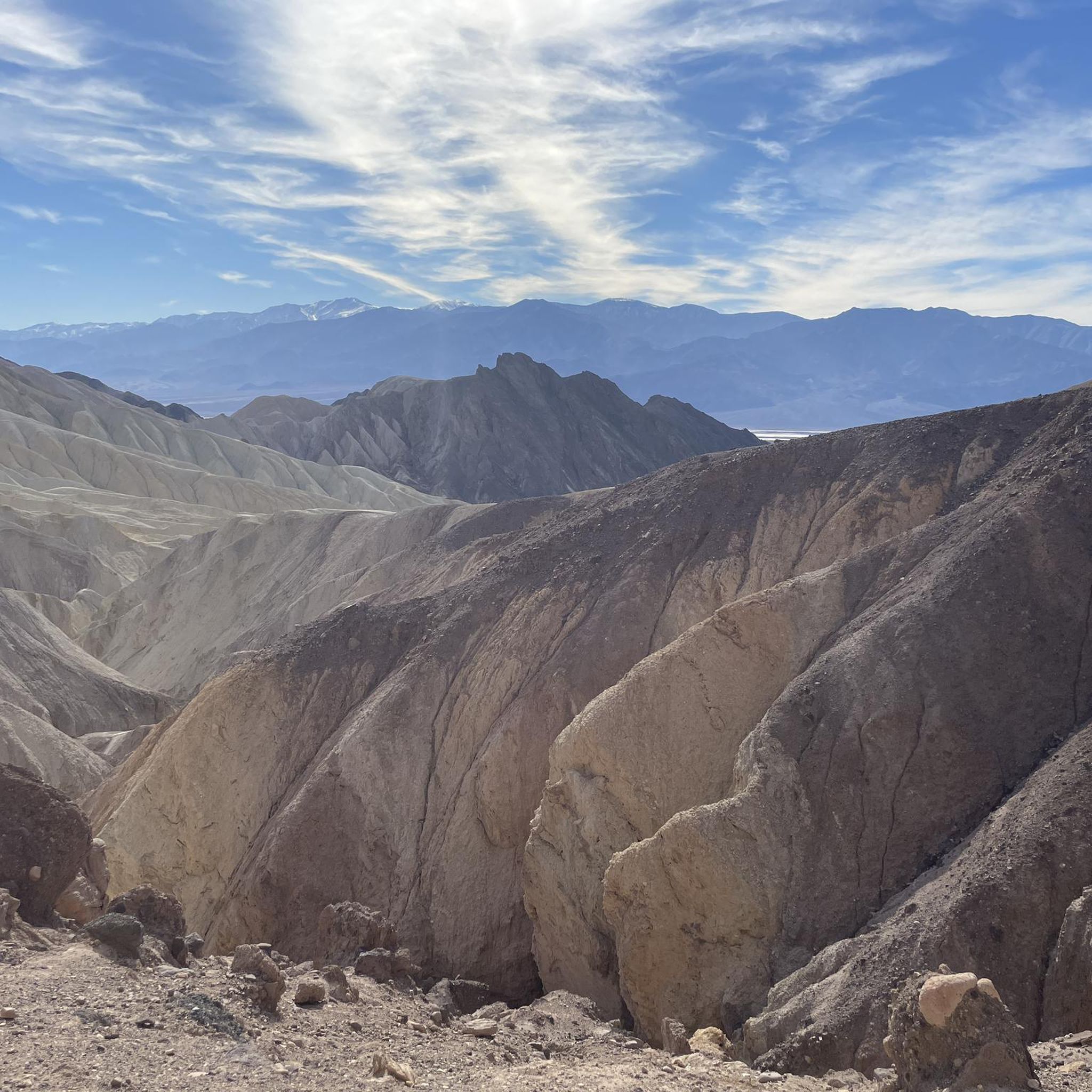
Hiking around Furnace Creek, located in Death Valley National Park, offers access to a unique and diverse desert landscape. The region is characterized by expansive salt flats, vibrantly colored badlands, towering sand dunes, and dramatic canyons. Hikers can explore geological formations, historical sites, and varied terrain, providing a distinct outdoor experience in one of the world's most extreme environments.
Best hiking trails in Furnace Creek
- The most popular hiking route is Golden Canyon & Gower Gulch loop from Zabriskie Point — Death Valley National Park, a 6.0 miles (9.7 km) moderate trail that takes 2 hours 52 minutes to complete. This loop features colorful rock formations and badlands scenery.
- Another top favourite among local hikers is Golden Canyon Trail to Red Cathedral via Gower Gulch Loop — Death Valley National Park, a moderate 5.1 miles (8.2 km) path. This route leads through golden badlands and offers views of the crimson cliffs of Red Cathedral.
- Local hikers also love the Zabriskie Point — Death Valley National Park, a 1.3 miles (2.0 km) trail leading through eroded hills and mountains, often completed in about 34 minutes.
- Hiking around Furnace Creek is defined by salt flats, badlands, sand dunes, and canyons. The network offers options for various ability levels, from short, easy walks to longer, moderate loops.
- The routes in Furnace Creek are highly rated by the komoot community with an average score of 4.8 stars from more than 160 reviews. More than 1900 hikers have used komoot to explore Furnace Creek's varied terrain.
Last updated: September 27, 2026
4.9
(81)
670
hikers
9.69km
02:52
290m
290m
The Golden Canyon and Gower Gulch Loop Trail offers a captivating journey through Death Valley's unique badlands, showcasing a dramatic shift in scenery from wide, golden-walled canyons to rugged gulches. You'll start with a gradual climb through Golden Canyon, navigating minor rock scrambles and enjoying the vibrant geological layers, with the option to detour to the impressive Red Cathedral. The route then ascends towards Manly Beacon for panoramic views before descending through the gravel-filled Gower Gulch, which features narrow sections and rocky dry waterfalls.
This moderate 6.0-mile (9.7 km) hike, with 946 feet (288 metres) of elevation gain, typically takes around 2 hours and 51 minutes. For the best experience, plan your visit for just after sunrise or right before sunset, when cooler temperatures and optimal lighting enhance the colorful landscape. The trailhead is easily accessible, but always carry ample water, as conditions in Death Valley can be extreme.
What makes this loop truly stand out is its accessibility and the sheer diversity of terrain and color packed into a single outing. It's considered one of the best day hikes in Death Valley National Park, moving from the striking golden hues of the canyon to the more rugged, water-carved features of the gulch. While the Golden Canyon section can be busy, the full loop often provides a more secluded experience, making it a rewarding choice for those seeking iconic desert geology.
4.5
(11)
88
hikers
3.36km
00:59
110m
70m
The Badlands Loop offers a captivating journey through Death Valley's unique terrain, showcasing a lunar-like landscape of striated barren geology. You'll encounter fantastic views of classic rock formations, including jagged buttes and spires, particularly around the Viewpoint and Zabriskie Point. This easy 2.1-mile (3.4 km) hiking route, with 375 feet (114 metres) of elevation gain, is a perfect introduction to the park's dramatic scenery, taking just under an hour to complete.
Planning your visit is straightforward, as the trailhead is conveniently located near Zabriskie Point, a well-known spot with parking. Given the consistent lack of shade, it's crucial to bring plenty of water and wear sun protection, especially during warmer periods. For the most comfortable experience, aim to hike in the cooler mornings or late afternoons. No special permits are needed for this accessible trail.
This area is a geological time capsule, revealing millions of years of erosion through its colorful spires and pinnacles. The Badlands Loop is a great way to experience the park's diverse scenery, from these striking formations to distant views of the White River Valley. It's an excellent choice for families or anyone looking for a high-reward, low-effort hike in Badlands National Park.

5.0
(44)
354
hikers
8.19km
02:26
240m
250m
Embark on the Golden Canyon and Gower Gulch Loop Trail for a moderate hike through Death Valley's striking desert scenery. This 5.1 miles (8.2 km) route takes about 2 hours and 25 minutes to complete, with an elevation gain of 775 feet (236 metres). You will experience a dramatic shift from the narrow, towering golden walls of Golden Canyon to the colorful, otherworldly badlands, revealing unique geological formations as you go.
When planning your visit, consider hiking this loop in a clockwise direction. This approach helps you tackle most of the climbing early on, making the ascent more manageable. Parking is conveniently available at the Golden Canyon trailhead, which serves as the starting point for this engaging desert adventure. Always check park conditions before you head out.
This trail is particularly notable for its diverse geology, showcasing how the landscape changes from deep canyons to expansive washes. You can also take a short spur trail to see the Red Cathedral, a vibrant, fire-colored formation that stands out against the desert backdrop. The return journey through Gower Gulch offers wider views and different rock textures, making the entire loop a comprehensive tour of the area's natural wonders.
1
hikers
3.53km
01:08
210m
40m
Embark on an easy hiking adventure through the Golden Canyon, Gower Gulch, and Badlands Loop, a 2.2-mile (3.5 km) route that offers a unique glimpse into Death Valley's striking geology. You will gain 673 feet (205 metres) in elevation over approximately 1 hour and 7 minutes, traversing deep corridors with towering golden walls before emerging into an alien-like landscape. The trail provides panoramic views, including the prominent Manly Beacon, and winds through the multicolored formations of Gower Gulch.
When planning your visit, remember that this trail has very little shade, so it is best to hike during the cooler winter months. Aim for early morning or late afternoon to avoid the harshest sun. Always carry adequate water to stay hydrated and use sun protection, such as a hat and sunscreen. Be prepared for some minor rock scrambling over short ledges in certain sections of the route.
This loop offers a fascinating journey through Death Valley's distinctive geological features, showcasing its chalky yellow badlands and unique rock formations. As you explore, you might even discover remnants of old borax mines, adding a historical layer to your outdoor experience. The trail's diverse scenery and accessible difficulty make it a notable option for understanding the region's natural and industrial past.
1
hikers
679m
00:13
50m
0m
Embark on an easy hike along the Golden Canyon Trail, a short but captivating route that winds through dramatic desert scenery. This 0.4-mile (0.7 km) path takes you past towering, yellow-hued canyon walls, revealing ancient ripple marks preserved in stone. You will gain 148 feet (45 metres) in elevation, and the entire experience typically takes around 12 minutes, offering a quick yet immersive journey into Death Valley's unique landscape.
When planning your visit, consider hiking during spring or fall for more comfortable temperatures. It is best to avoid the trail after 10 AM in summer due to extreme heat. Parking can fill up quickly, so arriving early is advisable to secure a spot. Remember to bring plenty of water and sun protection, as facilities are limited, and note that pets are not permitted on the trail.
The Golden Canyon Trail is particularly notable for its striking geological features, showcasing the incredible yellow and golden coloration of the canyon walls, a result of limonite. A highlight of the route is reaching the Red Cathedral, a stunning rock formation with vertically fluted, fire-colored red walls that provide a dramatic contrast to the surrounding golden hues. This trail offers a glimpse into the park's ancient past, with geological formations telling tales of a former lake.
Get access to more routes and recommendations from other explorers.
Already have an account?
Our route recommendations are based on thousands of hikes, rides, and runs completed by other people on komoot.
Start today with a free account
Your next adventure awaits.
Popular around Furnace Creek
Tips from the Community

The heat should not be underestimated… Despite the short distance
1
0


This is one of the famous viewpoints of the park. It is surrounded by wild, sandy, barren mountains.
4
1

Zabriskie Point is a lookout point in the Amargosa Range in Death Valley National Park, known for its bizarre erosion landscapes around the former Lake Manly. It was named at the beginning of the 20th century after Christian Brevoort Zabriskie from Wyoming, the vice president and general manager of the Pacific Coast Borax Company, which was commissioned to mine borax in the area.
3
0

The Red Cathedral is a crimson cliff that stands out 183 meters above and behind the yellow and brown slopes and walls of the Golden Canyon. The origin of the name comes from the red rocks that have eroded into pillars in some places
0
0

The cover of the legendary U2 album "The Joshua Tree" was recorded here. The cover's tree was on the edge of the national park on Route 190 (a construction site in the winter of 2023), but has now died.
2
1
Iconic photo spot where the cover of the U2 album "The Josuha Tree" was photographed by Anton Corbijn.
3
0
Frequently Asked Questions
How many hiking trails are available around Furnace Creek?
Furnace Creek offers a diverse selection of over 20 hiking routes. These trails cater to various skill levels, with 15 routes considered easy, 4 moderate, and 1 difficult, ensuring options for every hiker.
What is the best time of year to hike in Furnace Creek?
The ideal time for hiking in Furnace Creek is during the cooler months, typically from October to April. During this period, temperatures are more moderate, making exploration of Death Valley's unique landscapes much more comfortable. Summer months bring extreme heat, which can be hazardous for hiking.
Are there any easy or beginner-friendly hikes in Furnace Creek?
Yes, Furnace Creek has many easy trails suitable for beginners. For instance, the Zabriskie Point — Death Valley National Park trail is a short 1.3-mile (2.0 km) walk through eroded hills, often completed in under an hour. Another accessible option is the Golden Canyon Trail – Upper Golden Canyon Trail loop from Snow Mountain, which is 3.3 miles (5.3 km) and rated easy.
Can I find family-friendly hiking options near Furnace Creek?
Absolutely. Many of the 15 easy routes around Furnace Creek are suitable for families. The short walk to Zabriskie Point offers stunning views with minimal effort. The boardwalk trail at Salt Creek is also a great family option, providing a chance to see the unique pupfish, especially between November and May.
Are there any circular hiking routes in Furnace Creek?
Yes, several trails around Furnace Creek are designed as loops. A popular moderate option is the Golden Canyon & Gower Gulch loop from Zabriskie Point, which is 6.0 miles (9.7 km) and features colorful rock formations. Another loop is the Zabriskie Point – Badlands Loop in Gower Gulch loop from Snow Mountain, an easy 2.6-mile (4.2 km) route.
What kind of terrain can I expect on hikes around Furnace Creek?
Hiking terrain around Furnace Creek is incredibly diverse and unique. You'll encounter expansive salt flats at Badwater Basin, vibrantly colored badlands and eroded hills at Zabriskie Point, towering Mesquite Flat Sand Dunes, and dramatic canyons like Golden Canyon. The trails often feature loose gravel, packed earth, and rocky sections.
Are there any dog-friendly trails in Furnace Creek?
Death Valley National Park has specific regulations regarding pets. Generally, pets are not permitted on hiking trails, unpaved roads, or in wilderness areas. They are allowed on paved roads, in campgrounds, and at developed areas. Always check the latest park regulations before bringing your pet. For more detailed information, you can visit the official NPS website: nps.gov/deva/planyourvisit/hiking.htm.
What interesting natural features or landmarks can I see while hiking?
Furnace Creek is surrounded by remarkable natural features. You can explore the colorful badlands of Golden Canyon, witness the crimson cliffs of Red Cathedral, or marvel at the panoramic views from Zabriskie Point. Other notable sights include the vast salt flats of Badwater Basin, the impressive Mesquite Flat Sand Dunes, and the unique Natural Bridge rock formation.
Is parking available at trailheads in Furnace Creek?
Yes, most popular trailheads and viewpoints around Furnace Creek, such as Zabriskie Point, Golden Canyon, and Badwater Basin, have designated parking areas. These are typically well-marked and provide access to the trail systems. It's always advisable to arrive early during peak season to secure a spot.
What do other hikers say about the trails in Furnace Creek?
The hiking routes around Furnace Creek are highly regarded by the komoot community, boasting an average rating of 4.8 stars from over 160 reviews. Hikers frequently praise the unique and 'otherworldly' landscapes, the dramatic geological formations, and the stunning views, especially at sunrise and sunset.
Are there any historical sites I can visit on a hike?
Yes, you can combine hiking with a visit to historical sites. The Harmony Borax Works is a significant historical site near Furnace Creek, offering a glimpse into the region's mining past. A short, paved trail explains the story of borax mining and the famous Twenty Mule Teams.
Do I need a permit to hike in Death Valley National Park?
While you don't typically need a specific hiking permit for day hikes in Death Valley National Park, there is an entrance fee to access the park. This fee can be paid at visitor centers or automated fee machines. For the most current information on fees and any specific permit requirements for backcountry or overnight trips, please consult the official National Park Service website: nps.gov/deva/planyourvisit/hiking.htm.
What are some unique natural phenomena I might encounter?
Furnace Creek offers several unique natural phenomena. You can walk on the vast, surreal salt polygons of Badwater Basin, the lowest point in North America. The Mesquite Flat Sand Dunes provide an ever-changing landscape. Additionally, the Salt Creek pupfish, an endemic species, can be observed in Salt Creek, particularly when water flows between November and May.
Most popular routes around Furnace Creek
Most popular attractions around Furnace Creek

Get inspired with the komoot mobile app


Explore more
Browse the best Hikes in other regions.
