The best walks and hikes in Dallas County
4.4
(11)
119
hikers
27
hikes
Hiking in Dallas County offers diverse outdoor experiences, characterized by extensive greenbelts, urban wilderness areas, and remnants of the Blackland Prairie ecosystem. The region features the Trinity River Corridor, providing miles of trails through urban hardwood forests, and significant natural features like White Rock Lake. Numerous creeks and their wooded banks, such as those found near Cedar Ridge Preserve, contribute to varied terrain with occasional elevation changes. This landscape provides opportunities to explore varied natural features within an urban setting.
…Last updated: October 10, 2026
2
hikers
6.12km
01:35
30m
40m
Easy hike. Great for any fitness level. Easily-accessible paths. Suitable for all skill levels.
1.60km
00:25
10m
20m
Easy hike. Great for any fitness level. Easily-accessible paths. Suitable for all skill levels.

20.5km
05:15
80m
90m
Hard hike. Very good fitness required. Easily-accessible paths. Suitable for all skill levels.
1.60km
00:25
10m
20m
Easy hike. Great for any fitness level. Easily-accessible paths. Suitable for all skill levels.
6.03km
01:36
60m
60m
Easy hike. Great for any fitness level. Easily-accessible paths. Suitable for all skill levels.
739m
00:11
0m
0m
Easy hike. Great for any fitness level. Easily-accessible paths. Suitable for all skill levels.
597m
00:09
0m
0m
Easy hike. Great for any fitness level. Easily-accessible paths. Suitable for all skill levels.
3.0
(1)
2
hikers
8.82km
02:19
70m
70m
Moderate hike. Good fitness required. Easily-accessible paths. Suitable for all skill levels.
4.0
(2)
30
hikers
Easy hike. Great for any fitness level. Easily-accessible paths. Suitable for all skill levels.
5.0
(1)
13
hikers
5.35km
01:25
50m
50m
Easy hike. Great for any fitness level. Easily-accessible paths. Suitable for all skill levels.
Get access to more routes and recommendations from other explorers.
Already have an account?
Our route recommendations are based on thousands of hikes, rides, and runs completed by other people on komoot.
Start today with a free account
Your next adventure awaits.



Tips from the Community

A small park behind the police station. It links up to a historic mine entrance and a parking lot for people to hop on the trail next to the bridge. There are a lot of stairs, so try the other side of the bridge instead if needed. the park features some equipment for children, a gazebo, and water hydrant. But be careful, it's a gusher.
0
0
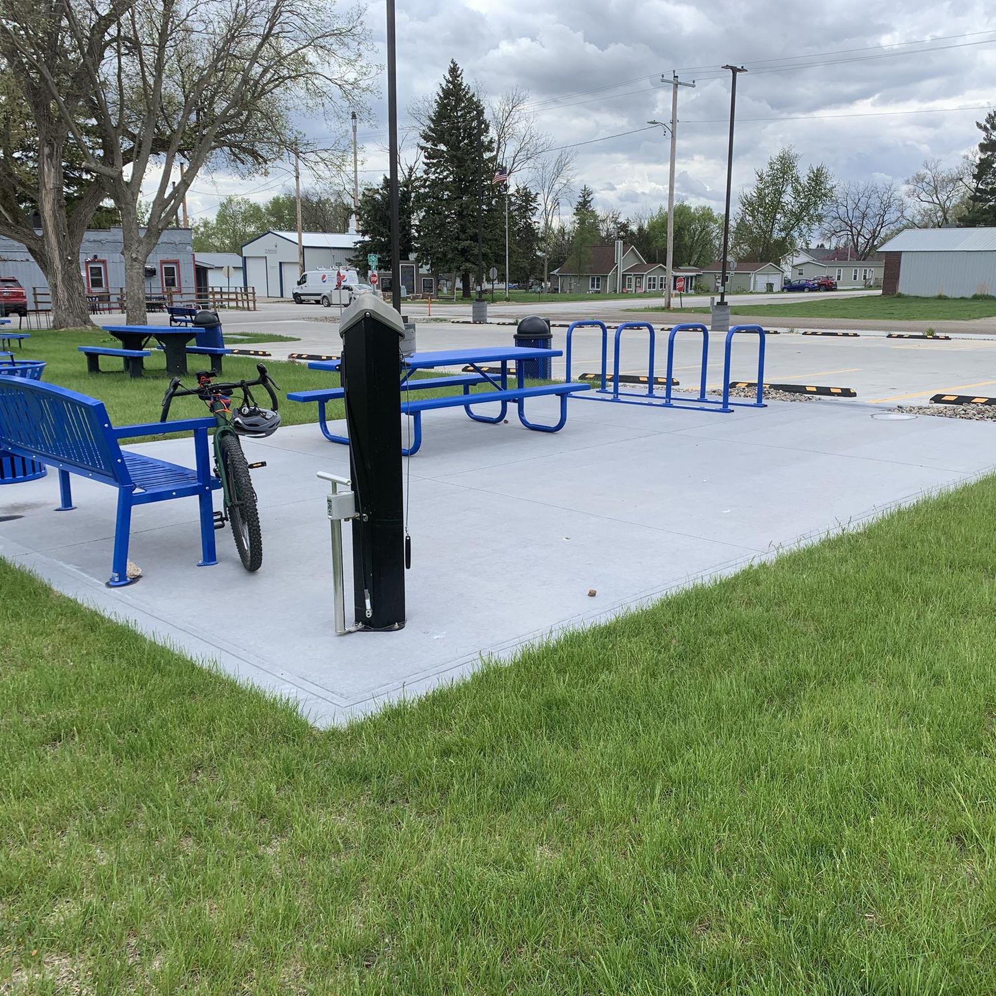
Bike maintenance area (including tools and air pump) and shelter right next to viewing area.
0
0
The Woodward Trailhead is part of the High Trestle Trail (HTT) that links to several multi-use pathways throughout central Iowa. Woodward boasts an adorable street sign to promote local businesses, restrooms, water fountains, parking lot, swing sets, a free little library, and a “story time” segment along the trail sponsored by the local library.
1
0


The High Trestle Trail Bridge is one of the most well-known rail to trail art installations. It's 130 feet tall and wrapped in 43 twisting steel ribs that are lined with LED lights.
1
0

A converted portion of an early-1900s-era railroad bridge overlooks the modern bridge, the Des Moines River, and the surrounding farmland. There are restrooms nearby.
0
0
The High Trestle Trail Bridge crosses the Des Moines River and is known for its distinctive architecture. There is a covered picnic shelter located at the east end of the bridge.
1
0

The High Trestle Trail Bridge is a 1/2 mile long, 13-story high bridge that spans the Des Moines River Valley. It is one of the largest trail bridges in the world. This bridge has received many awards and was listed as one of the BBC's "eight amazing footbridges" in 2015 (https://www.bbc.com/culture/article/20150401-eight-amazing-footbridges)
3
0
Frequently Asked Questions
How many hiking trails are available in Dallas County?
Dallas County offers a diverse selection of over 15 hiking routes, catering to various skill levels. You'll find everything from easy strolls to more moderate paths through its urban green spaces and natural areas.
What kind of terrain can I expect on Dallas County hiking trails?
Hiking in Dallas County features a mix of urban wilderness, extensive greenbelts, and remnants of the Blackland Prairie ecosystem. You'll encounter trails along the Trinity River Corridor, through urban hardwood forests, and around significant natural features like White Rock Lake. Some areas, particularly around creeks and places like Cedar Ridge Preserve, offer more varied terrain with noticeable elevation changes.
Are there easy hiking trails suitable for beginners in Dallas County?
Yes, Dallas County has many easy trails. Out of the 17 routes, 13 are classified as easy. An example is the North Loop — Brown's Woods — West Des Moines, an easy 3.1-mile trail that winds through wooded areas.
Are there any more challenging hiking options in Dallas County?
While most trails are easy, there are moderate options for those seeking a bit more challenge. For instance, the High Trestle Trail — Boone County, Iowa is a moderate 5.5-mile path offering scenic views. Additionally, areas like Cedar Ridge Preserve are known for their rugged trails and significant elevation changes, providing a more demanding experience.
What natural features or landmarks can I see while hiking in Dallas County?
Dallas County's trails often lead through the Trinity River Corridor, offering views of the Trinity Forest, one of the largest urban hardwood forests. You can also explore areas like White Rock Lake, a popular hub for outdoor recreation. Some trails may pass by remnants of the Blackland Prairie ecosystem or offer views of creeks and their wooded banks. For specific points of interest, highlights like the Woodward Trailhead – High Trestle Trail are notable.
Are there family-friendly hiking trails in Dallas County?
Many of Dallas County's trails are suitable for families, especially the numerous easy routes. Parks like Kiest Park offer accessible options, and the extensive network of trails along the Trinity River provides opportunities for enjoyable walks with children. The diverse urban green spaces ensure there are paths for all ages.
Are dog-friendly hiking trails available in Dallas County?
Yes, many parks and trails in Dallas County welcome dogs, typically requiring them to be on a leash. The extensive trail systems, including those along the Trinity River and in various city parks, provide ample opportunities for you and your canine companion to enjoy the outdoors together. Always check specific park regulations before you go.
Are there circular hiking routes in Dallas County?
Yes, you can find several circular hiking routes. An example is the Walnut Creek Trail to Denman's Woods loop — Des Moines, an 8.4-mile trail that takes you through varied natural landscapes. Another option is the Brown's Woods loop from Brown's Woods.
What do other hikers enjoy most about trails in Dallas County?
The trails in Dallas County are highly rated by the komoot community, with an average score of 4.4 stars from 10 reviews. Hikers often praise the accessibility of urban green spaces, the variety of terrain from wooded areas to lake views, and the opportunity to experience nature within the city.
Is parking generally available at Dallas County trailheads?
Yes, most major parks and trailheads in Dallas County, such as Cedar Ridge Preserve, Harry Moss Park, and those around White Rock Lake, offer dedicated parking facilities. While some popular spots can fill up during peak times, parking is generally accessible for hikers.
Can I reach hiking trails in Dallas County using public transport?
Dallas County's DART (Dallas Area Rapid Transit) system provides access to many areas, and some trailheads or parks are within reasonable walking distance of bus or light rail stops. For example, trails around White Rock Lake are relatively accessible. It's advisable to check specific routes and schedules for the trailhead you plan to visit.
What is the best time of year to hike in Dallas County?
The best times to hike in Dallas County are typically spring (March to May) and fall (September to November). During these seasons, temperatures are milder and more comfortable for outdoor activities. Summer can be very hot and humid, while winter generally offers pleasant, cooler days, though occasional cold snaps can occur.
Are there any trails that offer a unique urban wilderness experience?
Absolutely. The Trinity River Corridor is a prime example, offering an extensive network of trails through the Trinity Forest, one of the largest urban hardwood forests in the U.S. This area provides a unique blend of natural immersion within an urban setting, allowing you to spot wildlife and enjoy diverse ecosystems close to the city.
Most popular attractions in Dallas County

Get inspired with the komoot mobile app


Didn’t find what you were looking for?
Check out more Hikes throughout Dallas County below and find the perfect route in your destination.
Explore more
Browse the best Hikes in other regions.
