The best cycling routes around Ballinliss
4.5
(44)
558
riders
57
rides
Touring cycling around Ballinliss offers routes through a diverse landscape, characterized by the unique volcanic formations of the Ring of Gullion Area of Outstanding Natural Beauty. The terrain includes quiet country roads, forest tracks, and moderately steep hills, providing varied cycling experiences. Tranquil lakes like Camlough Lake and the Newry Canal also feature along routes, offering peaceful sections. This region provides a mix of well-surfaced tarmac and gravel paths suitable for touring cyclists.
Best touring cycling routes around Ballinliss
- The…
Last updated: May 15, 2026
1
riders
70.2km
04:50
1,080m
1,080m
Hard bike ride. Very good fitness required. Mostly paved surfaces. Suitable for all skill levels.
1
riders
52.6km
03:06
350m
350m
Cycle the moderate 32.7-mile Newry Canal Way Loop, enjoying canal views, rolling hills, and charming villages like Scarva.

Sign up for free
2
riders
39.6km
02:26
380m
380m
Cycle the moderate 24.6-mile Newry to 'The Old Oak' Kilbroney Park loop, a touring bicycle route offering scenic views and challenging terra
107km
06:54
1,290m
1,290m
Hard bike ride. Very good fitness required. Mostly paved surfaces. Suitable for all skill levels.
19.6km
01:15
210m
210m
Moderate bike ride. Good fitness required. Mostly paved surfaces. Suitable for all skill levels.
Get access to more routes and recommendations from other explorers.
Sign up for free
Already have an account?
Our route recommendations are based on thousands of hikes, rides, and runs completed by other people on komoot.
Start today with a free account
Your next adventure awaits.
Login or Signup


Tips from the Community

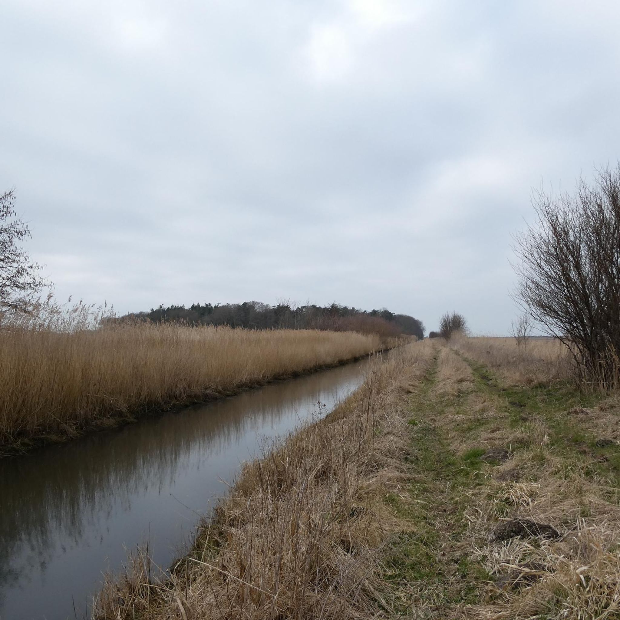
Quiet canal section south of Poyntzpass, where the towpath runs tightly along the narrow water. The bank is lightly overgrown with low trees and hedges, giving the stretch an intimate, green impression. The water is mostly still, forming a straight line through the open agricultural landscape. An even, traffic-free segment ideal for quiet miles on the towpath.
1
0
The Newry Canal Towpath is a 32-kilometer-long, almost entirely traffic-free green corridor connecting the towns of Portadown and Newry. It follows the towpath of the oldest canal in the British Isles, opened in 1742 to transport coal from County Tyrone to the sea. The Newry Canal Towpath offers an unparalleled cycling experience through the tranquil heart of County Armagh and County Down. This historic route, part of the National Cycle Network Route 9, takes you along a flat and largely asphalted path past fourteen monumental locks and characteristic lock-keeper's cottages. As you follow the waterway, you'll traverse a varied landscape of dense forests and open meadows, passing through welcoming villages like Scarva and Poyntzpass along the way. The path is a haven for wildlife; keep an eye out for kingfishers, swans, and otters that inhabit the reed beds. Whether you cycle the full 32 kilometers or explore just a section, the combination of industrial history and natural beauty makes this one of the absolute gems of Irish cycling routes.
1
0

Added to the collection: komoot.com/de-de/collection/3600632/-naturdenkmaeler-besondere-baeume-und-weitere-schaetze-der-natur
0
0

Silent Valley Reservoir, nestled in the Mourne Mountains, is a peaceful retreat surrounded by sweeping granite peaks and heathered slopes. Built in the early 20th century to supply water to Belfast and much of County Down, the reservoir combines striking engineering with natural beauty. Visitors can stroll along well-kept paths, admire the Victorian-style dam and impressive Mourne Wall, or simply enjoy the quiet atmosphere by the lakeshore.
4
1

Hollie Berrie is a good place for refreshments on the route at Scarva
0
1

The well-maintained trails take you through impressive scenery, surrounded by the striking peaks of the Mournes. The view of the Mourne Wall, which stretches for 35 kilometers and connects 15 peaks, is particularly impressive. However, some sections can become slippery in wet weather, so caution is advised. A highlight is a visit to Ben Crom Reservoir, which can be reached via an extension of the route. Note that there is a fee to enter the park.
1
1
The gently ascending road winds through a wide, open landscape, surrounded by grassy hills and breathtaking silence. Only the wind and the quiet hum of the tires accompany you here as your gaze wanders into the distance. The climb may be challenging, but the view that opens up with every meter of altitude is worth the effort. Once at the top, you feel free and rewarded, as if you have conquered a piece of nature and then the reward comes with the descent.
0
0
This impressive tree, which has stood here for centuries, is a testament to the region's rich natural history. The paths leading there lead through dense forest and offer a pleasant ride away from traffic. However, some sections are slippery in wet weather, so care should be taken. A particular highlight is the proximity to the Cloughmore Stone, a huge boulder that was transported here during the last Ice Age.
1
0
Frequently Asked Questions
How many touring cycling routes are available around Ballinliss?
There are over 50 touring cycling routes around Ballinliss, offering a diverse range of experiences. These include 6 easy routes, 25 moderate routes, and 27 difficult routes, catering to various skill levels.
What kind of terrain can I expect on touring cycling routes in Ballinliss?
The terrain around Ballinliss is quite varied, characterized by the unique volcanic landscape of the Ring of Gullion Area of Outstanding Natural Beauty. You'll find quiet country roads, well-surfaced tarmac, forest tracks, and moderately steep hills. Routes also feature tranquil lakes like Camlough Lake and the relatively flat paths along the Newry Canal.
Are there any easy touring cycling routes suitable for beginners or families?
Yes, Ballinliss offers several easy touring cycling routes. A great option for a relatively flat and scenic ride is the Newry Canal Way Loop, which follows the tranquil Newry Canal. Another moderate option that can be adapted for families is the Newry to Jerrettspass loop on the Newry Canal Path.
Can I find challenging routes for experienced touring cyclists?
Absolutely. For experienced touring cyclists seeking a challenge, the Ring of Gullion loop from Newry is a difficult 43.6-mile (70.2 km) trail that explores the distinctive volcanic landscape with significant elevation changes. Another demanding option is the Newry to Castlewellan loop, which covers over 66 miles (106 km) with substantial climbs.
Are there circular touring cycling routes in the Ballinliss area?
Yes, many touring cycling routes in the Ballinliss area are circular, allowing you to start and end at the same point. Examples include the Ring of Gullion loop from Newry, the Newry Canal Way Loop, and the Newry to 'The Old Oak' Kilbroney Park loop.
What natural attractions or landmarks can I see along the routes?
Touring cycling routes around Ballinliss offer access to stunning natural features. You can explore the unique volcanic landscape of the Ring of Gullion, including climbs up Fathom Mountain and Black Mountain for panoramic views. Tranquil spots like Camlough Lake and Calliagh Beara Lough provide peaceful cycling experiences. The area also features significant natural monuments such as Slieve Gullion Summit and North Cairn of Slieve Gullion.
Are there any historical or cultural points of interest to explore while cycling?
Yes, the region is rich in history and culture. You can discover ancient monuments like Neolithic burial chambers, including the large cairn on Slieve Gullion and Clontygora Court Grave. Routes may also pass by sites such as the Druids' Circle in Ravensdale Forest, Derrymore House (a National Trust property), and the Mullach Ban Folk Museum, offering insights into local heritage.
What do other cyclists say about touring cycling in Ballinliss?
The touring cycling routes in Ballinliss are highly rated by the komoot community, with an average score of 4.5 stars from over 40 reviews. Cyclists often praise the diverse landscape, the mix of quiet country roads and forest tracks, and the scenic beauty of the Ring of Gullion. Many appreciate the variety of routes available for different skill levels.
Is it possible to access touring cycling routes using public transport?
While specific public transport connections directly to all trailheads might vary, Newry, a major town near Ballinliss, serves as a hub with train and bus services. Many routes, such as those along the Newry Canal or starting from Newry, are accessible from the town, making it a convenient starting point if you're using public transport.
Where can I park my car when starting a touring cycling route in Ballinliss?
Parking options are generally available in and around the main towns and villages that serve as common starting points for routes, such as Newry. For routes venturing into the Ring of Gullion or forest areas, look for designated car parks near trailheads or visitor centers. Always check local signage for parking regulations and availability.
What is the best time of year to go touring cycling in Ballinliss?
The best time for touring cycling in Ballinliss is typically during the spring, summer, and early autumn months (April to October). During these periods, the weather is generally milder, and the days are longer, allowing for more comfortable and extended rides. The unique volcanic landscape and lush scenery are particularly vibrant during these seasons.
Are there places to stop for refreshments or food along the touring routes?
Yes, many touring routes around Ballinliss pass through or near charming villages and towns like Newry, Carlingford, and Rostrevor, where you can find cafes, pubs, and restaurants. It's advisable to plan your route and check for amenities in advance, especially on longer or more remote trails, to ensure you have refreshment stops available.
Most popular attractions around Ballinliss

Get inspired with the komoot mobile app


Explore more
Browse the best Cycling routes in other regions.
