The best road cycling routes around Pimperne
4.5
(71)
2,331
riders
14
rides
Road cycling routes around Pimperne traverse the scenic Cranborne Chase and West Wiltshire Downs Area of Outstanding Natural Beauty. The terrain features a mix of clear tracks along shallow valleys, undulating chalk hills, and wide-open fields, offering varied long-distance views. Cyclists can expect routes that range from relatively flat sections, such as parts of the North Dorset Trailway, to more challenging climbs like those leading to Win Green Summit. This diverse landscape provides a compelling backdrop for road cycling, catering…
Last updated: October 7, 2026
71
riders
88.2km
04:08
760m
760m
Moderate road ride. Good fitness required. Some segments of this route may be unpaved and difficult to ride.
5.0
(2)
61
riders
37.5km
01:41
290m
290m
Easy road ride. Great for any fitness level. Mostly well-paved surfaces and easy to ride.

5.0
(1)
18
riders
37.0km
01:36
290m
290m
Easy road ride. Great for any fitness level. Mostly well-paved surfaces and easy to ride.
17
riders
32.4km
01:34
390m
390m
Moderate road ride. Good fitness required. Mostly well-paved surfaces and easy to ride.
9
riders
52.6km
02:43
580m
580m
Moderate road ride. Good fitness required. Mostly well-paved surfaces and easy to ride.
Get access to more routes and recommendations from other explorers.
Already have an account?
Our route recommendations are based on thousands of hikes, rides, and runs completed by other people on komoot.
Start today with a free account
Your next adventure awaits.

Tips from the Community


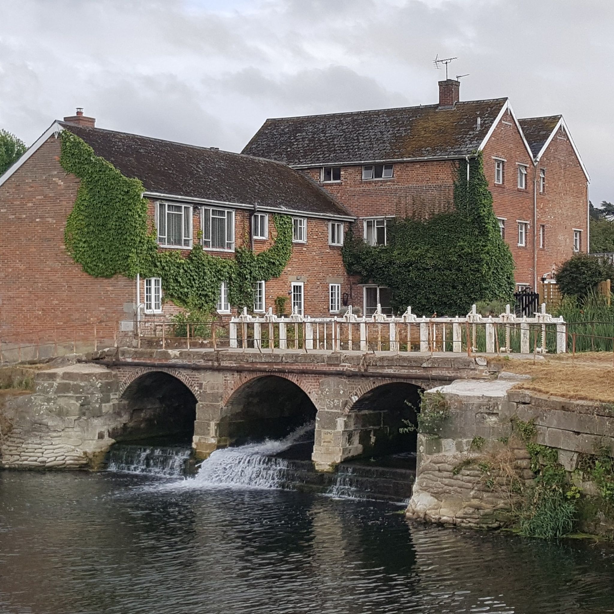
A beautiful ancient bridge lovely views in all seasons x
0
0


White Mill is an 18th-century water powered corn mill near Sturminster Marshall in Dorset on the River Stour which is in the care of the National Trust. The first record of a mill on the site is from Domesday Book; the current watermill was rebuilt in 1776 and extensively repaired in 1994. It still retains its original elm and applewood machinery though this can no longer be used. The mill and house are both built of brick with tiled roofs. The mill house has two stories whist the mill has three with an attic. The house has a single story lean-to extension and a timber porch. The machinery and mill stones remain but the two water wheels are no longer present. The present mill is thought to be on the site of an earlier one, probably one of those mentioned in Domesday Book. The current mill was rebuilt in 1776 on older foundations. The tenancy of the mill was the held by successive members of the Joyce family. The mill worked under water power until 1866 when a severe winter flood caused damage that was deemed beyond economic repair. The miller at the time was also a baker and he converted half of the mill to run from a portable steam engine to supply his bakery with flour. The last miller retired at the end of the 19th-century and the mill was not used again
1
0
There are documentary references to the building of "A Bridge on the River Stour adjacent to the White Mill" in the year 1175. Although the bridge you'll see today is probably a sixteenth century structure (somewhat hacked around by the Victorians). It is known, from an investigation of the foundations a few years ago, that the bridge stands on timber pilings which have themselves been carbon dated to the twelfth century. This is alleged to be the oldest bridge site in Dorset. Note the bridge warning plate "Any person wilfully damaging any part of this County Bridge will be guilty of Felony and upon conviction liable to be Transported For Life by the court"
1
0
Eye Bridge in Wimborne is on the River Stour. It has plenty of parking right next to the river, however, it can quickly fill up on a summers weekend. Eyebridge is a lovely spot to Paddleboard, you can head up stream for a good 5+ miles and there’s also a pub stop off at the end (Coventry Arms) if you fancy it.
0
0
Frequently Asked Questions
How many road cycling routes are available around Pimperne?
There are over 15 road cycling routes around Pimperne, offering a diverse range of options for cyclists. These routes traverse the scenic Cranborne Chase and West Wiltshire Downs Area of Outstanding Natural Beauty.
What kind of terrain and difficulty can I expect on road cycling routes in Pimperne?
Pimperne's road cycling routes feature a varied terrain, including clear tracks along shallow valleys, undulating chalk hills, and wide-open fields. You'll find a mix of easy, moderate, and difficult routes. For instance, the The Cliff Ascent – St Mary the Virgin Church loop from Pimperne is a moderate route with significant elevation gain, while the North Dorset Trailway – Blandford Forum Market Place loop from Blandford Forum offers a smoother, easier ride with flatter sections.
Are there any easy or family-friendly road cycling routes in the Pimperne area?
Yes, Pimperne offers several easy road cycling options. The North Dorset Trailway – Blandford Forum Market Place loop from Blandford Forum is an easy 23.3-mile path that includes sections of the relatively flat North Dorset Trailway, making it suitable for a more relaxed ride. Another easy option is the Blandford Forum Market Place – White Mill Bridge loop from Pimperne, which is 22.9 miles long and leads through the scenic Stour Valley.
Where can I find challenging road cycling routes with significant climbs around Pimperne?
For those seeking a challenge, routes like The Cliff Ascent – St Mary the Virgin Church loop from Pimperne offer significant elevation gain over its 55 miles. The region's chalk hills provide opportunities for climbs, with notable features like the Zig Zag Hill Climb offering impressive vistas from the top of Wingreen Hill.
What are some scenic viewpoints or landmarks I can see while road cycling near Pimperne?
The Pimperne area is rich in scenic viewpoints and historical landmarks. You can cycle towards destinations like Win Green Summit, the highest point in Cranborne Chase, which offers panoramic views over Blackmore Vale and Salisbury Plain. Hambledon Hill Iron Age hill fort also provides stunning views into Wiltshire and Somerset. The Zig Zag Hill Climb is another scenic spot with impressive vistas.
Are there any circular road cycling routes around Pimperne?
Yes, many of the road cycling routes around Pimperne are designed as loops. Examples include The Cliff Ascent – St Mary the Virgin Church loop from Pimperne, the North Dorset Trailway – Blandford Forum Market Place loop from Blandford Forum, and the Blandford Forum Market Place – White Mill Bridge loop from Pimperne. These circular routes allow you to start and end in the same location, making planning easier.
What natural features define the road cycling experience in Pimperne?
The road cycling experience in Pimperne is largely defined by its location within the Cranborne Chase and West Wiltshire Downs AONB. Cyclists will encounter chalk hills, shallow valleys, and wide-open fields. The landscape also features woodlands with coppiced hazel and ancient oaks, and the River Stour forms part of the scenic Stour Valley Way south of Blandford Forum.
What do other road cyclists say about the routes in Pimperne?
The road cycling routes in Pimperne are highly rated by the komoot community, with an average score of 4.7 stars from over 4 reviews. Cyclists often praise the varied terrain, the scenic beauty of the Cranborne Chase AONB, and the mix of challenging climbs and smoother, flatter sections like those found on the North Dorset Trailway.
Is there public transport access to the road cycling routes in Pimperne?
While Pimperne is a rural village, Blandford Forum, a nearby town, serves as a hub for some routes, such as the North Dorset Trailway – Blandford Forum Market Place loop from Blandford Forum. Public transport options to Blandford Forum may be available, but it's advisable to check local bus schedules for connections to Pimperne or starting points for specific routes.
Are there any specific long-distance road cycling trails available from Pimperne?
While not a single named long-distance trail, the extensive network of rural roads and connections to paths like the North Dorset Trailway allow for extended rides. Routes such as The Cliff Ascent – St Mary the Virgin Church loop from Pimperne, at 55 miles (88.5 km), offer a substantial distance for a day's cycling, and can be combined with other routes for even longer excursions.
What is the best time of year for road cycling in Pimperne?
The Pimperne area, like much of Dorset, is generally pleasant for road cycling during spring, summer, and early autumn. These seasons typically offer milder weather and longer daylight hours, making for more enjoyable rides through the open fields and along the chalk hills. Always check local weather conditions before heading out.
Most popular routes around Pimperne
Most popular attractions around Pimperne

Get inspired with the komoot mobile app


Explore more
Browse the best Road cycling routes in other regions.
