The best walks and hikes around Kinghill
4.6
(662)
5,366
hikers
90
hikes
Hiking around Kinghill provides access to the granite peaks and rolling hills of the Mourne Mountains. The region is characterized by a network of trails that navigate past high country loughs, along historic stone walls, and up to summits with expansive views. These routes offer a mix of moderate ascents and more challenging mountain hikes. The landscape features granite mountain formations and high loughs.
Best hiking trails around Kinghill
- The most popular hiking route is Slieve Loughshannagh, Meelbeg and Meelmore…
Last updated: November 11, 2026
4.7
(50)
448
hikers
6.85km
02:04
230m
230m
Moderate hike. Good fitness required. Easily walkable paths.
4.8
(32)
131
hikers
9.39km
03:10
490m
490m
Moderate hike. Good fitness required. Easily walkable paths.

4.9
(8)
59
hikers
8.00km
02:46
410m
410m
Moderate hike. Good fitness required. Easily walkable paths.
4.3
(7)
44
hikers
5.64km
01:48
240m
240m
Easy hike. Easily walkable paths.
4.7
(3)
24
hikers
15.4km
05:28
870m
870m
Hard hike. Very good fitness required. Easily walkable paths.
Get access to more routes and recommendations from other explorers.
Already have an account?
Our route recommendations are based on thousands of hikes, rides, and runs completed by other people on komoot.
Start today with a free account
Your next adventure awaits.

Tips from the Community


Hare's Gap is a dramatic mountain pass nestled in the heart of the Mourne Mountains. This striking pass, situated between Slieve Bearnagh and Slievenaglogh, offers hikers a blend of natural beauty and historical intrigue. From this vantage point, hikers are treated to panoramic views of the surrounding peaks and valleys. The pass itself is historically significant, having once served as a route for smuggling goods across the mountains, adding a layer of intrigue to the hike. Hare's Gap is a popular starting point for various hikes, including ascents of Slieve Bearnagh and Slieve Meelmore.
2
0
Reaching the summit of Slieve Meelbeg (716 m) feels like discovering a quiet treasure in the Mourne Mountains. From the top, you’re greeted by sweeping views of Slieve Bearnagh and Slieve Donard, their rugged forms unfolding across the horizon. The climb isn’t overly technical, making it accessible to many hikers.
1
0
That moment where the mountain trail opens up to sea view bliss. Standing at this lookout in the Mourne Mountains, you’re treated to a wide, sweeping scene. A simple, beautiful reward for your walk, one of those views you’ll want to revisit in your memory long after the hike.
1
0
This spot isn't just a geographic point, it's where paths converge and views open to both the remote moorland above and the familiar valleys behind. Shared by more than 90% of visitors, its quiet drama and sweeping outlooks make it a memorable pause on any Mourne hike.
1
0
Hare’s Gap is one of the most iconic passes in the Mourne Mountains, marked by its rugged stile and dramatic views that open up across the range. Once a historic smuggling route, it remains a natural gateway into the high Mournes, with steep paths and striking rock formations framing the way. From here, the landscape unfolds in every direction, making it a perfect spot to pause, take in the scenery, and appreciate the wild beauty of these mountains.
4
0
On the summit of Slieve Meelmore stands a small stone shelter, a welcome spot to rest after the steady climb up. From here, the views stretch across the Mournes, with Slieve Bearnagh’s rocky tors dominating the skyline. The shelter gives hikers a place to pause, shielded from the wind, and enjoy the sweeping mountain scenery before continuing along the Mourne Wall.
3
0
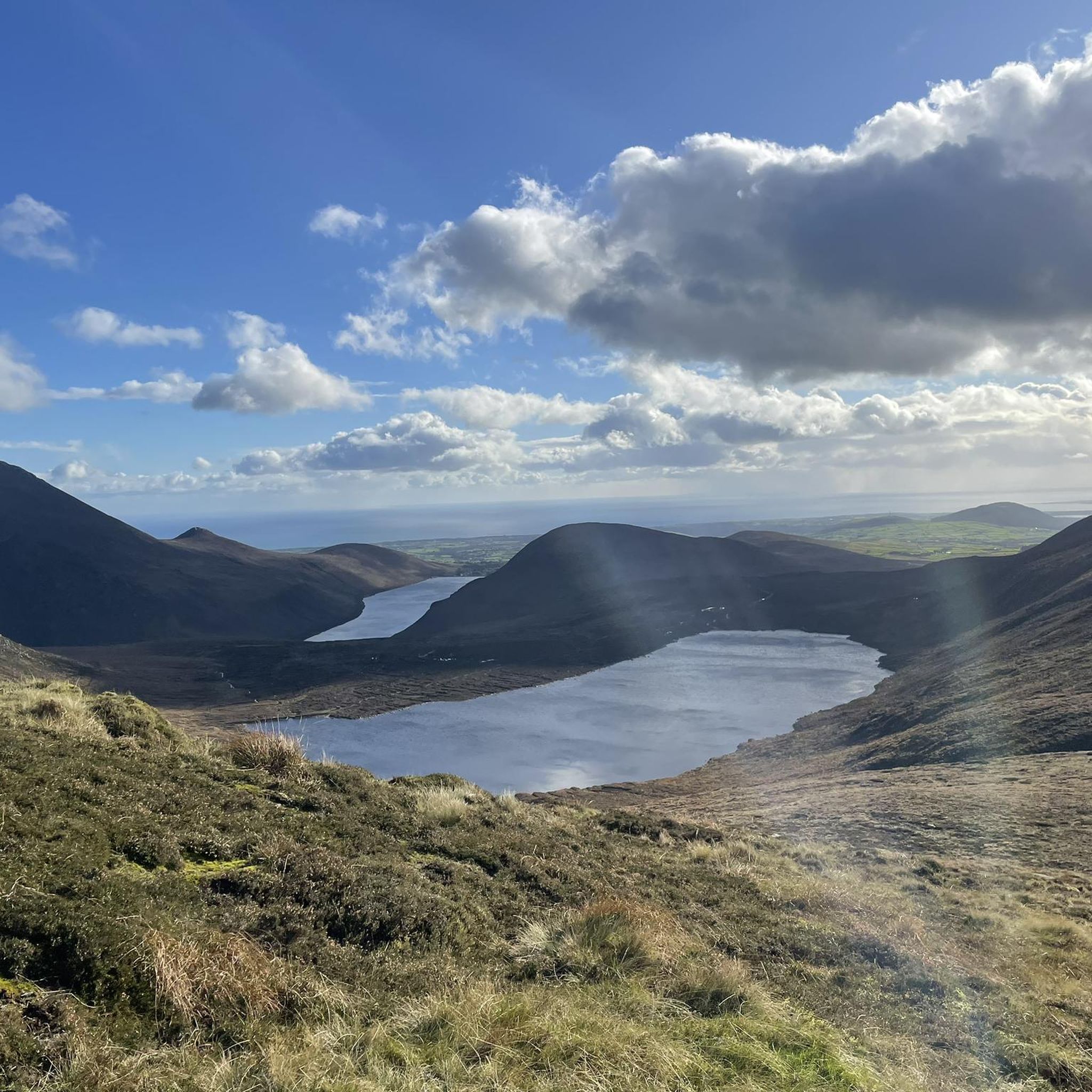
Slieve Loughshannagh is one of the quieter summits in the Mourne Mountains, but it rewards hikers with wide, open views over Silent Valley, Slieve Binnian, and the western Mournes. The climb isn’t too demanding, and the summit has a peaceful, windswept feel, making it a lovely spot to pause and take in the rugged beauty of the landscape.
4
0
Frequently Asked Questions
Are there any easy, family-friendly hikes in the Kinghill area?
Yes, there are several options suitable for families. While many trails involve mountain ascents, you can find easier paths. For a shorter walk with rewarding views that isn't too strenuous, consider the Slieve Loughshannagh summit – Mourne Wall loop from Kilcoo. It's a manageable distance and follows part of the historic Mourne Wall.
Can I bring my dog on the hiking trails around Kinghill?
Dogs are often welcome on the trails in the Mourne Mountains, but it's essential to keep them under control, especially near livestock which graze freely in the hills. Always check local signage at trailheads for specific rules. Trails are often open and exposed, so ensure you bring enough water for your dog as well.
What are the parking options for hiking in Kinghill?
Most popular trailheads have designated car parks, such as those near Kilcoo or the Upper Bann area. These can fill up quickly, particularly on weekends and during good weather. It's always a good idea to arrive early to secure a spot. Some less common routes may rely on limited roadside parking, so please park considerately and do not block access.
Are there any circular or loop hikes available?
The region is excellent for loop hikes, allowing you to experience a variety of scenery without backtracking. Many popular routes are circular, combining ascents, ridge walks, and descents. A great example of a moderate loop is the Ben Crom – Mourne Wall loop from Kilcoo, which takes you around the Ben Crom Reservoir.
I'm looking for a challenging day hike. What do you recommend?
For experienced hikers seeking a challenge, the Mourne Mountains offer strenuous routes with significant elevation gain. The Slieve Doan – Hare's Gap loop from Upper Bann is a difficult and long trail that rewards with fantastic views from the high mountain pass known as Hare's Gap.
What kind of gear should I pack for a hike in Kinghill?
The weather in the Mourne Mountains can change rapidly. Sturdy, waterproof hiking boots are essential due to the rocky and often boggy terrain. Always carry waterproof outerwear, even on a clear day. Layering is key, so pack a fleece or warm mid-layer. A map, compass, and a fully charged phone are critical for navigation, along with plenty of water and snacks.
How many hiking trails are there around Kinghill?
There are nearly 100 curated hiking routes to explore around Kinghill on komoot. These range from easy walks to challenging multi-peak mountain traverses, offering options for all fitness and experience levels.
What do other hikers say about the trails in Kinghill?
The trails are highly regarded by the komoot community, with an average rating of 4.6 out of 5 stars. Hikers frequently praise the stunning panoramic views from the summits, the unique landscape of granite peaks, and the sense of history felt when walking alongside the Mourne Wall.
Are there any trails with good scenic viewpoints?
Virtually all the mountain trails offer spectacular scenic viewpoints. For a route that provides a fantastic perspective without being overly difficult, the Blue Quarry to Slieve Doan — Mourne trail is an excellent choice. The summit of Slieve Doan is known for its 360-degree views of the surrounding high Mournes.
Is it possible to get to the trails using public transport?
Accessing the Mourne Mountains via public transport can be challenging as many trailheads are in remote locations. Bus services run to nearby towns like Newcastle or Kilkeel, but you will likely need a taxi for the final leg to the main car parks. It's best to check local bus timetables in advance and plan for additional travel time.
What is the terrain like on the hiking trails?
The terrain is varied but typically involves rocky paths, open moorland, and steep ascents. You'll be walking on granite, and some sections of trail can be boggy and wet, especially after rain. Good footing and appropriate footwear are crucial for navigating the landscape safely.
Most popular routes around Kinghill
Most popular attractions around Kinghill

Get inspired with the komoot mobile app


Explore more
Browse the best Hikes in other regions.
