The best walks and hikes around Tejeda Y Segoyuela
4.8
(14)
131
hikers
11
hikes
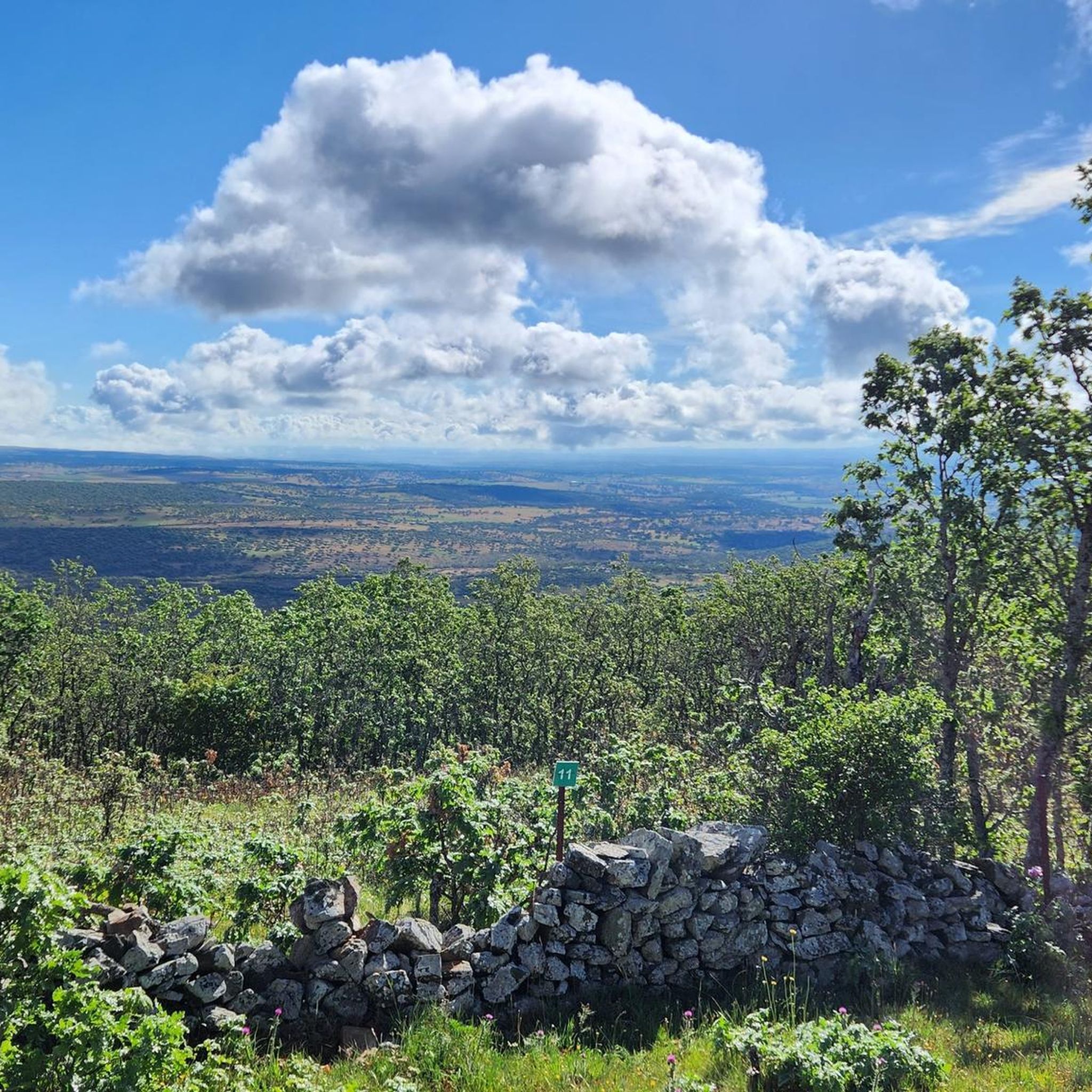
Hiking around Tejeda Y Segoyuela offers access to the scenic Sierra de Francia, a region known for its natural beauty and diverse ecosystems. The area features oak and chestnut forests, with the village itself hinting at ancient yew woodlands. Situated within a Natura 2000 protected area, the terrain includes parts of the Sierra Mayor mountain range, providing varied landscapes for outdoor activities.
Best hiking trails around Tejeda Y Segoyuela
- The most popular hiking route is Sendero de las Honfrías -…
Last updated: June 28, 2026
25
hikers
Moderate hike. Good fitness required. Easily-accessible paths. Suitable for all skill levels.
4.6
(5)
9
hikers
Moderate hike. Good fitness required. Easily-accessible paths. Suitable for all skill levels.

Sign up for free
25
hikers
7.59km
02:11
190m
190m
Moderate hike. Good fitness required. Easily-accessible paths. Suitable for all skill levels.
4.5
(6)
30
hikers
18.9km
05:28
500m
500m
Hard hike. Very good fitness required. Easily-accessible paths. Suitable for all skill levels.
5.0
(1)
8
hikers
4.51km
01:21
150m
150m
Easy hike. Great for any fitness level. Easily-accessible paths. Suitable for all skill levels.
Get access to more routes and recommendations from other explorers.
Sign up for free
Already have an account?
Our route recommendations are based on thousands of hikes, rides, and runs completed by other people on komoot.
Start today with a free account
Your next adventure awaits.
Login or Signup
Popular around Tejeda Y Segoyuela

Tips from the Community

Located between the municipalities of Navarredonda de la Rinconada and Escurial de la Sierra, in the Sierra de Francia-Quilamas region. A protected natural area within the Natura 2000 network, with oak and chestnut forests and wildlife such as the golden eagle and griffon vulture.
5
0

The top of Pico Cervero is located at 1,522 meters above sea level within the wonderful Natural Space of Las Quilamas. The ascent is demanding and depending on where you climb it from, it may have some technical sectors. From Linares de Riofrío you can follow the path through the Honfrías forest, a wonderful and picturesque place.
1
1

La Morana or Quintos fountain, belonging to the La Honfría forest. According to posters in the area up to this source "the Fifth of the town went up to wash at the beginning of December".
1
0
The most recommended times for this route are May, well into spring and autumn. The landscapes of the area with the trees covered with leaves are highly recommended, especially the forest of La Honfría.
1
0

Magical place, excellent 360º views (if it is not cloudy). It is worth the ascent both by mountain bike, gravel or walking.
1
0

El Cervero is the highest peak in the Sierra de las Quilamas, with an altitude of 1465 meters
1
0
Pico Cervero. Spectacular views of the entire Sierra de Francia
1
0
Frequently Asked Questions
What types of hiking trails can I find around Tejeda y Segoyuela?
The area around Tejeda y Segoyuela offers a variety of hiking trails, catering to different skill levels. You'll find 9 routes in total, including 1 easy, 7 moderate, and 1 difficult option. These trails often traverse the scenic oak and chestnut forests characteristic of the Sierra de Francia region.
What is the best time of year to go hiking in Tejeda y Segoyuela?
Tejeda y Segoyuela experiences a continental climate. While winters are cold and dry, and summers are warm and brief, the shoulder seasons (spring and autumn) are generally ideal for hiking. During these times, you can enjoy the region's natural beauty, including its diverse forests and wildlife, in comfortable temperatures.
Are there any family-friendly hiking options in Tejeda y Segoyuela?
Yes, there is at least one easy route suitable for families. The area's natural beauty, with its oak and chestnut forests, provides a pleasant environment for walks with children. Consider the Pico Cervero (1,482 m) – Cervero Peak loop from Refugio Campo Escurial, which is an easy 4.5 km loop.
Can I bring my dog on the hiking trails in Tejeda y Segoyuela?
Most hiking trails in natural areas like Tejeda y Segoyuela are dog-friendly, provided your dog is kept under control, especially due to the presence of local wildlife such as golden eagles and griffon vultures. Always ensure to follow local regulations and clean up after your pet.
Are there any circular hiking routes available?
Yes, many routes in the area are circular, allowing you to start and end at the same point. For example, you can explore the Sendero de las Honfrías - circular from Linares de Riofrío - Espacio Natural de las Quilamas, a moderate 7.2 km loop, or the Pico Cervero – circular from Navarredonda de la Rinconada - Espacio Natural de las Quilamas, a longer 14.7 km moderate path.
What interesting landmarks or natural features can I see while hiking?
The region is rich in natural and historical attractions. You can encounter prominent natural features like Cervero Peak and the Ascent to Puerto de Valero. The village itself features traditional architecture and the remains of the 15th-century Casa-fuerte del Señor de Tejeda. You might also spot a small lagoon in Navarredonda de la Rinconada.
What do other hikers enjoy most about the trails in Tejeda y Segoyuela?
The trails in Tejeda y Segoyuela are highly regarded by the komoot community, with an average rating of 4.8 stars from over 10 reviews. Hikers often praise the diverse terrain, the beauty of the oak and chestnut forests, and the opportunity to explore a protected natural area within the Sierra de Francia.
Are there options for longer, more challenging hikes?
Yes, for those seeking a greater challenge, there is one difficult route available. The Cervero Peak – Pico Cervero (1465 m) loop from Linares de Riofrío is a demanding 18.9 km trail with significant elevation gain, offering expansive views of the Sierra de Francia.
What are the typical trail lengths for hikes in this area?
Trail lengths vary significantly, from shorter, easy walks to longer, more challenging excursions. You can find routes like the 4.5 km Pico Cervero (1,482 m) – Cervero Peak loop from Refugio Campo Escurial, up to the 18.9 km Cervero Peak – Pico Cervero (1465 m) loop from Linares de Riofrío, with many moderate options in between.
Is public transport or parking available for accessing the trailheads?
While specific public transport details for individual trailheads are not always available, Tejeda y Segoyuela is a village, and access is typically by car. Parking is generally available in or near the villages that serve as starting points for these trails, such as Linares de Riofrío or Navarredonda de la Rinconada.
What kind of terrain can I expect on the hikes around Tejeda y Segoyuela?
The terrain around Tejeda y Segoyuela is characterized by its location within the Sierra de Francia and Sierra Mayor. You can expect varied landscapes, including paths through oak and chestnut forests, and ascents that offer views of the surrounding mountains. The trails range from relatively flat sections to more challenging inclines, especially on routes leading to peaks like Cervero.
Most popular routes around Tejeda Y Segoyuela
Most popular attractions around Tejeda Y Segoyuela

Get inspired with the komoot mobile app


Explore more
Browse the best Hikes in other regions.
