The best road cycling routes around Champ-Du-Boult
4.4
(33)
1,121
riders
264
rides
Road cycling routes around Champ-Du-Boult traverse the varied landscapes of the Bocage Normand, characterized by rolling hills, green valleys, and dense hedgerows. The region offers a mix of forested areas and open pastures, providing diverse terrain for cyclists. Routes often feature moderate ascents and descents, reflecting the undulating nature of the Norman countryside. This geographical composition creates an engaging environment for road cyclists seeking both scenic beauty and varied gradients.
Best road cycling routes around Champ-Du-Boult
- The most popular road…
Last updated: July 7, 2026
8
riders
25.6km
01:15
380m
380m
Moderate road ride. Good fitness required. Mostly well-paved surfaces and easy to ride.
6
riders
30.1km
01:21
330m
330m
Moderate road ride. Good fitness required. Mostly well-paved surfaces and easy to ride.

Sign up for free
5
riders
22.8km
01:09
300m
300m
Easy road ride. Great for any fitness level. Mostly well-paved surfaces and easy to ride.
5
riders
10.8km
00:33
140m
140m
Easy road ride. Great for any fitness level. Mostly well-paved surfaces and easy to ride.
5.0
(1)
3
riders
59.3km
02:53
770m
770m
Moderate road ride. Good fitness required. Some segments of this route may be unpaved and difficult to ride.
Get access to more routes and recommendations from other explorers.
Sign up for free
Already have an account?
Our route recommendations are based on thousands of hikes, rides, and runs completed by other people on komoot.
Start today with a free account
Your next adventure awaits.
Login or Signup

Tips from the Community

The abbey church is Gothic in style and was built in the 13th century. It has been classified as a historic monument since 1881, and is considered to be one of the most beautiful works of religious architecture in the Bocage Normand.
0
0

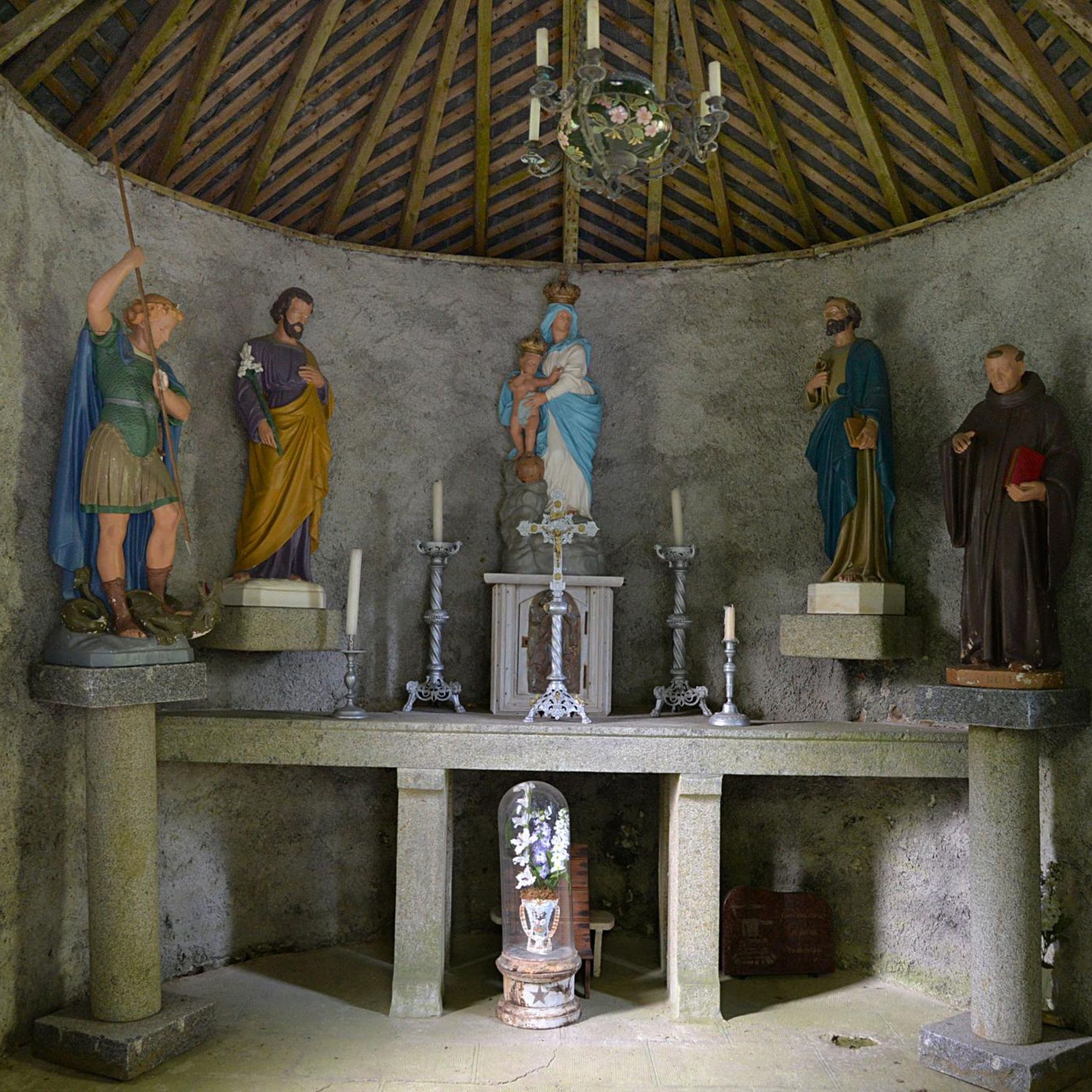
he cave of Bion is a place of pilgrimage located in the commune of Sainte-Marie-Outre-L’eau. Around 1830, two workers from Pont-Farcy, whose initials are only known (M.L and M.B), placed a statuette of the Virgin in the hollow of an old oak tree at a place called Bion. Unfortunately the oak fell in 1917. The statue was restored in 1925. In 1932, a grotto intended to house the statue of the Virgin was built on the model of Lourdes. The first cave is destroyed and rebuilt, the consecration takes place on May 2, 1937, in front of 3000 faithful. In 1946, a chapel was erected above the cave. For a long time two pilgrimages took place each year, on May 2 and September 8. Today, the pilgrimage takes place at the Assumption on August 15.
0
1
The cave of Bion is a place of pilgrimage located in the commune of Sainte-Marie-Outre-L'eau. Around 1830, two workers from Pont-Farcy, whose initials are only known (M.L and M.B), placed a statuette of the Virgin in the hollow of an old oak tree at a place called Bion. Unfortunately the oak fell in 1917. The statue was restored in 1925. In 1932, a grotto intended to house the statue of the Virgin was built on the model of Lourdes. The first cave is destroyed and rebuilt, the consecration takes place on May 2, 1937, in front of 3000 faithful. In 1946, a chapel was erected above the cave. For a long time two pilgrimages took place each year, on May 2 and September 8. Today, the pilgrimage takes place at the Assumption on August 15.
1
0

In neo-Gothic style, it was consecrated in 1888. It houses, among other things, a very ornate granite stoup and a 15th century pieta.
0
0
In neo-Gothic style, it was consecrated in 1888. It houses, among other things, a very ornate granite stoup and a 15th century pieta.
2
0
(Open on request at the town hall) Classified as a historical monument in 1881, the abbey church of Saint-Sever is one of the most beautiful jewels of religious architecture in the Bocage Normand. The isolation of the bell tower astonishes the visitor. The Gothic-style abbey church was built in the 13th century. On the route do not miss the gardens of the abbey.
1
0
Frequently Asked Questions
How many road cycling routes are available around Champ-Du-Boult?
There are over 260 road cycling routes around Champ-Du-Boult, offering a wide range of options for different skill levels. You'll find everything from easy loops to more challenging rides with significant elevation gain.
What kind of terrain can I expect on road cycling routes in Champ-Du-Boult?
The terrain around Champ-Du-Boult is characterized by the Bocage Normand, featuring rolling hills, green valleys, and dense hedgerows. You can expect a mix of forested areas and open pastures, with moderate ascents and descents that reflect the undulating nature of the Norman countryside. This creates an engaging environment for road cyclists seeking both scenic beauty and varied gradients.
Are there easy or beginner-friendly road cycling routes in the area?
Yes, Champ-Du-Boult offers several easy road cycling routes. For instance, the Abbey Church of Saint-Sever loop from Le Gast is an easy 14.2-mile (22.8 km) trail that provides a gentler introduction to the region's landscapes.
What are some challenging road cycling routes around Champ-Du-Boult?
While many routes are moderate, the region's rolling hills mean you can find challenging sections. For a longer, more demanding ride, consider the Lake Dathée – Vire Municipal Museum loop from Saint-Manvieu-Bocage, which covers 27.0 miles (43.5 km) with over 600 meters of elevation gain, offering a good workout for experienced cyclists.
Can I find routes that pass by interesting landmarks or viewpoints?
Absolutely. Many routes incorporate local points of interest. For example, the Lake Dathée – Vire Municipal Museum loop from Saint-Manvieu-Bocage passes by the scenic Lac de la Dathée. You might also encounter historical markers like The roadside cross in the Forest of Saint-Sever, or the Motte Castrale and Étang du Vieux Château, offering scenic and historical diversions.
Are there any family-friendly road cycling options near Champ-Du-Boult?
Yes, the region offers family-friendly options, especially around natural features. The path around Lac de la Dathée is generally flat and picturesque, making it suitable for families. Additionally, Normandy features routes along old railway tracks, which provide smooth and gentle cycling paths amidst lush greenery, ideal for all ages.
What are the best times of year for road cycling in Champ-Du-Boult?
The best times for road cycling in Champ-Du-Boult are typically spring, summer, and early autumn. During these seasons, the weather is generally mild and pleasant, and the landscapes are at their most vibrant. The region's forests also provide welcome shade during warmer months.
Are there circular road cycling routes available?
Yes, many of the road cycling routes around Champ-Du-Boult are designed as loops, allowing you to start and finish at the same point. Examples include the Roadbike loop from Champ-du-Boult and the Saint-Louis Church loop from Lingeard, which are popular choices for exploring the local terrain.
Where can I find places to eat or stay along the routes?
Champ-Du-Boult and nearby towns like Saint-Michel-de-Montjoie offer various amenities. While specific cafes or accommodations aren't listed for each route, the region is dotted with charming villages where you can find local eateries and guesthouses. It's advisable to check local listings for cafes, pubs, and accommodation in towns along your chosen route.
How do other cyclists rate the routes in Champ-Du-Boult?
The road cycling routes in Champ-Du-Boult are highly rated by the komoot community, with an average score of 4.4 stars from over 20 reviews. Cyclists often praise the varied terrain, scenic beauty of the Bocage Normand, and the engaging mix of forested sections and open pastures.
Is it possible to access road cycling routes using public transport, or is parking available?
While specific public transport links directly to trailheads might be limited in rural areas like Champ-Du-Boult, many routes are accessible by car, and parking is generally available in the villages and towns where routes begin. For broader cycling networks in Normandy, you can find information on public transport options that accommodate bikes on the France Vélo Tourisme website.
What makes Champ-Du-Boult a good destination for road cycling?
Champ-Du-Boult is an excellent road cycling destination due to its diverse landscapes, including the rolling hills of the Bocage Normand, tranquil lakeside paths around Lac de la Dathée, and shaded routes through the Forest of Saint-Sever. This variety provides engaging rides for all levels, combined with charming villages and historical sites like Saint-Michel-de-Montjoie, making for a rich cycling experience.
Are there longer distance road cycling routes for more experienced riders?
Yes, for those seeking longer distances, you can combine local loops or explore connections to broader Norman cycling networks. The Lake Dathée – Vire Castle loop from Beauficel, at 25.5 miles (41.0 km), offers a substantial ride. The region's location within Normandy also provides access to major itineraries like La Vélo Francette for extended tours.
Most popular routes around Champ-Du-Boult
Most popular attractions around Champ-Du-Boult

Get inspired with the komoot mobile app


Explore more
Browse the best Road cycling routes in other regions.
