The best walks and hikes around Sorans-Lès-Breurey
4.3
(201)
1,020
hikers
90
hikes
Hiking around Sorans-Lès-Breurey offers diverse landscapes within the Haute-Saône department of France. The region is characterized by the Ognon River valley, extensive woodlands, and rolling hills with elevations ranging from approximately 221m to 363m. Trails often traverse prairies and provide views from belvédères over the valley. This area provides varied terrain for outdoor exploration.
Best hiking trails around Sorans-Lès-Breurey
- The most popular hiking route is View of the Ognon – Lavoir de Palise loop from Cromary, an easy 4.5…
Last updated: July 6, 2026
4.0
(25)
70
hikers
7.24km
01:53
50m
50m
Easy hike. Great for any fitness level. Easily-accessible paths. Suitable for all skill levels.
4.6
(5)
29
hikers
6.52km
01:44
70m
60m
Easy hike. Great for any fitness level. Easily-accessible paths. Suitable for all skill levels.

Sign up for free
4.4
(5)
27
hikers
5.38km
01:24
30m
30m
Easy hike. Great for any fitness level. Easily-accessible paths. Suitable for all skill levels.
3.6
(11)
22
hikers
10.5km
02:44
80m
80m
Moderate hike. Good fitness required. Easily-accessible paths. Suitable for all skill levels.
4.7
(3)
7
hikers
9.38km
02:31
110m
110m
Moderate hike. Good fitness required. Easily-accessible paths. Suitable for all skill levels.
Get access to more routes and recommendations from other explorers.
Sign up for free
Already have an account?
Our route recommendations are based on thousands of hikes, rides, and runs completed by other people on komoot.
Start today with a free account
Your next adventure awaits.
Login or Signup


Tips from the Community


bring your own provisions because you won't be able to sit on a terrace anywhere.
0
0

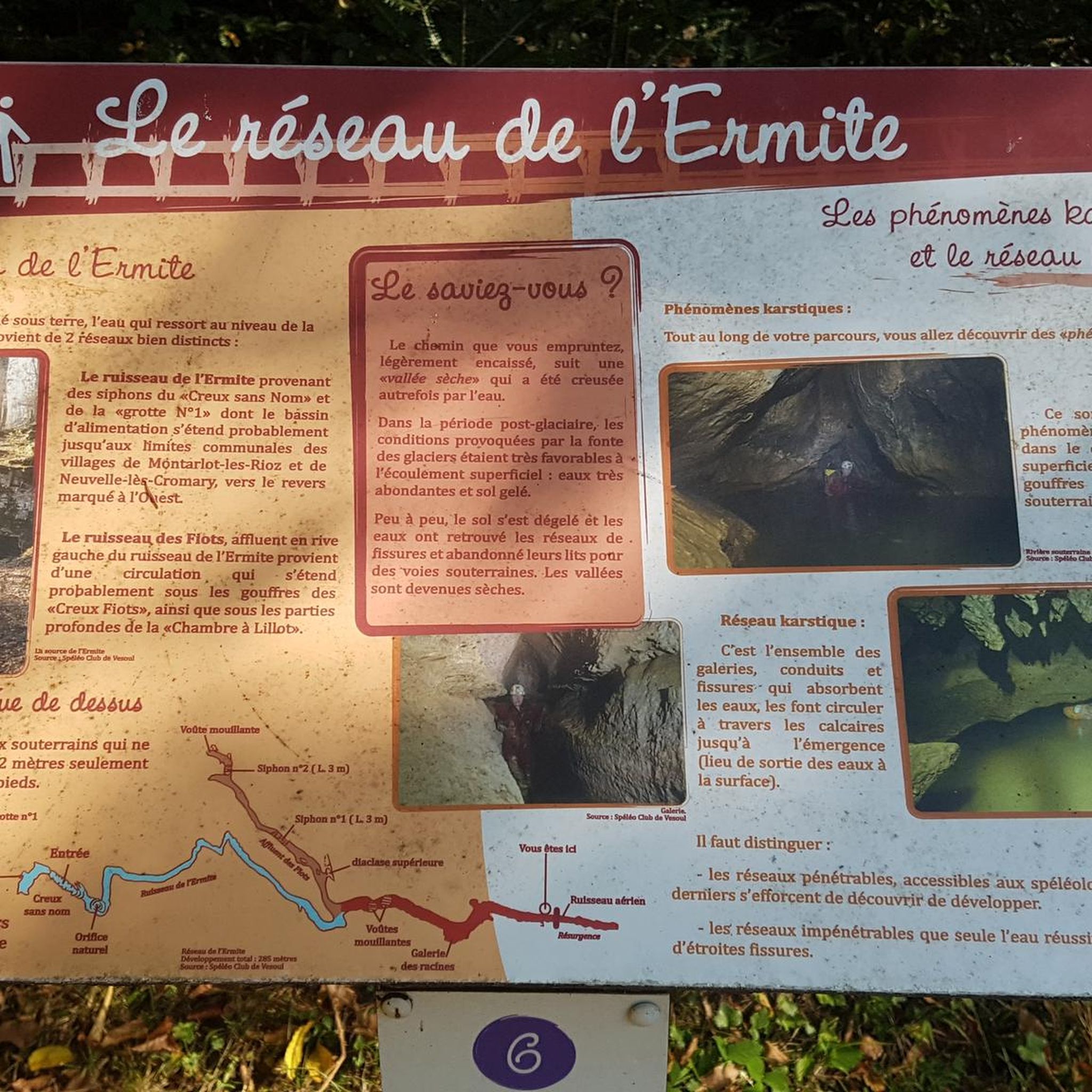
The Hermite is a small stream that, after its resurgence, runs for about two kilometers in wide meanders before flowing into the Buthiers, a tributary of the Ognon. The Buthiers is a river that comes from the Noirefond funnel north of Rioz. Before its resurgence, the Hermite runs through a recognized underground network for about 1049 m, of which 285 m can be traveled by man... I advise you to take a look at the site: https://www.lieux-insolites.fr/hsaone/ermite/ermite.htm
1
0
Hike along the Ognon and in pleasant forest and offering charming views of the river.
2
0
Fontaine-lavoir from 1822.
1
0
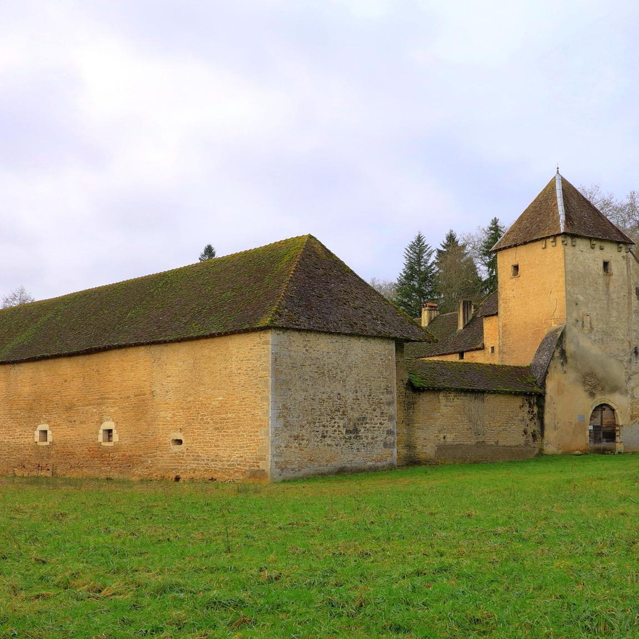
Built in the 18th century, it belonged to Marshal of the Empire Bon-Adrien Jeannot de Moncey.
0
0
Frequently Asked Questions
How many hiking trails are available around Sorans-Lès-Breurey?
There are over 80 hiking trails in the area around Sorans-Lès-Breurey, offering a diverse range of experiences. These routes are highly rated by the komoot community, with an average score of 4.4 stars from more than 170 reviews.
Are there easy hiking trails suitable for beginners or families in Sorans-Lès-Breurey?
Yes, Sorans-Lès-Breurey offers a good selection of easy trails. Approximately 33 routes are classified as easy, perfect for a relaxed stroll or a family outing. An example is the View of the Ognon – Lavoir de Palise loop from Cromary, which is 4.5 miles (7.2 km) long and takes about 1 hour 53 minutes.
What kind of landscapes can I expect to see while hiking in this region?
The region around Sorans-Lès-Breurey is characterized by diverse landscapes, including the picturesque Ognon River valley, extensive woodlands (known as 'sous-bois'), and rolling hills. You'll also find open prairies and stunning panoramic views from belvédères like the Chanois and Dame Blanche viewpoints, which offer vistas over the Ognon valley and even glimpses of the Vosges mountains.
Are there any circular walks available in Sorans-Lès-Breurey?
Many of the trails in Sorans-Lès-Breurey are designed as loops, providing convenient circular walks. For instance, the Lavoir de Palise loop from Palise is an easy 4.0 miles (6.5 km) path that explores the local scenery and a historic lavoir.
What historical or cultural attractions can I discover along the hiking routes?
Hiking in Sorans-Lès-Breurey allows you to combine natural exploration with historical discovery. Many routes pass by charming local villages, traditional lavoirs (washhouses), and even châteaux. The Château de Buthiers loop from Perrouse, for example, takes you past the Château de Buthiers. You can also explore highlights like the large washhouse-trough or the Fortified manor of Sorans-lès-Breurey.
Are there any challenging hiking trails for experienced hikers?
While there are no trails classified as 'difficult' in our current selection, there are 49 moderate routes that offer a more challenging experience than the easy paths. These routes often feature more elevation gain and longer distances, such as The Hermit network loop from Rioz, which is 9.3 km long.
What are some notable viewpoints or scenic spots in the area?
The region is known for its stunning belvédères. The Chanois and Dame Blanche viewpoints offer extensive panoramic views over the Ognon valley. The 'roches de la Dame Blanche' (rocks of the White Lady) are particularly noted for their wild beauty and local legends. You can also visit the Fort de la Dame Blanche for impressive vistas.
Can I find trails that follow the Ognon River?
Yes, the Ognon River valley is a significant natural feature of the area, and many trails offer picturesque views and opportunities for riverside walks. The View of the Ognon – Lavoir de Palise loop from Cromary provides excellent views of the Ognon River.
What do other hikers say about the trails in Sorans-Lès-Breurey?
The trails in Sorans-Lès-Breurey are highly regarded by the komoot community, with an average rating of 4.4 out of 5 stars from over 170 reviews. Hikers often praise the varied terrain, the peaceful woodlands, and the charming historical elements found along the routes.
Are there any forests or natural reserves to explore?
The area boasts extensive forests and woodlands, providing shaded and natural environments for hikers. You can immerse yourself in nature by exploring highlights like the majestic Chailluz Forest or the tranquil Grandes Baraques forest hamlet.
Are there any routes that connect multiple villages?
Many hiking routes in the region are designed to connect charming local villages, allowing you to experience the cultural fabric of the Haute-Saône. For example, the 'Le papillon à Voray-sur L'ognon' loop trail, though not listed in detail here, is known to pass through several villages and showcase cultural heritage.
What is the typical elevation gain on trails around Sorans-Lès-Breurey?
The terrain around Sorans-Lès-Breurey includes rolling hills, with elevations generally ranging from approximately 221m to 363m. While some easy trails have minimal elevation gain, moderate routes like the Château de Buthiers loop from Perrouse can feature over 100 meters of ascent, offering a good workout.
Most popular routes around Sorans-Lès-Breurey
Most popular attractions around Sorans-Lès-Breurey

Get inspired with the komoot mobile app


Explore more
Browse the best Hikes in other regions.
