The best MTB trails around Berlencourt-Le-Cauroy
4.3
(50)
287
riders
58
rides
Mountain bike trails around Berlencourt-Le-Cauroy traverse a landscape characterized by plateaus, rolling valleys, and bocage. The region features wooded dales offering clear views, vast cereal plains, and gentle green valleys, providing varied terrain for cyclists. The presence of the Canche river and its tributaries, alongside numerous unpaved paths, contributes to a rural environment suitable for mountain biking. This area in Pas-de-Calais offers a network of routes for exploration.
Best mountain bike trails around Berlencourt-Le-Cauroy
- The most popular mountain bike trail…
Last updated: June 26, 2026
4.5
(2)
5
riders
33.8km
02:22
260m
260m
Moderate mountain bike ride. Good fitness required. Suitable for all skill levels.
3.0
(1)
8
riders
56.8km
03:57
430m
430m
Moderate mountain bike ride. Good fitness required. Suitable for all skill levels.

Sign up for free
5.0
(2)
6
riders
43.1km
02:50
390m
390m
Moderate mountain bike ride. Good fitness required. Advanced riding skills necessary.
5.0
(1)
3
riders
56.4km
03:42
380m
380m
Moderate mountain bike ride. Good fitness required. Advanced riding skills necessary.
4.5
(4)
3
riders
48.1km
03:09
310m
310m
Moderate mountain bike ride. Good fitness required. Suitable for all skill levels.
Get access to more routes and recommendations from other explorers.
Sign up for free
Already have an account?
Our route recommendations are based on thousands of hikes, rides, and runs completed by other people on komoot.
Start today with a free account
Your next adventure awaits.
Login or Signup


Tips from the Community

Mont César rises to a height of 138 meters on the left bank of the Thérain River, near the hamlet of Froidmont, in the municipality of Bailleul-sur-Thérain, in the Oise department. The hill, which overlooks the valley and surrounding marshes, has been inhabited since the Bronze Age and was likely a Gallo-Roman oppidum on an ancient, fortified Gallic camp. Archaeological excavations carried out since the 18th century have unearthed numerous objects and remains of fortifications. During excavations conducted in 1878 by Isidore Berton, Gallic coins and various objects from the Roman period were discovered. Want to know more? Click through to the source: https://fr.wikipedia.org/wiki/Mont_C%C3%A9sar
0
0

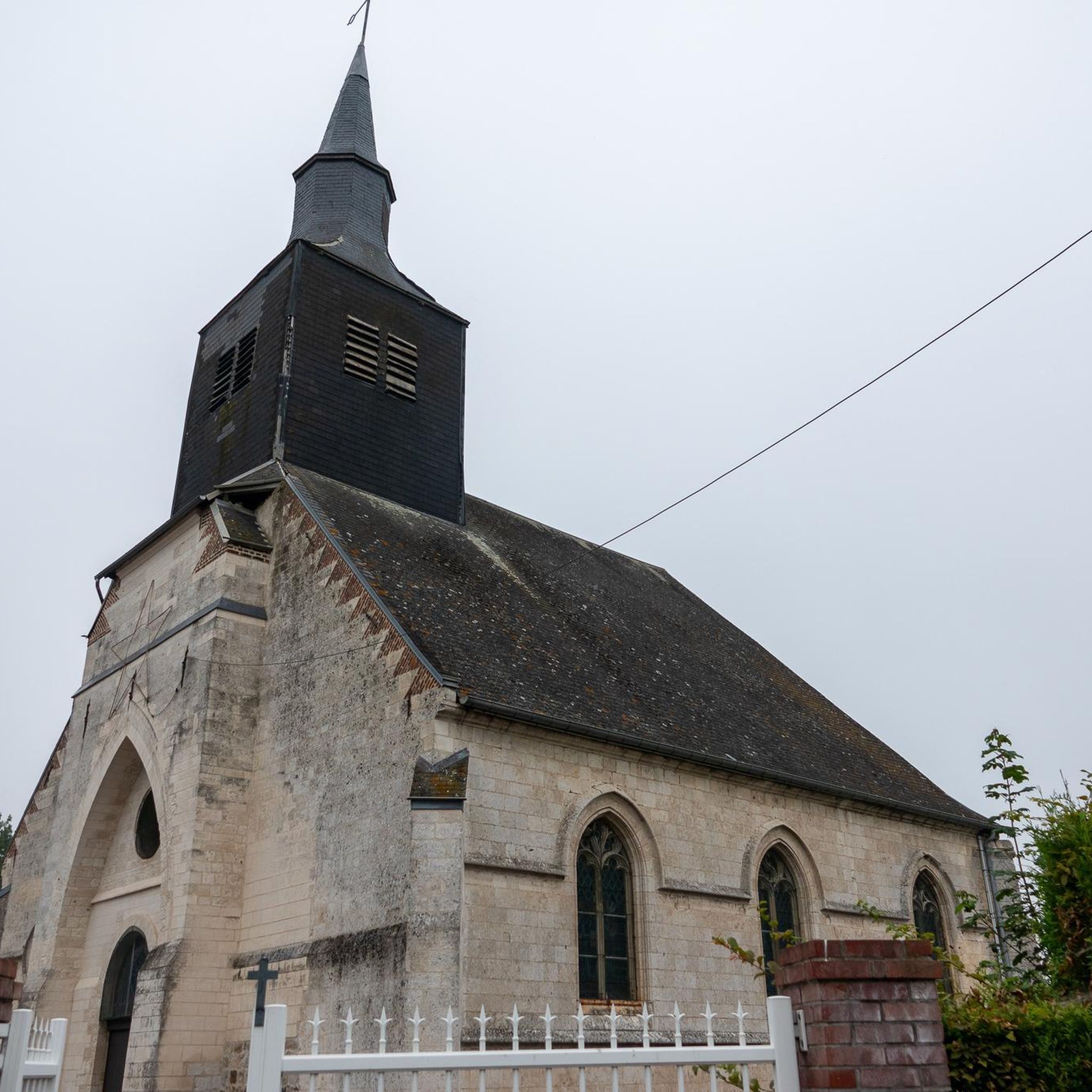
The current church was built in 1803 on the site of the old church. It was restored in 1842. The bell, cast in Douai in 1862, bears the name of its godmother: Aimée Charlotte Henriette de Richoufftz. Its baptismal name, like many bells in our villages, was given after a blessing. It was installed in the steeple, built of cut stone, in 1874, thanks to the generosity of the Richoufftz family. The sound of the bell punctuated rural life and informed the inhabitants of certain events, announcing the dangers, joys, or sorrows of daily life. The church's stained-glass windows feature the Richoufftz family crest: three gold stag heads on a blue background. Manin Castle, built in 1745, is located behind the church.
0
0

To think that soldiers took refuge behind the church and left a trace of themselves for our freedom 🕊️ by leaving us these graffiti. It is my duty of memory to create a must-see on this place full of history to honor them and to show them all my gratitude I went to the grave of one of them killed in Bouchoir on August 9, 1918 (Somme) a few months before the armistice. William David Boag 21 years old 🇨🇦 Never forget 💮. Come and contemplate this place. Thank you Franck.
1
0

The Château de Lignereuil is a castle in Lignereuil. The castle was destroyed by fire in the past and was renovated in the second half of the 20th century. It was once owned by the same lord who owned the castle of Givenchy-le-Noble, and there is a departmental road connecting the two castles. This road is 1800 meters long and is flanked by a double row of centuries-old lime trees that are included in the inventory of historical monuments.
4
0
This church was built in the 16th century, restored in the 19th century and has an impressive bell tower portal. Inside you will see a barrel vault on spandrels, and paintings, such as a holy family (16th C)
4
0
The Château de Lignereuil is a castle in Lignereuil, a commune in the Pas-de-Calais department in northern France1. The castle was destroyed by fire in the past and was renovated in the second half of the 20th century2. It was once owned by the same lord who also owned Givenchy-le-Noble château, and there is a departmental road connecting the two châteaux2. This road is 1800 meters long and is flanked by a double row of centuries-old linden trees listed in the Inventory of Historical Monuments.
1
0

The history of this castle as well as practical information are on the site https://www.arraspaysdartois.com/visites-heritage/le-chateau-de-barly/
1
0

Apart from the old keep that can be seen from the western part of the village, the castle of Lucheux, which has become an IME, has been destroyed several times, has kept among others its doors including the one known as "the village" which is visible from the paved road that goes up of the belfry.
0
0
Frequently Asked Questions
How many mountain bike trails are available around Berlencourt-Le-Cauroy?
There are over 50 mountain bike trails available in the Berlencourt-Le-Cauroy area, offering a wide range of options for different skill levels.
What is the overall difficulty level of mountain biking in Berlencourt-Le-Cauroy?
The trails around Berlencourt-Le-Cauroy are predominantly moderate, with 37 routes falling into this category. There are also 14 easy trails suitable for beginners and one more challenging route for experienced riders.
What kind of terrain can I expect on the mountain bike trails?
You can expect a varied terrain characterized by plateaus, rolling valleys, and bocage. The region features wooded dales offering clear views, vast cereal plains, and gentle green valleys. Many routes utilize unpaved paths, providing a true rural mountain biking experience.
Are there easy mountain bike trails suitable for beginners or families?
Yes, there are 14 easy mountain bike trails in the area. A good option for a less strenuous ride is the Château de Lignereuil loop from Denier, which is 12.7 km long and has minimal elevation gain.
What do other mountain bikers say about the trails in Berlencourt-Le-Cauroy?
The mountain bike routes in Berlencourt-Le-Cauroy are highly rated by the komoot community, with an average score of 4.2 stars from over 40 reviews. Nearly 300 mountain bikers have explored the varied terrain here, often praising the scenic countryside and diverse landscapes.
Are there any long-distance mountain bike routes for endurance riders?
Yes, several routes offer longer distances. For example, the Château de Lignereuil – Château de Barly loop from Beaufort-Blavincourt covers 56.7 km, and the Woods – Château de Lignereuil loop from Beaufort-Blavincourt is 56.3 km, both offering extensive rides through the region's varied landscapes.
What landmarks or attractions can I see along the mountain bike trails?
The region offers several historical and natural points of interest. You might encounter the 16th-century Saint-Sulpice Church (Berlencourt) or the 1680 Château du Cauroy. The broader area also features highlights like the Lucheux Belfry and the Château de Givenchy, which can be incorporated into longer rides.
Are dogs allowed on the mountain bike trails?
While many trails in rural areas are dog-friendly, it's always best to check local signage and regulations, especially when passing through private land or nature reserves. Always keep your dog under control and clean up after them.
What is the best season for mountain biking in Berlencourt-Le-Cauroy?
The green countryside and unpaved paths are generally best enjoyed from spring through autumn. During these seasons, the weather is typically mild, and the trails are less likely to be muddy or affected by winter conditions. Always check local weather forecasts before heading out.
Are there circular mountain bike routes available?
Yes, most of the mountain bike routes listed on komoot for Berlencourt-Le-Cauroy are designed as circular loops, allowing you to start and finish at the same point. An example is the Mountainbike loop from Estrée-Wamin, which offers a diverse landscape of fields and woodlands.
Where can I find parking for the mountain bike trails?
Parking availability varies by trailhead. In general, you can often find parking in the villages near the start of the routes, such as Beaufort-Blavincourt or Estrée-Wamin. Look for designated parking areas or consult local maps for specific recommendations.
Can I reach the mountain bike trails by public transport?
Berlencourt-Le-Cauroy is a rural commune, and direct public transport links to specific trailheads might be limited. It's advisable to check regional bus schedules or consider driving to a starting point, especially if you're bringing a mountain bike.
Most popular routes around Berlencourt-Le-Cauroy
Most popular attractions around Berlencourt-Le-Cauroy

Get inspired with the komoot mobile app


Explore more
Browse the best MTB trails in other regions.
