The best road cycling routes around Reithouse
4.6
(68)
1,211
riders
88
rides
Road cycling routes around Reithouse are situated within the diverse landscapes of the Jura Mountains, characterized by rolling hills, limestone cliffs, and dense forests. The region features numerous lakes and vineyards, offering varied topography for cyclists. This area provides a network of well-maintained roads that cater to different skill levels.
Best road cycling routes around Reithouse
- The most popular road cycling route is Lons-le-Saunier loop from Alièze, an 18.6 miles (29.9 km) trail that takes 1 hour 31 minutes…
Last updated: July 6, 2026
4.7
(6)
20
riders
29.9km
01:31
490m
490m
Moderate road ride. Good fitness required. Mostly well-paved surfaces and easy to ride.
9
riders
92.9km
04:23
1,190m
1,190m
Hard road ride. Very good fitness required. Mostly well-paved surfaces and easy to ride.

Sign up for free
19
riders
48.2km
02:11
430m
430m
Moderate road ride. Good fitness required. Mostly well-paved surfaces and easy to ride.
9
riders
Moderate road ride. Good fitness required. Mostly well-paved surfaces and easy to ride.
4
riders
57.9km
02:37
580m
580m
Moderate road ride. Good fitness required. Mostly well-paved surfaces and easy to ride.
Get access to more routes and recommendations from other explorers.
Sign up for free
Already have an account?
Our route recommendations are based on thousands of hikes, rides, and runs completed by other people on komoot.
Start today with a free account
Your next adventure awaits.
Login or Signup



Tips from the Community

A bit of welcome freshness
0
0

The bridge separates two departments, the Jura and the Ain. "Iron bridge. For several centuries, the Ain was crossed at Thoirette using a ferry, called Christouphe's ferry, named after the commune where the passenger resided. From 1808 to 1811, the riparian communes contributed to building a bridge in place of this ferry. The project had been drawn up by Mr. Cordier, from Orgelet, an engineer then in charge of directing the works for the Simplon road. Various obstacles opposed the execution of this work. It was not until 1829 that an iron bridge was built, which collapsed in 1843. The Ain department has just replaced it with an iron bridge currently open to traffic". Statistique de la France - 1855 - Ministère de l'Agriculture by Imprimerie Impériale in Paris - p53.
0
0


Correction to my tip: Asphalt with mixed traffic, for residents, but I couldn't see where the residents wanted to go. It's a shame, some sections of the asphalt are no longer in such good condition.
0
0
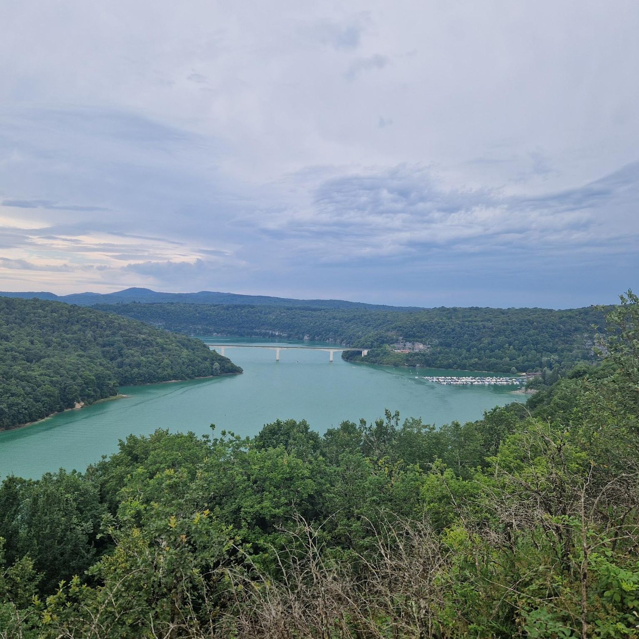
Parking lot on the road with a beautiful view of the Lac de Vouglans, crossed by the Ain.
0
0

This view of Lake Vouglans is a breathtaking panorama of deep blue waters framed by rolling hills and lush green forests. As you approach, the lake stretches for an impressive 35 kilometres. Vouglans is the third largest artificial lake in France, created by the construction of the Vouglans Dam.
1
0

Frequently Asked Questions
What kind of terrain can I expect on road cycling routes around Reithouse?
The road cycling routes around Reithouse are characterized by the diverse landscapes of the Jura Mountains. You'll encounter rolling hills, dense forests, and picturesque vineyards. The region features varied topography, including some challenging climbs and descents, ensuring a dynamic cycling experience.
Are there road cycling routes suitable for beginners or families in Reithouse?
Yes, Reithouse offers routes for various skill levels. There are 11 easy road cycling routes available, perfect for beginners or families looking for a more relaxed ride. An example of an easy route is the Orgelet - Vernantois – Château de Verges loop from Dompierre-sur-Mont, which covers 38.7 km with moderate elevation changes.
What are some of the more challenging road cycling routes in the Reithouse area?
For experienced cyclists seeking a challenge, Reithouse offers 18 difficult routes. These often feature significant elevation gains and longer distances. A notable challenging route is the Vouglans Dam – View of Lac de Vouglans loop from Dompierre-sur-Mont, a 92.7 km path with over 1,100 meters of elevation gain, offering stunning views of Lac de Vouglans.
What scenic attractions or viewpoints can I discover along the road cycling routes?
Many routes offer breathtaking scenery. You can cycle past numerous lakes, such as Lac de Vouglans, and through charming vineyards. Specific viewpoints include the Guillotine Viewpoint and the View of Lac de Vouglans. You might also encounter interesting structures like the Metal Bridge and Tunnel of the Voie PLM or the Révigny Metal Viaduct.
Are there any long-distance road cycling routes or tours in the region?
While many local routes are day trips, the Jura Mountains are home to longer cycling adventures. For seasoned cyclists, the 250km Tour du Jura à Vélo Sport is a significant route traversing diverse landscapes and featuring challenging climbs. You can find more information about this route on France Vélo Tourisme.
What is the best time of year for road cycling around Reithouse?
The best time for road cycling in Reithouse is typically from spring to autumn (April to October). During these months, the weather is generally mild and pleasant, making for ideal cycling conditions. Summer offers warmer temperatures, while spring and autumn provide beautiful scenery with fewer crowds.
What do other road cyclists enjoy most about the routes in Reithouse?
The road cycling routes around Reithouse are highly rated by the komoot community, with an average score of 4.7 stars from over 50 reviews. Cyclists often praise the varied terrain, from rolling hills to scenic lakeside paths, and the well-maintained roads that wind through the beautiful Jura landscapes.
Are the road cycling routes around Reithouse typically circular?
Yes, many of the road cycling routes around Reithouse are designed as circular loops, allowing you to start and end your ride at the same point. This is convenient for those traveling by car. For example, the Lons-le-Saunier loop from Alièze is a popular circular route.
Are there any routes that pass through vineyards or wine regions?
Yes, the Jura region is known for its vineyards. Many road cycling routes will take you through picturesque wine regions, offering a chance to enjoy the unique landscape and potentially stop at local producers. The region's diverse scenery includes routes specifically designed to showcase these areas.
How many road cycling routes are available in total around Reithouse?
There are nearly 100 road cycling routes available around Reithouse, offering a wide variety of options for different distances and difficulty levels. This extensive network ensures there's a suitable ride for every road cyclist.
Can I find routes that include historical or cultural points of interest?
Absolutely. The region has a rich history. For instance, the 20 gods 🎞📽 – Gigny Abbey loop from Saint-Laurent-la-Roche is a route that leads through varied terrain and passes by Gigny Abbey, offering a blend of natural beauty and cultural exploration.
Most popular attractions around Reithouse

Get inspired with the komoot mobile app


Explore more
Browse the best Road cycling routes in other regions.
