The best MTB trails around Aguilcourt
4.5
(48)
497
riders
38
rides
Mountain biking around Aguilcourt offers a network of trails through a landscape characterized by historical fortifications, rolling agricultural land, and pockets of woodland. The region features varied terrain, including gentle slopes suitable for leisure rides and more challenging ascents around the former fortresses. These routes often traverse open fields and vineyards, providing diverse riding experiences. The area's topography is generally undulating, with no major peaks, making it accessible for different skill levels.
Best mountain bike trails around Aguilcourt
- The most…
Last updated: June 25, 2026
4.8
(4)
87
riders
53.4km
04:47
830m
830m
Hard mountain bike ride. Good fitness required. Advanced riding skills necessary. Some portions of the route may require you to push your bike.
3.7
(3)
42
riders
19.6km
01:39
230m
230m
Easy mountain bike ride. Great for any fitness level. Suitable for all skill levels.

Sign up for free
5.0
(7)
57
riders
33.7km
03:02
570m
570m
Hard mountain bike ride. Good fitness required. Advanced riding skills necessary. Some portions of the route may require you to push your bike.
16
riders
9.30km
00:54
170m
170m
Easy mountain bike ride. Great for any fitness level. Suitable for all skill levels.
9
riders
25.4km
02:05
300m
300m
Hard mountain bike ride. Good fitness required. Advanced riding skills necessary. Some portions of the route may require you to push your bike.
Get access to more routes and recommendations from other explorers.
Sign up for free
Already have an account?
Our route recommendations are based on thousands of hikes, rides, and runs completed by other people on komoot.
Start today with a free account
Your next adventure awaits.
Login or Signup
Tips from the Community

Be careful with the leaves. It's a bit slippery.
0
0

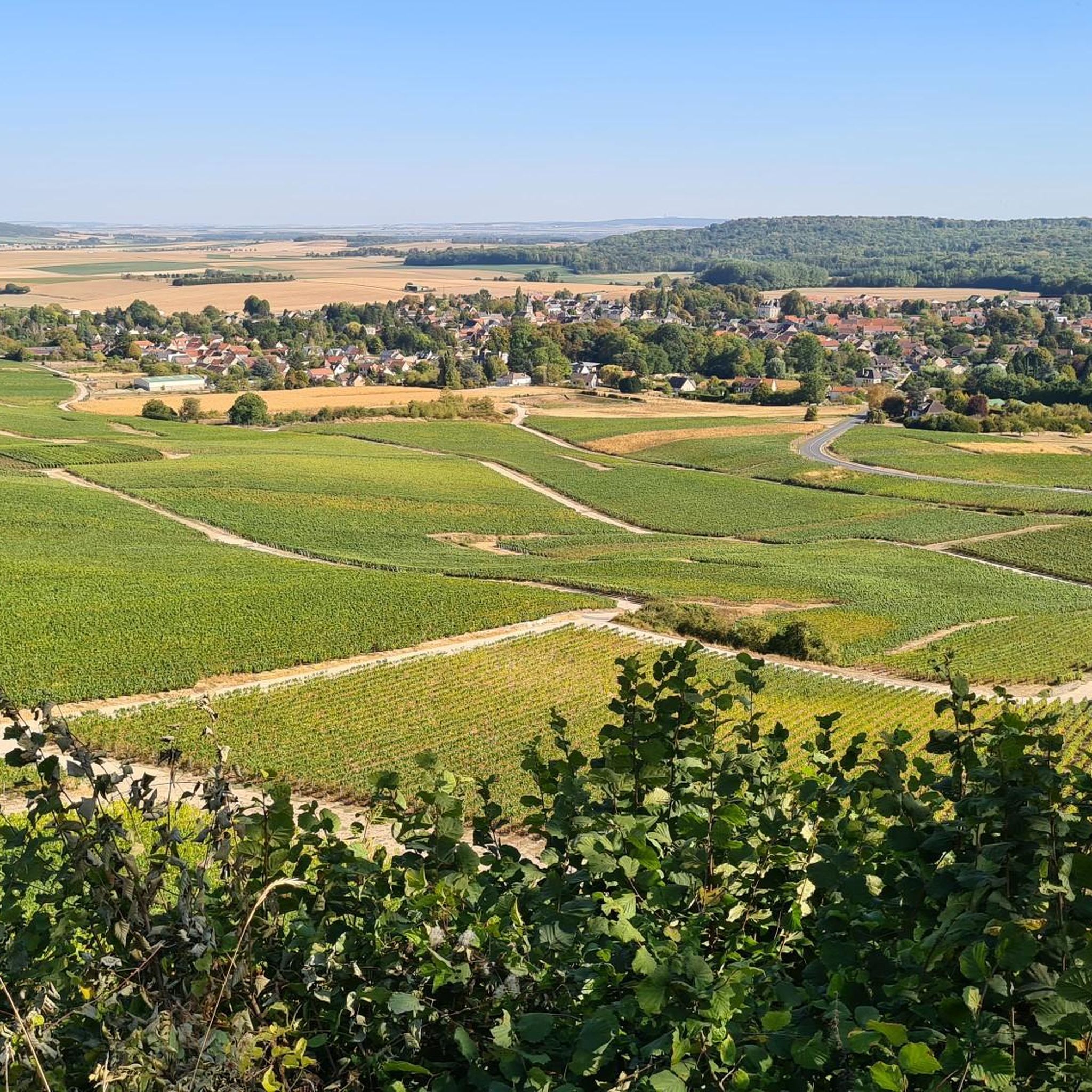
To the northwest of Reims, the Chenay vineyard is made up of a vast plateau on which stretch beautiful champagne vines. In autumn, the spectacle is even more magnificent.
2
0

Fort Brimont is one of several forts built around Reims after 1870 as part of the fortified belt of the Séré de Rivières system built to make the city a rear stronghold. Access to the fort is closed.
0
0


impressive ruins of a huge fortress, entry is prohibited without guidance, but you can drive up to the entrance gate, for info visit https://www.facebook.com/FortSaintThierry - a non-profit organization that works for the restoration..
4
0

there are several trails in this wooded section. very beautiful and fun
0
0

Starts along a field Roots, rocks. Attention possible presence of pedestrians.
0
0
Frequently Asked Questions
How many mountain bike trails are available around Aguilcourt?
There are over 35 mountain bike trails around Aguilcourt, offering a variety of experiences through historical fortifications, agricultural lands, and woodlands. The komoot community has explored these routes over 450 times.
Are there easy mountain bike trails suitable for beginners in Aguilcourt?
Yes, Aguilcourt offers several easy mountain bike trails. An excellent option for a relaxed ride is the Batterie de Loivre – Fort de Brimont loop from Loivre, which is 11.4 miles (18.4 km) long and takes about 1 hour 30 minutes to complete. Another easy route is the Fort de Brimont loop from Brimont, a shorter 5.8 miles (9.3 km) ride.
What kind of terrain can I expect on mountain bike trails in Aguilcourt?
The terrain around Aguilcourt is generally undulating, characterized by rolling agricultural land, scattered woodlands, and historical fortifications. You'll find a mix of gentle slopes and more challenging ascents, particularly around the former fortresses, but no major peaks.
Are there any challenging or advanced mountain bike routes in Aguilcourt?
Yes, for experienced riders, Aguilcourt offers several difficult routes. The Fort de Chenay – Vinyard of the Chenay loop from Berry-au-Bac is a demanding 33.2 miles (53.5 km) trail with significant elevation gain, typically taking around 4 hours 43 minutes. Another challenging option is the Fort de Chenay – Vinyard of the Chenay loop from Loivre, covering 20.1 miles (32.4 km) in about 2 hours 55 minutes.
Are there circular mountain bike routes available in Aguilcourt?
Many of the mountain bike trails in Aguilcourt are designed as circular routes, allowing you to start and finish at the same point. Examples include the Batterie de Loivre – Fort de Brimont loop from Loivre and the Fort de Brimont loop from Brimont.
What are the typical lengths and durations of mountain bike trails in Aguilcourt?
Trail lengths vary significantly, from shorter rides like the 5.8 miles (9.3 km) Fort de Brimont loop from Brimont taking about 1 hour, to longer, more challenging routes such as the 33.2 miles (53.5 km) Fort de Chenay – Vinyard of the Chenay loop from Berry-au-Bac, which can take nearly 5 hours.
Are there any interesting landmarks or attractions to see along the mountain bike trails?
Yes, the region is rich in history. Along your rides, you might encounter sites like the Cormicy National Necropolis or the St. Pierre Church in Guignicourt. The trails often traverse areas with historical fortifications and vineyards, offering scenic and cultural points of interest.
What do other mountain bikers enjoy most about the trails in Aguilcourt?
The mountain bike trails in Aguilcourt are highly rated by the komoot community, with an average score of 4.6 stars from over 40 reviews. Riders often praise the diverse riding experiences, which combine historical sites with open fields and vineyards, and the options available for different skill levels.
Are there mountain bike trails in Aguilcourt accessible by public transport?
While specific public transport connections to trailheads are not detailed in the route descriptions, many routes start from towns like Loivre or Berry-au-Bac, which may have regional bus services. It's advisable to check local public transport schedules for connections to these starting points.
Are there mountain bike trails in Aguilcourt with convenient parking?
Many of the komoot routes around Aguilcourt start from villages or accessible points where parking is typically available. For example, routes like the Batterie de Loivre – Fort de Brimont loop begin in Loivre, and the Fort de Brimont loop starts in Brimont, both of which are likely to have parking options for visitors.
Can I find less crowded mountain bike trails in Aguilcourt?
While some popular routes might see more traffic, Aguilcourt offers a network of trails through agricultural lands and woodlands, providing opportunities for quieter rides. Exploring some of the moderate or difficult trails, such as the One of TT CC – Tttttttt 5gttty loop from Berméricourt, might lead you to less frequented paths, especially during off-peak times.
Most popular routes around Aguilcourt
Most popular attractions around Aguilcourt

Get inspired with the komoot mobile app


Explore more
Browse the best MTB trails in other regions.
